Friday, July 29, 2016

Mt. Kilimanjaro Climb - July 2016

In mid-July 2016 we took a trip to Tanzania with the goal of climbing Kilimanjaro and then following it up with a more relaxing safari in the Serengeti.  The “we” were Nancy, her two daughters, Erica and Arden and myself.  We signed up for the trip with a tour company (Tusker) who were based in the USA, in Truckee, California of all places, just a few miles up the road from Sacramento.  We didn't choose them because they were close to home, we chose them because they could provide a trip that fit all our timing needs. We were extremely happy with the company and would certainly recommend them to anyone heading that direction.

I had always wanted to climb Kilimanjaro ever since an aborted attempt to climb it by myself in 1973. I have no doubt that my earlier attempt would have been destined for failure even if the police had not taken me off the mountain for failing to get the required permits and engage guides and porters. I was seriously ill equipped for such a climb at that time but then I had youth on my side.  This time I no longer had youth working for me but I was a better prepared equipment-wise and at least fully permitted.


I flew out from the USA early to spend a week in the UK before traveling down to Tanzania. Then after I had recovered from jet lag, I flew from London to Tanzania via Istanbul. I arrived in Istanbul a week after the terrorist bombing at the airport.  All appeared to be business as usual when I landed in Istanbul and there were no problems with the transfer to my Tanzanian flight.  I flew into Kilimanjaro International Airport which is the airport positioned between Arusha and Moshi that serves the safari and Kilimanjaro climbing industry in Tanzania (that industry is a significant earner for the Tanzanian economy).  I landed in the middle of the night and patiently joined the queue to get my $100 visa to enter the country.  $100 is, of course, a significant cost but I checked the tourist visa requirements for a Tanzanian visiting the US and for them there is a $160 application fee and an interview at the consulate is needed prior to issuance. That has to hurt way more than my $100 visa issued on entry at the airport.

With my visa in order and despite the early hour I was met outside the airport by the tour company representative who whisked me off to my hotel in Moshi (the quite adequate but not too luxurious Parkview Hotel).  


Moshi is the closest large town near to the base of the mountain and it appears to be the location for all the Kilimanjaro climbing tour companies, of which there are many.  It is not a particularly pretty town, being a bit shabby and dusty, though it is quite bustling with activity.  The center of town can be walked in an hour or so. I walked around the old railway station but alas the train doesn't run there anymore. It was encouraging to see churches, mosques, and hindu temples all within close proximity of each other - Tanzania so far appears to be one of the more stable countries in Africa.
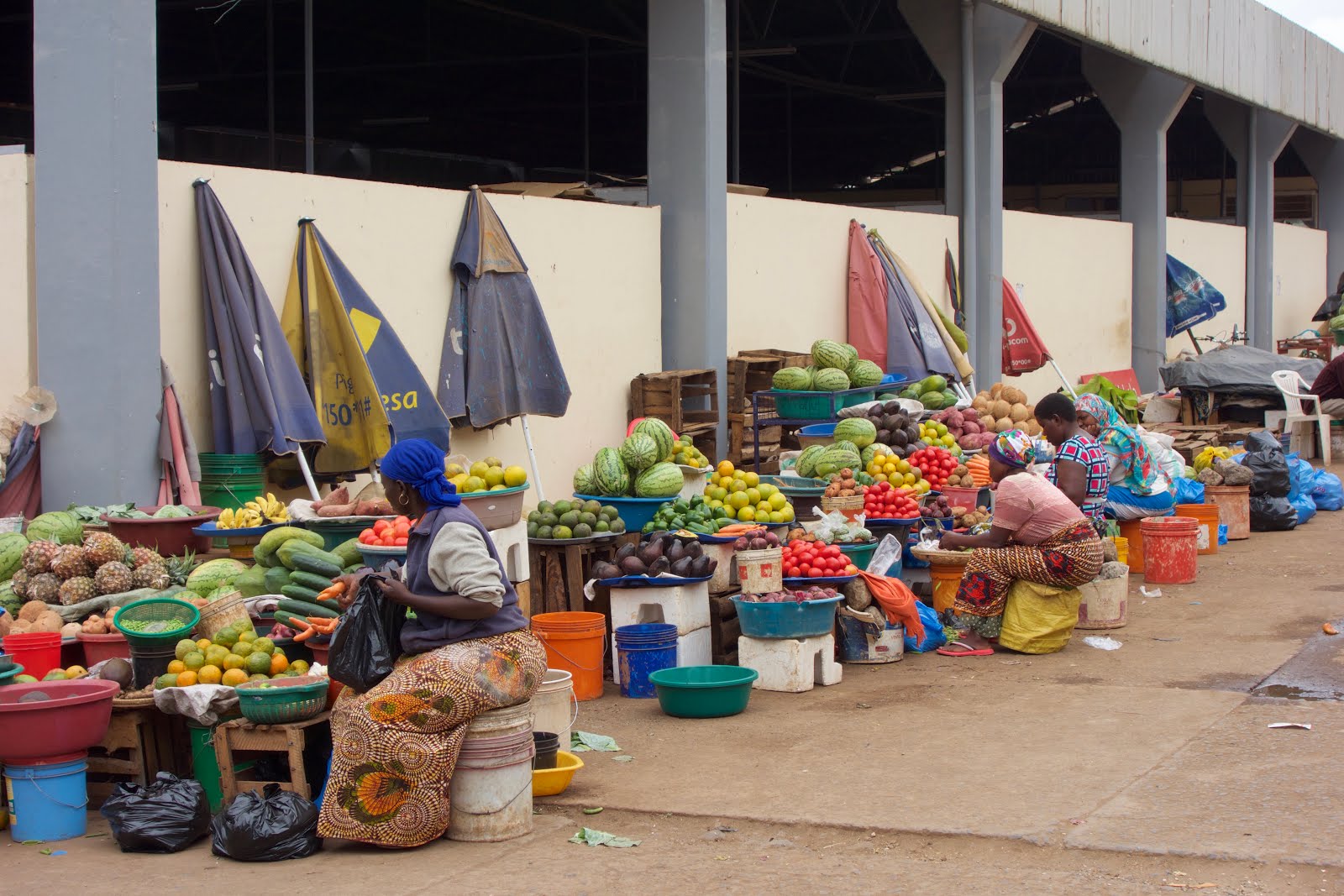
Moshi Market
Nancy, Erica and Arden came in via Qatar the next afternoon (Sunday).  We had a quiet evening as they wrestled with their jet lag after a very long flight from the west coast of the US and we spent most of the time trying to get our equipment organized.  Climbing a mountain from tropical rain forest up to snow capped peak requires a lot of different clothing and equipment, not to mention all the additional gear for a follow on safari.  We all had a lot of stuff to sort out.


The next day Monday, our guides for the climb (Elyakim and Stanford) came over and gave us a briefing on what to expect on the mountain.  They checked out our gear in great detail to make sure we had everything we would need.  Any items we didn’t have could then be hired or purchased in Moshi. In the afternoon, we wandered around town some more and in the evening we had a meal at a "reasonable" Italian restaurant (you don't come to Tanzania for the food) before retiring for the night.  If the truth be known, we were all a bit anxious about our ability to complete the climb - 19,000ft is not an insignificant altitude and from Moshi the mountain looked absolutely immense.
Machame Gate - start of the trail
Tuesday morning we set off early for the trail head.  We were climbing the Machame Route - a 7 day trip that allows a reasonable amount of time to acclimatize on the ascent.   We would be 6 days climbing up, and then 1.5 days coming down. The downhill route is a much shorter and more direct route.  When we arrived at the trailhead it was drizzling with rain so we geared up with our wet weather clothing and anxiously awaited our depart while our guides did all the paperwork at the Park office. There were several other groups starting at the same time and all of which looked better equipped than we did.  


I was surprised to find that for our group of 4 people we had another 24 individuals assisting us - 2 guides, a cook, a waiter, a camp manager, a safety guy (who carried a stretcher and inflatable pressure bag), and 18 porters.  It seems excessive but apparently it is quite normal.  All we carried ourselves was a day pack with extra clothing, water, food for the day, and whatever we needed until we got to camp.  The porters carried everything else along with food, water, tents, etc. Each porter could carry a load not exceeding 25 kilos (55lbs) and each of their loads was weighed as we left the trailhead.
On the trail in the Rainforest Zone - Elyakim, Nancy, Arden, Erica
The first day’s hiking was not the best - we were in the rain forest and it was misty and dripping with rain so we were warm and damp as we climbed.  Being in the forest, there were no real views and the trail was uphill the entire day.  There was never any respite for the relentless uphill slog.  It was however a reasonable grade and the trail itself though quite slick in parts was very well maintained and surprisingly clean considering all the traffic it gets.

We stopped for a box lunch and had our first introduction to the quantity of food we were going to be presented with on the climb. One of the philosophies of our tour company was that a well fed and well hydrated climber has a better chance of making it to the top so we always had plenty of food available to us. We probably only ate half of the packed lunch.

There was some question about the distance we had to cover the first day - one map said 18 km and another said 11 km. Thankfully, I think it was more like 11 km but we were  walking for about 6 hours which was quite enough for the first day.  As we got higher we got out of the damp forest and the rain stopped making it a lot more pleasant.  Arriving in the first camp, Machame Camp, we found it to be quite crowded and busy.   There were a lot of groups each with a lot of tents and we were all quite tightly spaced.  Our group of tents were very good - a couple of 2 man tents for ourselves, another 2 man for our guides, a cook tent, a dining tent, a toilet tent (essential) and then a few larger tents for the porters - all expedition grade equipment.  
Machame Camp
We were now above the cloud level and as the clouds cleared from around the mountain in the early evening we could see the summit ahead of us.  It looked very, very high and a long, long way away.  We had started from the trailhead at 5,900 ft and the Machame Camp was at 9,300 ft - 3,400 ft of gain.


DInner was served and we had the first of our wonderful meals on the trail.  We always had a 3 course dinner with a very excellent soup course, a meat based main course and some sort of desert.  Our cook who went by the name of Tosha did an excellent job in the cook tent with just a couple of propane burners.
Paella - one of the fine food offerings every night
After dinner our guides gave us a briefing on what to expect the next day and then proceeded to check our health.  Each night and morning they measured our blood oxygen content and listened to our lungs and asked a bunch of questions about how we felt.  That gave us a bit of confidence in that we were still healthy enough to proceed.  I should also say that by this time we were all taking Diamox to aid in the symptoms of altitude sickness.  We were also taking Malarone for Malaria as Moshi is a malarial area.  The Diamox makes you pee a lot, not an easy thing at night in a tent, and the Malarone makes you have weird dreams.

The next morning we were the last out of camp and the previously crowded camp was almost deserted by the time we left, just a few porters packing up the remains of their equipment.  The porters then rushed on ahead to pitch camp at the next level while we continued upwards at a more leisurely pace on what was a fairly pleasant trail.  They called this the heather zone - low scrub and bushes and a bit more open than the lower rain forest zone.  It was of course up the whole way.  
Shira Cave Camp
We again were pretty tired when we reached our camp for the night - Shira Cave Camp.  The day's hike was about 5 km and the elevation gain was 3,000 ft up to the 12,300 ft. level.  The air was getting thinner all the time.  Nancy had a few issues early on in the day with nausea that were perhaps related to one of the medications, but other than that we were all feeling pretty good.  
The Lava Tower
Day 3 on the trail took us up to the Lava Tower, a plug of lava that is quite a landmark.  Lava Tower Camp is at 15,100 ft and it was the highest any of us had ever been.  Surprisingly we were all feeling fine - no headaches, no nausea, just a little out of breath.  We reached the Lava Tower at lunchtime and our cook had set up shop to provide us with a wonderful lunch of soup and pork fajitas.  The food was really very, very good, but, instead of taking a nap after lunch, we had to press on to the next camp for the night - not so easy on a full stomach.  Lava Tower was the highest point for the day and the afternoon’s hike to Barranco Camp was mostly downhill to 12,800 ft.   Barranco was a very nice campsite with plenty of space and magnificent views of the mountain.  The mountain still looked a long way away and it was very, very high.
On the Trail
Each night at camp we had to sign into the register at the warden’s office.  You had to enter your name, country of origin, guide name, trekking company, etc and your age.   Each night I checked to see who was the oldest on the mountain - it was me, and Nancy was the oldest female.  I don’t know if that’s something to be proud of or not. Shouldn't we know better by our age.
View from Barranco Camp
Next day (Day 4) the way out of Barranco Camp was up the Barranco Wall.  This was perhaps the most technical bit of the entire climb.  It was a scramble up the steep side of a cliff.  The hand and foot holds were large and there were plenty of them but you did have to pay attention.  Of course the porters all made it up the Wall with no problems while carrying heavy loads on their heads or shoulders - no fancy packs for them just big duffel bags or baskets - and no fancy boots or clothing either - most were clad in cast offs from earlier foreign climbers.
Scrambling up the Barranco Wall
This day was relatively short, only 6 km and other than the Barranco Wall not too much up hill.  There were lots of the weird and wonderful trees and plants along the way - the Senecio Kilimanjari, the giant lobelias, the pretty white straw flowers whose name I do not know.  
Senecio Kilimanjari
We all welcomed the early sighting of our next camp, Karanga Camp, in the near distance only to find that we had to scramble down a deep and steep valley and up the other side before we reached our tents.  A perfect place for a zip line across the valley. Karanga Camp was at 13,100 ft. and was another more spacious camp but still with intimidating views of the summit looming in the distance.  We were all feeling fairly breathless by now but we had no other ill-effects of the altitude like headaches or nausea.


The view from Karanga Camp - its still a long way up
Our guides made a big deal about being well hydrated and were always chiding us to drink.  They wanted us to consume 3 to 4 liters of water each day.  That is a gallon of water and that is a lot to consume.  I would try and slug down a liter at breakfast and the a couple on the trail and maybe half a liter at night.  Rarely did I succeed in the full amount. That and the diuretic effects of the Diamox did not bode well for an uninterrupted night's sleep in the tent and the simple act of getting out of the sleeping bag and tent at that altitude left me breathless.
Aristide, always followed us with the stretcher and pressure bag
The next day (Day 5) was a short day only 3.5 km up to Barafu Camp at 15,300 ft.  This would be our highest camp and the next day we would attempt the summit.  We had been having doubts as to whether we could make the summit as it always looked so distant and high but as we were still altitude symptom free we were feeling somewhat optimistic when we arrived in Barafu.  That is until Arden started feeling ill - headaches, nausea, feeling like she might pass out.  She was not having fun and she did not look good.  The guides brought her into the warmth of the cook tent and gave her oxygen and we tried to console her but she was obviously troubled.  That night Nancy slept in Arden and Erica’s tent leaving me all alone and frankly I did not think Arden would continue up the next day.
From Barafu Camp it was still a long way away


The reason that Day 5 was a short hike was that many or even most people ascend to the summit in the night to arrive on top as the sun rises.  We had decided earlier not to do that and ascend in the daytime, and with Arden not feeling well it only reinforced that decision.  I did get up in the middle of the night and saw a long stream of lights making their way up the hill.  That was a wonderful sight from down below, but I don’t think that the sunrise on the top would be much different to sunrise at 15,000 ft and the cold and dark climb could not be all that pleasant.


On day 6, the summit day we were due to get going on the trail by 6:00 am and to my surprise everyone was feeling, if not perfect, at least better than the night before so the summit was on for all of us.  It was still dark and cold as we got ready to leave and the sun came up just as we left camp.  It was a steady fairly steep uphill climb and we were walking slowly, very slowly, taking breaks every hour.  With the altitude and the steep climb it was so easy to get completely breathless and so slow and steady was the only way to do it.  The swahili for slowly was “pole pole” and it became the mantra as we ascended.   Around 9 or 10 we saw the first people descending the mountain. Presumably they had made it to the top for sunrise, though there was at least one poor man who was moving very slowly down and he looked terrible - perhaps he abandoned the quest before the summit.  I saw a statistic after I got home that said only 64% of 7 day climbers reached the top.  That number seems a little low but obviously there are those that don’t make it.
On the way to the Summit from Barafu Camp
The steep part of the climb to the summit finishes at the rim of the crater, a point called Stella Point which is at 18,900 ft. I guess I hadn’t been paying attention to how far we had climbed so it came as a complete surprise when we popped out at the crater's edge.  From there it was a gentle rise for about a kilometer to the summit at 19,300 ft.  Arden was again not feeling great so a little oxygen was administered to get her to the summit.
On the Summit - 19300ft
When we got to the top there was only one other group of three climbers there so there was no waiting to get summit photos like there must be for the sunrise summit.  I heard there might be 30 or 40 people there queuing up for photos in the early morning - not something I would want to do in the extreme cold. We snapped the required photos of us looking oh-so-happy and then really didn’t spend too much time at the summit.  It was 2:00 pm and we had a long way down ahead of us.  
The Snows of Kilmanjaro
There is certainly some snow and a few small glaciers at the summit though the amount of snow and ice is decreasing as the years go by. We didn’t have to walk on snow at all - the trail was completely clear.  The crater at the top is quite spectacular and there is even a camp in the bottom of the crater for the more adventurous climbers.   Not many people seem to stay there.  


On the way down my boots started to give me a bit of trouble and although the going was easy and quick it was a little painful for the feet.  The ladies were assisted on the way down by the porters and apparently this was quite a ride - they were each grabbed on the arm by a porter and then they both took off downhill at almost a running speed. I couldn't understand how quick they were moving, usually with my long legs I can get down quite fast but I could barely keep up.


When we arrived back in Barafu Camp, there was a celebratory welcome from all the guides and porters - a kind of song and dance routine.  All well and good but at that moment all I wanted to do was collapse in the tent.

After a small meal we were back on the road again by about 5:30 pm.  Onward downhill by a more direct route to the next camp - Millenium Camp at 12,500 ft.  That is quite a descent, some 7,000 ft in just a few hours.  On the way down we were passed by a stretcher party hurtling down the trail with an injured porter (not one of ours).  The stretchers with handles at either end and a wheel in the middle don’t look like they give you a smooth ride down but they certainly move fast.  We learned later that the injured ported had fallen while transporting water up the hill to his camp.  


It was dark when we came into Millenium Camp - our last camp on the mountain.  We were exhausted and probably would have collapsed into our tents but as usual they had prepared another meal for us.  When we did retire we were completely exhausted but quite pleased with our efforts.
Our Porters on the way down from Millenium Camp
The next morning (Day 7) we had the usual fine breakfast and then left for the trailhead and our transportation back to Moshi.  We passed into the Tropical Rainforest zone and things got damp again but it wasn’t cold enough to make me put on waterproofs.  On the way down we went through Mweka Camp where we were passed by the young Australian group on their descent.  We had seen these folks several times before on the way up and they were always a quite boisterous and fun group.  On the way down they were all clad in animal suits - zebras, lions, giraffes.  Very weird - how on earth did they have the room to pack those things up the hill and they certainly didn’t look like the most comfortable of hiking gear for the warm climate.


As we got lower down and closer to the trailhead, we did see some Blue Monkeys.  The only non-bird wildlife that we saw on the entire mountain.  As far as birds go, up higher, we were always accompanied in camp by the White Necked Ravens.  These impressive birds are great scavengers of the debris left behind after camp or after lunch on the trail.
Finished
At the gate, our entire porter team were there to welcome us once again.  We signed out at the Ranger Station and wearily climbed into our van for the short ride back to Moshi and the Bristol Cottages Hotel.  What a relief to shower and clean up.  What a great trip.  We were all feeling quite proud of our efforts.
Elyakim
Stanford
We are very grateful to our guides Elyakim and Stanford, our cook Tosha, our waiter Hassan, Aristide, our trusty safety guy who carried the stretcher at all times, our camp manager Charles and all the other anonymous porters that carried our load to the top and back.


On a more sobering note, we learned later that the day after we summited a young South African Rally Driver, Gugu Zulu, died while attempting the summit.  


Wednesday, June 29, 2016

Road Trip to Chicago - June 2016

During Early June I made a road trip to Chicago Illinois.  The purpose of the trip was to deliver Nancy’s car to her daughter who lives in Chicago.  Nancy was in Montana already so I drove from Sacramento to Montana where I picked up Nancy and we drove from there to Chicago.  Of course the trip was a more or less leisurely trip with plenty of opportunity to see various sights and oddities along the way.

I started from Sacramento on Thursday morning and made the well traveled path (for me) up I-80 to Truckee and into Nevada.  I passed through Reno and Winnemucca and stayed the first night in Elko.  I have stayed in Elko many times and I quite like the town. I stayed at the Thunderbird Motel, an old hotel in downtown with a wonderful old neon sign and I dined in perhaps the best place in the downtown area - Luciano’s.

The next morning it was more of I-80 to the down-on-its-heels town of Wells.  I drove around the older part of town which has lots of old motels, bars and casinos that are now closed and deserted.  What a sad but interesting place.   Once a lively town and now passed-by by the freeway.
The Wild West Inn, Jackpot, Nevada
North from Wells I headed for Idaho on Highway 93.  The border town on the Nevada side is the aptly named Jackpot.  It has a much grander and modern casino but not half as interesting as downtown Wells.  

The first large town in Idaho was Twin Falls.  I didn’t see any falls, but I did wander around town a bit before lunching in a mediocre coffee shop. Twin Falls is unusual in that it is not laid out in a N-S grid like most towns, it is on a 45 degree grid. That is a bit confusing especially when there are still North and South named streets.
Snake River outside Twin Falls
From Twin Falls I traveled East towards Pocatello.  On the road there was an overlook where apparently there is evidence of old wagon trail ruts from the Oregon Trail.  I saw the sign in a field of long grass and I wandered around for a while, but I couldn’t make out any ruts.

I skirted around Pocatello and headed north on I-15 to Blackfoot.  Blackfoot has the honor of hosting the Idaho Potato Museum.  A must see if you are passing that way but I wouldn’t make a detour to visit it - not the most interesting museum, though they do have a nice collection of potato mashers (really - an entire display case full of them covering one wall).   Out of state visitors can get a free packet of dehydrated potatoes if they should need one.

The Idaho Potato Museum, Blackfoot
From Blackfoot I diverted off the Interstate to Highway 26 towards Atomic City and Arco in search of the first Nuclear Power Station in the world.  I thought Atomic City might be the location but not quite it is out in the middle of nowhere - EBR-1, the first working power station that generated nuclear power.  They only generated enough power to illuminate 3 light bulbs but it was the first time it had been done and it proved the concept.  The facility is now devoid of nuclear fuel and is open as a museum.  Fascinating to think that they did this back in 1951 out here in the middle of Idaho.   Also on the site is a prototype engine for a nuclear powered aircraft.  The project was canceled before it was ever mounted in an actual aircraft.  There is currently a lot of nuclear research going on at the nearby Idaho National Labs (INL).  On the road to Atomic City I was passed by several large anonymous buses taking employees from INL to Pocatello.  No one lives on the INL site and one wonders what they get up to out there.

The first two light bulbs powered by Nuclear Power
EBR 1 Reactor, Idaho
After the EBR-1 museum I continued into Arco.  This is the first town to receive its electric power from a nuclear power station (EBR-2 I think).  In the middle of the town is the conning tower from a submarine - the serial number of the submarine is 666 (a number that has dark significance to some people) and the boat has been referred to as the Devil’s Boat.  The link between the city and the submarine is the fact that in the nearby Idaho National Labs research was carried out on the power unit for nuclear powered submarines.
The Devil's Boat Conning Tower
From Arco continuing on Highway 26 brings you to the Craters of the Moon National Park.  This is a volcanic area with lava flows, lava tubes, splatter cones and all sorts of other surface volcanic activity.  It would probably be a pretty hot and inhospitable place in the summer but when I visited in the late afternoon at the end of spring it was quite pleasant.  But the crowning glory was not the geology it was the flowers - they were in bloom and the black volcanic soil was covered with small purple flowers.


Craters of the Moon National Park
I drove around the park and then headed out towards Sun Valley for the evening.  Sun Valley was a bit affluent (and high priced) and I ended up staying in the slightly more downmarket Hailey.  In the evening I visited Ernest Hemingway’s grave in Ketchum.  A simple granite gravestone under a tree in the cemetery.  It was adorned by lots of pennies and a bottle of white wine and a bottle of Pabst Blue Ribbon.
Ernest Hemingway's Grave
The next day, Saturday, I drove up through Sun Valley and then through Wood River Valley and the Sawtooth Range.  A wonderful drive through some amazing country.  I breakfasted in Stanley which is a bit of an outdoor center for rafters, canoers, hikers and campers.  The Stanley Museum was worth a look - built to a high standard by the Conservation Corps.  


Continuing on Highway 75 the road down the Salmon River Valley was beautiful.  I stopped at the small museum in Clayton which is full of all sorts of historical artifacts.  There I met a refugee from the LA area who had sold up and moved with her husband to Clayton.  Life for them in Clayton sounded idyllic and a whole lot cheaper than LA.  They were even a mixed race couple and that surprised me given Idaho’s white supremacist reputation.  Continuing on past hot springs, where the water was indeed very hot, I headed north on highway 93, still alongside the Salmon River, into Challis and Salmon, the Bitterroots, into Montana and finally ending the day in Missoula.


Missoula is quite a nice town - a university town on the Clark Fork River with a nice feel to it.  My friend John Griffing who is from Missoula told me that I should hike up the mountain above Montana State University as far as the M.  Many towns in the USA have a large initial for the town marked on the hills above the town (presumably to help identify the town to passing aircraft?  I don’t know.).  Anyway the Missoula M is a nice one and from the top you have a nice view of the town below.  It was a popular early evening hike amongst the locals too.

The M in Missoula
I also visited the Kettlehouse Brewing Company (also on John G’s suggestion) to sample their product.  Alas a brewing facility in Montana has to close at 8:00pm and I was too late.  There are some strange licensing laws in many places in the US.


The next morning I drove north still on Highway 93 to Ravalli to the bottom end of Flathead Lake where I turned off to go up the east side of the lake to Bigfork where I picked up Nancy who was staying with friends there.  Bigfork was quite affluent and there is obviously a lot money floating around in the area.  Lots of high end homes and developments.


From Big Fork we drove north to Whitefish, another high end touristy place, and we ended up staying at a nice lodge just outside Whitefish overlooking the lake.    After all the driving it was a welcome rest for me.  For recreation that afternoon we rented a jet ski and traversed the length and breadth of Whitefish Lake.  It was lots of fun, even when Nancy was driving.


McDonald Creek, Glacier National Park
Moving on the next morning we drove into Glacier National Park.  There is a road through the park called “Going to the Sun Road”.  While it was still closed with winter snow, we drove up as high as we could go, past Lake McDonald, up alongside McDonald Creek until the road was gated.  We then walked up the road for an hour or so before returning to the car and driving south.


It was another stunningly beautiful ride south through the magnificent Montana countryside.  We dropped down into Helena, the state capital and took a look around there.  The capitol building is quite impressive and to our surprise it was open and you could just walk in.  Admittedly there  was no legislature in session but there was no entry fee, no security check, it was just completely open to all.  You can’t do that in Sacramento.

Capitol Building, Helena, MT
Just south of Helena we came across a group of metal sculptured horses placed on the hillside adjacent to the road.  What an interesting sight - from a distance they looked real.
Horse Sculptures
From Helena we pushed on to Bozeman where we stayed for the night.  Bozeman was another very appealing town.  Also a college town with many beautiful buildings in the downtown area.


The Station Building, Livingston, Montana
From Bozeman, the next morning we drove east to Livingston and took time to investigate a little.  It was an old railroad town (Northern Pacific Railroad) and it housed a sort of interesting railroad museum in the old station building.  There were lots of fine buildings in town showing that it once was quite a significant railroad town.  It is now one of the gateways into Yellowstone National Park.


Traveling east on I-90 from Livingston we hit Billings for a late lunch.  Unlike the other Montana towns, Billings did not look at all appealing. Nothing there made us want to stop and look around.


Just south-east of Billings is Little Big Horn - the Little Big Horn National Monument to be exact.  The site of George Armstrong Custer’s Last Stand.  It is quite a moving exhibit.  There are markers wherever they could identify where a soldier or indian was killed.  The hillside is scattered with these markers.  There is an adjacent cemetery where many of the soldiers and indians are buried (it is a military cemetery so there are also those from other conflicts too) and there is a more modern sculpture arrangement to commemorate the Native American dead.
Little Big Horn Memorial Site - the black gravestone is Custer's 
We continued on to the east on highway 12 stopping for dinner in the town Broadus. A very small town with only one restaurant as far as we could see, the Powder River Stockman’s Club.  There wasn’t much of a choice on the menu but the spaghetti special worked for me.  It’s hard to imagine what life would be like living in such a place as Broadus.  You are a long way from anywhere down in that part of Montana.


We drove through the dark through the rest of Montana, a little corner of Wyoming and into South Dakota before stopping in Deadwood.  Somehow we got a room at an old hotel in town which had quite ornate rooms, with a bathtub, a four poster bed and lots of quilts and cushiony things.  The lower part of the hotel was a casino, but it was not very active.  In fact Deadwood looked pretty Dead at that time of night (near midnight).


Wild Bill Hickock's Grave
Next day we arose to a more lively Deadwood.  We walked up to the cemetery on the hill where Wild Bill Hickock and Calamity Jane are buried (next to each other) and wandered down the main street of the old town.  It was full of tee shirt shops, bars and casinos.  Nothing of any interest to me.  There was on the outskirts of the old town an Indian motorcycle repair/rebuild shop.  It was quite richly appointed, a testament to the high price of such motorcycles these days.  In actuality they probably made more money from the adjacent Indian Motorcycle clothing and accessory store than they did from the bikes. There was a trio of nice Indians parked outside.
Indians for Sale
After leaving Deadwood we did a little hike in the adjacent hill area.  I believe the trail was the Little Spearfish Falls Trail.  We also kept passing the Mickelson Trail, a rails to trails conversion that runs for over 100 miles in that area.  A good trail for a marathon.
Little Spearfish Falls Trail
Next stop was Sturgis just for a quick walk around to see what might attract thousands of Harley Davidson riders there every year.  It wasn’t much of a town and again too many tee shirt shops for my liking.
Mt Rushmore, SD
Moving on we passed by the outskirts of Rapid City and headed for Mt Rushmore.  Just outside Mt. Rushmore there was a town, Keystone and it was the tackiest assortment of hotels, casinos, shops that you could imagine.  I was not expecting something as crass as that so near to the monument to some of our greatest presidents - absolutely awful.  However, the Mt Rushmore site is a little more dignified and it was certainly quite popular.  Even in the early evening it was quite bustling with tourists.  My first impression of the monument was that it was not as big as I expected but once you get used to it, you can appreciate how wonderful it is.  Thank you Mr. Gutzon Borglum (the sites creator).


We stayed the night in Custer at the very fine and quite reasonably priced Rocket Inn and had a fine meal at the Sage Creek Grill.  We even squeezed down a piece of rhubarb pie at the Purple Pie Place.


Next morning we visited the Jewel Cave National Monument and took a tour of the cave.  Alright but once you have seen one stalactite or one piece of flow stone, you have seen them all.  An enjoyable tour all the same.
The Badlands, SD
Minuteman Missile Museum 
The Corn Palace, Mitchell, SD
 We then crossed the bottom of South Dakota on Interstate 90.  There is a lot of not much going on along the bottom of South Dakota but we did stop for the mandatory visit to Wall Drug, a quick look in the Badlands National Park, a visit to the Minuteman Missile Museum, the Corn Palace in Mitchell before stopping for the night in Sioux Falls.


The Pettigrew House, Sioux Falls
We enjoyed our stay in Sioux Falls, the bed and breakfast was great, the adjacent Pettigrew House and Museum was most interesting (Mr. Pettigrew was a businessman, congressman and senator in the 1800’s) and the falls on the Big Sioux River through the center of town were quite impressive.
Sioux Falls Park
Moving on after lunch we drove continuously all afternoon until we were through Minnesota and well into Wisconsin.  We stopped for dinner somewhere south-east of La Crosse and then drove south towards Spring Green where in the morning we had an appointment for a tour of the Frank Lloyd Wright Home, Taliesin.  We stayed in a weird dome shaped round hotel that claimed to have some aspects of the Frank Lloyd Wright architecture style (a few exposed beams maybe).  The hotel did have an indoor pool which we took advantage of.  


Next morning we drove the short distance to Spring Green which is quite a nice little community.  While we there on what was a Saturday morning, the Fire Department were running a practice burn by setting fire to a soon-to-be demolished home.  It was quite dramatic, flames and smoke and lots of spectators but very rarely did any of the fire men do anything they just watched it burn.


Fire Practice in Spring Green
The Frank Lloyd Wright home at Taliesin was of course wonderful.  The way the buildings fit into the landscape, the detail of the interiors, I just love that stuff.  Like all FLW buildings it looks like it is having a bit of difficulty in places - some areas are subsiding and there are the usual leakage problems.  Still they are doing a fine job in maintaining the structures.  This was the location where there were the scandalous murders and fire where several people were killed by one of FLW’s employees.
Taliesin


Taliesin
From Spring Green we drove into Madison and did a very short walk around the city center.  They have a wonderful capitol building there and we had lunch just across the street from it.

The Capitol, Madison Wisconsin
We then set off south on the last leg of our trip to Chicago, 150 miles down the interstate.  The total trip was 3,439 miles door to door.  A great road trip through some wonderful country.  I had a train ticket the next day from Chicago to Sacramento - 2 days on the train to get me home.

More photos of the trip up to Montana are here and photos from Montana to Chicago are here.