Tuesday, June 26, 2018

Portugal - the Rota Vincentina - June 2018

In June Nancy and I decided to visit Portugal and do another self-guided walk.  By self-guided I mean someone arranges the hotel stays, gives you a map, and then each day transfers your luggage from one place to the next.  All you then have to do is walk from one location to the next.

We took an early morning flight from East Midlands airport in the UK (just 45 mins from my mum’s house) to Faro in the south of Portugal.  It was an early morning flight (07:00 am) but, even at that early hour, the airport bar was crowded with people drinking large volumes of alcohol - it was little disturbing.  Faro is one of those cheap sunny destinations that attract the stag parties, hen parties, and other boozy weekend folk that in the age of cheap air fares are now so popular.

In Faro we made a last minute decision to rent a car and surprisingly we found a relatively cheap one for the duration of our stay with a drop off in our departure point in the north, in Porto.
The beach at Salema, Algarve
We drove out of Faro along the southern coast, the Algarve, through Lagos and on to Salema where we stopped for a late lunch.  There we had a bad introduction to Portuguese food with a not so good and quite expensive meal in a restaurant recommended by the guide book.  After that all our food experiences were quite favorable.

Porto Covo
After lunch we headed north towards our starting point for the walk in the town of Porto Covo.  It was a pleasant drive through nice countryside for about 2 hours. We had a nice hotel in Porto Covo and in the evening we walked into the very quiet town for dinner. Being a fishing village, just about every restaurant in the town featured seafood.  We settled for a place recommended by the hotel and had the classic Portuguese dish of a grilled fish, Robalo (Sea Bass). You get to see the fish before they cook it and you pay by the kilo.

Next morning we started our walk towards our next stop in Vila Nova de Milfontes some 20km away.  The route we were walking was called the Fisherman’s Walk; it is a part of the Rota Vicentina trail complex and it extends along the coast, primarily on the cliff tops from Porto Covo to Odeceixe.  The day started with a light drizzle that was pleasant and cooling for a while but it then developed into more serious rain. Not the most encouraging of starts.

Fort do Passequeiro
We continued along the cliff top and then down across the beach at Ilha do Passequeiro.  Fortunately the rain did not last too long and as we walked across the beach towards the fortress (Fort da Ilha) it abated and we had blue skies. We stopped in a little cafe/restaurant below the fortress and sampled the coffee and cake before continuing on.  

The walking was mainly on the cliff top and though relatively easy going the deep sand made it harder than we expected.  Ploughing through sand is not the easiest thing to do and we welcomed the occasional stretch of firmer ground. The coast was dramatic and beautiful and most of the time we were moving along the tops of high cliffs with spectacular views of the coves and beaches below.
White Storks
There had been White Storks nesting all the way up on the drive the previous day, but they are usually inland birds, so we were surprised to see them nesting on top of rock pinnacles out in the ocean.  The young ones had just hatched and most nests had a downy ball of feathers in the nest.

A few kilometers before the end of the days hike we encountered a bar/restaurant so we partook of a glass of beer and a wine.  The perfect end for the day.

As we walked into our destination, Vila Nova de Milfontes, there was a street fair going on - lots of stalls selling local goods and promoting different causes (from the Rota Vicentina Walk to the local honey producers to the local nudist organization).  A nice unexpected addition to a good days walking.
Vila Nova de Milfontes and the Maro River
Milfontes is on the estuary of the Maro River and it is quite picturesque.  There is a sand spit with the sea on one side and the estuary on the other both sides with beautiful beaches.  Since the ocean here does not provide for a lot of safe swimming the waters of the estuary were ideal for recreation.  
Cork Oak
Next morning we walked through town and inland quite a ways to reach the bridge over the river Maro.  Then we walked back towards the coast. After an hour or more of walking we were just across the river from our starting point.  We had our first encounter with the cork oaks. All the trees had been stripped from just above ground level to just below their first branches. Apparently you can harvest the cork every 10 years with an expected tree life of 100 years.
Graffiti House
In the middle of a field there was what once was intended to be a wonderful house, now covered in graffiti, albeit quite nice graffiti.
The scourge of Acacia
Today we encountered the scourge of the acacia plant.  All along we had been greeted with a wonderful diversity of flowers which were all in full bloom at this time, but somehow and somewhere someone had introduced acacias and they are taking over.  From a little shrub to a thicket of entangled trees they crowd out every other plant on the coast. There were signs that they were trying to contain the growth but in many areas it was too late - the only vegetation was acacia.
The landscape without Acacia
The final section of the day’s hike was a couple of kilometers on the road into Almograve.  Almagrave is a very small town with a couple of restaurants, a couple of mercados and a hotel.  We had drinks in one bar (while watching the Montreal Formula 1) and then dined in the restaurant next to our hotel - another grilled fish, a Dorado.  We finished the meal with a complimentary glass of Licor de Noz, a local liqueur.
Trail Markers on the Fisherman's Way

The next morning we started out by walking out to the coast and then along the sandy cliff tops to the lighthouse at Cabo Sardao.  The lighthouse looked quite interesting from afar, there had not been any notable features so it was something to look forward to. When we arrived it was a very small lighthouse, not very dramatic at all.  
White Stork
As we walked along the cliffs there were quite a few of the big nests of the white stork sitting on top of rock outcrops out in the ocean.  Always interesting to see.

We got a respite from the endless deep sand with a little detour away from the coast through a pine forest.  Pleasant cool and easy walking.
Entrada da Barca
Towards the end of the afternoon we dropped down steeply into the harbor of Entrada da Barca.  A very small fishing port but there was a small restaurant there that was quite busy so we took a break and had a snack and a beverage.  I’m not a lover of clams by Nancy said they were the best she ever had.

From the restaurant it was 2 or 3 kilometers of uninteresting walk along the roadside into the town of Zambujeira do Mar.  Zambujeira was not a particularly impressive town. It was mainly comprised of very new buildings, all painted white with a blue trim and tile roofs.  The modern Portuguese housing does not seem to have much variety in either style or color. After a while it gets a bit monotonous.

Zambujeira in the early evening was quite deserted, as many of these towns along the way have been.  They all have a feel like it is late on a Sunday afternoon; quiet and no one is about. There were a few nice restaurants down by the center of the town and we find one that looked reasonable - grilled fish again.

The next day, Tuesday 12 June, we again walked on the cliff tops, again in deep sand.  The variety and abundance of flowers along the way made all the difficult walking worthwhile.  They were absolutely wonderful. Of course every now and again we encountered the dreadful acacia and to a lesser extent bamboo both of which crowd out every other growing plant.  

Around lunchtime we arrived in the town of Azenha do Mar.  Again the town looked deserted and rather down on its heels.  Then we passed by a restaurant and we stopped in for lunch. To our amazement, the restaurant was quite big and full of people.  There was a wait of at least an hour. Apparently this was some especially good fish restaurant that people travel mies to visit.  We waited for a while and then gave up the wait for a table in the restaurant and went for a snack of octopus salad, wine and beer at a table outside.
Odeceixe and Rio de Seixe
The afternoon’s walk took us towards Odeceixe along the cliffs until we came out above the beach at Odeceixe.  The Rio de Seixe flows into the ocean at Odeceixe and it forms quite a spectacular beach area. The sand spit at the mouth of the river provides an excellent beach with the opportunity to swim in both the sea on one side and the river on the other side.   From the cliff top we dropped down to the side of the river and walked along the road alongside the river into the main town of Odeceixe.
Our Hotel and the Windmill, Odeceixe
Odeceixe is an nice town with an old town at the lower level and a more modern town above.  Our hotel was the Casa do Moinho. Moinho is the Portuguese for windmill and there was a windmill next to our hotel on top of the hill.  This was by far the best hotel of our trip - a series of old terraced cottages that have been converted to a nice modern hotel with all the conveniences you could ask for - a wonderfully equipped room, a swimming pool, a jacuzzi, and a terrific breakfast buffet.
Coast south of Odeceixe
We had two nights in Odeceixe and the original plan was to do a shorter circular hiking route from town the next day.  We were not too keen on doing that as it looked like a waste of a day but I still wanted to see what the route was like.  So I got up before dawn to do the 10 mile loop as a run. It actually felt great to up before 6:00 am and out on the road to the coast.  At the coast the trail went south on the cliff top for a couple of miles. I found that you can’t really run in deep sand any quicker than you can walk in deep sand.  Then the trail turned inland towards the road back to Odeceixe. It took Google Maps on the phone to get me back to town but I made it in time for a wonderful breakfast at the hotel.

Our car was back in Porto Covo so we somehow had to get back.  We dallied over breakfast too long and missed the bus, then we found that taxis in Odeceixe are rare; there are only two and they keep busy.  We eventually snagged one after lunch and made the 50 minute trip back to Porto Covo and the car. By then the day was pretty much shot so we returned to Odeceixe and went for a swim.  The beach was very nice and the swim in the surf was lovely despite it being quite cold.

There are more photos here.

Sunday, June 24, 2018

The Cotswolds Way - June 2018

In the first few days of June we joined friends (Tim and Hilary Probert, Dave Vaughan and Angie Ott) for a few days of walking along the Cotswolds Way.  Our friends were actually walking the entire way (some 100 miles) but we only joined them for the last 60 or so miles, just 5 days of walking.

We had a nice AirBnB place in Chalford Hill near Stroud and our friends were staying in an adjacent village.  It was all very quaint and rural - lots of nice cottages and lots of narrow roads. The local Jurassic Oolitic Limestone which is used for nearly all of the buildings is very attractive.

Painswick at the start of our walk
The next morning we started our walk in Painswick, a nice town with a beautiful church.  It was very leisurely walking through beautiful countryside with the added bonus of glorious weather.  There was a fair bit of walking through woodlands (beach trees I imagine) on lovely shady trails. Then every now and then we would break out across open pastureland.
Stroudwater Canal at Ryeford
Near the village or Ryeford we joined the Stroudwater Canal and walked alongside it for a while.  We then headed across fields to the village of Selsey where there was a wonderful church, All Saints Selsey.  The church is not old for an English Church being built in 1862. It is of interest in its unusual tower design and in the fact that its stained glass windows were one of the first commissions of Morris and Co, with windows designed by William Morris and Dante Gabriel Rosetti among others.

All Saints, Selsey
After the church there was a climb up Selsey Common that provided wonderful views of the surrounding countryside.  We then walked on nice woodland trails to our destination for the day, the parking lot at Coaley Peak. The peak provides nice views down the edge to the valley below.  It also provides a launch site for paragliders. We had dinner in the evening at the Lamb Inn in Eastcombe.
Selsey Chirch from Selsey Common
The next morning we left our car at Coaley Peak and continued our walk.  After a couple of hours walking through countryside we entered the town of Dursley.  Dursley has a very nice town hall, a two story structure in the middle of town. It is also the home of the Lister Company, a company formed by R.A. Lister to manufacture agricultural equipment, primarily a cream separator, and later a very popular Diesel engine.  More walking in the afternoon with great views of the Severn Valley and the Severn Bridge in the far distance.
Town Hall, Dursley
Towards the end of the day we pass Tyndale’s Monument which sits on the hill above North Nibley.  We climbed up to the top. The monument was erected in 1866 and commemorates William Tyndale who grew up in the area (born in 1494).  Tyndale made the first translation of the New Testament into English and sadly this did not go down to well with the church. As a result of his translation he was burnt at the stake in present day Belgium in 1536.  You didn’t mess with the Catholic Church in those days.
Tyndale Monument, North Nibley
At the end of the day we walked into Wotton Under Edge where we had rooms at the Swan Hotel.  Wotton is a nice town that has not been spoiled by a large supermarket and so has lots of small shops.  We were joined by one more friend this evening, Dave Close from Austin, Texas.

The next morning, Monday, we left Wotton after purchasing a Lardy Cake from a local bakery.  The Lardy Cake is a south of England delicacy and as the name suggests there are lots of calories in a Lardy Cake (lard, flour, sugar and raisins being the main ingredients).  On the way out of town we visited the church in which two of our group, Tim and Hilary, were married so many, many years ago (they grew up and met in Wotton). Another nice church.

The Somerset Monument
Near the town of Hawkesbury Upton we passed by the Somerset Monument.  Another 100ft tower erected in 1846 to commemorate Robert Edward Henry Somerset, a General at the Battle of Waterloo.  I’m afraid we could not get access to this monument. We adjourned for lunch at a pub in nearby Hawkesbury.
A Folly built for the Swallows and Owls
In the afternoon we passed a very grand home and just below there was a small tower that looked like a folly attached to the old home but in fact was a more recent folly erected in 2000 as a nesting spot for swallows and owls.  A pretty impressive structure for birds and it was nice to see people care so much to so this.

We finished our walk for the day in Old Sodbury, another lovely village and that evening we were staying in The Black Horse in Nibley or more precisely North Nibley.  One would expect North Nibley and Nibley might be close, but they aren’t and an imprecise entry into Google Maps took us off in the wrong direction to Nibley. An hour’s diversion we didn’t need.  I won’t make that mistake again, if I am ever in one of the Nibleys.

Each morning and evening we did a car shuttle taking one car to the finish of the day’s walk in the morning and then driving back to the start and leaving a car there.  In the evening we did the reverse to pick up the car left at the start.
St John's Church, Old Sodbury
The next morning we started from Old Sodbury by walking through the church yard.  We looked inside what is St John the Baptist’s Church, Old Sodbury. A wonderful old church.  You could do a lot worse than spend a summer visiting English churches. It seems in the Cotswolds the churches are open to visitors unlike in my home town where the church is locked except when they are having services.  Vandals would probably invade the church in Staveley if it were open all hours - a shame.

A morning of more beautiful countryside, including passage by a fine estate with beautiful manicured grounds.  Though I didn’t know it at the time, this was Dodington Park, an estate built in the 18th century by a family who made their money in sugar in the West Indies.  The grounds we laid out by none other than Capability Brown. One wonders what inequities they turned their eye from making money in the West Indian sugar business.  The current owner of the house is James Dyson of vacuum cleaner fame.

At lunch time we enter the village of Tormarton just in time for the The Major’s Retreat pub to open.  While our shoes were not muddy at all, the landlord made us tie plastic bags around our feet to save the interior of his pub.  An eccentric landlord to say the least - he talked a lot but was quite inefficient in serving drinks.
Boot Protection in Tormarton
In the afternoon we walked through cornfields separated by beautiful new drystone walls.  These were quite a wonder to behold and we could not figure out why they would be rebuilt to such a high standard.  There were no grazing animals to keep out, just fields of wheat. We eventually came across a couple of stone masons building the walls and they revealed that it was still Dyson’s estate and that he was funding the very expensive program to rebuild old walls.  I believe they said they could each do 2 meters of wall a day and that they had a contract for 6 or 7 kilometers of wall.
Beautiful New Stone Walls
Later on that afternoon we walked by the back gates of Dyrham Hall.   Another fine stately home owned by the National Trust. We didn’t go in but the gardens and exterior looked very fine.

We finished the day’s walk in Cold Ashton and headed off to our lodging for the night at nearby Toghill Farm.  This was a farm that is still active but also now includes and series of modifications and extensions to the barns to provide bed and breakfast accommodations.

On our last day we were finishing in Bath.  Too big a town to park the car in for the day so we parked one car in a Park and Ride outside the town.  We walked through a Civil War battleground where there was much bloodshed in the day. The Battle of Lansdown in 1643.
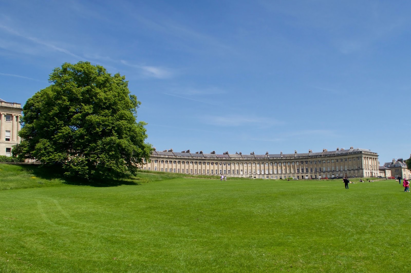
The Crescent, Bath
We eventually came in sight of Bath and walked through the suburbs along a variety of trails and paths.  The route passed beneath the Georgian Crescent and into the town center, finishing in front of the Abbey.  

The Abbey, Bath
The crowds of people in Bath were a little too much for us so we didn't stay around too long.  A beautiful city but too crowded with tourists at this time of year.

There are some more photos here


Tuesday, May 15, 2018

Serbia, Montenegro, Albania - May 2018

Another quick side trip on my way back to the USA from the UK.  I flew from Gatwick on Tuesday morning, 8 May, first to Amsterdam and then on to Belgrade in Serbia.  I arrived in the mid-afternoon and took a taxi into the city and my hotel, the Belgrade City Hotel. Since this was a quick trip and I was leaving the next day I immediately set off to explore the city, or at least that part of the city I could walk to from my hotel.  
Belgrade
The city is a little shabby, there are some quite modern buildings but there are a lot of older buildings some quite grand but some of them are in a state of disrepair.  Also the graffiti taggers have been at work and the town is peppered tags, most of them quite crude. I do appreciate and seek out good graffiti but this stuff is just a blight on the city.
Tesla's High Voltage Discharge
The Nikola Tesla Museum was close by so I went in and joined a tour.  It is not a particularly good museum and the exhibits are rather poor but the Serbs are obviously quite proud of their most famous scientist even though he did most of his work in the USA.  Apparently he only spent 31 hours in Belgrade during his life.  There were some fun demonstrations of high voltage spark discharges and the illumination of neon bulbs.  His suit and hat and other artifacts were on show too but not too impressive. I didn’t know but he was quite obsessive about germs and didn’t like to shake hands without gloves.   He was also obsessive about the number three - he liked to walk around buildings three times, he counted steps and liked to finish on a multiple of three, he only took hotel rooms that were a factor of three.
Orthodox Church
Continuing on there as a nice park with a statue of some unknown past hero and a nice Orthodox Church.  Shame I didn't have a guide book at this point. What was quite noticeable was the number of people in the parks. Parks were full of parents with their children.  You would never see such a thing in the US or even the UK.

Joe Strummer Mural
I continued my walk around Skadarlija, the so-called Bohemian district.  It was a little funky with lots of bars and restaurants perhaps Bohemian.  There were a few better quality grafitis or wall art. A fine portrait of Joe Strummer and similar ones of people I do not know.  
Sava River (left), Danube (top and right)
Continuing further on I reached the medieval fort area of Kalamegdanska.  The extensive walls and fortifications to the fort sit in a park area above the confluence of the Sava and Danube Rivers.  Again there were lots of people sitting around enjoying the evening and of course lots of children playing in the parks. There was a collection of armaments in the grounds all the way from early cannons, to WWI and WWII field guns, up to SAM missiles.  The latter really looked scary and out of place in such an old historical area.


I headed back towards my hotel and the nearby train station.  I had to pick up my train ticket at the station’s Western Union office.  As promised the lady in the office had an envelope with my ticket and the schedule for the next morning’s train.  As I walked through the quite dilapidated station I recognized it immediately. I had been there in 1971 on my way to Istanbul.  It hardly looked any different. I think perhaps I spent the night on a bench there. What a tremendous feeling of nostalgia. I was traveling with two ladies from Edinburgh University - I can’t even remember their names.
Belgrade Train Station
The next morning my train to Podgorica was scheduled to leave at 09:10.  It was the only train on the station, a shabby and graffiti plastered thing.  An old electric locomotive and 5 coaches one of which was a restaurant car. My coach was quite comfortable and I selected a seat with the cleanest windows though really all the windows were pretty filthy.  My seat had a top window that was one so at least I could get a clear view from that. The train left a couple of minutes early and we were on our way with only about 10 other folks in my carriage. Not a money maker for Serbian Railways.
The Belgrade to Bar Train
The train passed through the suburbs of Belgrade along a disheveled track - overgrown and every concrete surface emblazoned with graffiti.  A few miles out of the city we passed the train shed for what was Tito’s personal train. The three engines looked impressive but even they were covered in graffiti.
Tito's Private Train
The line was started in the 1950’s but it wasn’t completed all the way to Bar on the coast until 1976.  It is 296 miles long and has 254 tunnels and 435 bridges. In the early days it took 7 hours for the trip but now because of speed safety restrictions on the track it takes 11 hours.  Various parts of the track were bombed by NATO during the war.
Serbian Countryside
As we passed into more rural areas the landscape changed to grassy agricultural land and lush forested areas.  Somewhere on the way we cut across a corner of Bosnia-Herzegovina but there was no recognition of it and the train does not stop there.  As we left Serbia customs officers passed through the train to check documents and stamp passports. Similarly Montenegran officials checked us on arriving in Bijelo Polje the first Montenegran town.  A pretty straightforward border and efficient border crossing.
Montenegro

Montenegro


The final stretch of the line in Montenegro was the most spectacular section.  We crossed the Mala Rijeka viaduct, the highest and longest on the line, just after Bijelo Polje.  Then the track followed a steep 25% downgrade from high up on the side of the valley. What an amazing construction feat this must have been.  We started way up high on the side of a deep valley cut into the limestone mountains and descended with squeaking brakes through a series of tunnels and bridges down to the same level as the road as it entered Podgorica.
Station in Podgorica
We were some 5 minutes late which is not bad for an 11 hour trip.  At the station in Podgorica most of the passengers left the train. On the platform, exactly as expected, was my driver holding a sign with my name.  I had pre-arranged a car to take me to Tirana that evening. As we left Podgorica darkness was falling and it started to rain.


I didn’t notice much about the drive other than the driver was very careful to observe the speed limit.  Perhaps the police were really strict in that area. The other noticeable thing was the frequency of roundabouts, it was continuous, one after the other, it seemed like there was not a continuous stretch of road for more than a mile.  We arrived at the border with Albania in the rain. There was a short wait and a brief check on the passports on the Montenegran side, then another short wait to enter Albania. The once closed country is now quite open and welcoming.


The road into the capital, Tirana, was not particularly impressive - not a major highway.  My driver used his GPS to deliver me to my hotel - the Hotel Austria. A modern hotel in a backstreet area near the center of town.  We arrived around 11:00 and I was tired after 11 hours in the train and 3 hours in the car.
Skanderbeg Square, Tirana
Next morning I was up reasonably early and set off to explore the city.  It isn’t a very big city and the major sites in the center can be walked quite easily.  There was the Skanderbeg Square with its statue of Skanderbeg the Albanian national hero on horseback, the National Museum facing the square, the oldest mosque in town - Et-hem Bey Mosque, a clock tower, a Catholic Church, a huge modern Orthodox Church, an even larger mosque in the process of being built and then the infamous pyramid of Tirana.  The latter is a monument to the now much despised dictator Enver Hoxha designed by his daughter and which was once the most expensive building project in Tirana. It is now in disrepair and is covered with ugly graffiti. Apparently they can’t decide what to do with it - destroy it or keep it as a reminder of those desperate days.
Skanderbeg Statue

The Tirana Pyramid
I covered all those sites in a couple of hours before breakfast.  After breakfast I took a taxi out to the Bunk’Art museum. This is an old bunker complex out of town built in the 1970’s as a site to protect Hoxha and his government if someone attacked Albania with nuclear weapons.  It is an immense complex with hundreds of rooms, an auditorium, protective air locks, explosion proof doors. While in the 70’s, we, in the rest of the world, were not thinking much about that nuclear attacks, in Albania they were preparing for the worst.  I had the the place to myself - there aren’t many tourists here. Nevertheless the museum provided a most informative history of what happened during the period from just before WWII up to the end of the Communist era. And fortunately there was an English translation for most of the displays.  The best museum
Bunk'Art entrance

Bunk'Art Bunker Corridor
Walking back towards town I got another taxi to the second Bunk’Art museum which is close to the main square.  This one Bunk’Art 2 deals with the police and security forces, the Sigurimi, in Albania from WWI up to the terrifying period of the Hoxha regime.  The Sigurimi were not a force to be trifled with. This museum is also housed in a bunker complex below the city streets.


At that point it was nearing 1:00 pm and I was feeling like I had walked enough.  My flight was at 3:30 so I took a taxi to the airport, Mother Theresa Airport (she was Albanian). Taxis do seem quite reasonable here.  At the airport all was smooth for my WizzAir departure for Budapest. Interestingly my ticket for the flight was 27 Euros.  If I hadn’t have printed my boarding pass at the hotel that morning, I would have been charged 35 Euros to get a boarding pass at the airport.
Mother Theresa Airport
EasyJet from Budapest to Gatwick and an overnight stay at the very fine Bloc Hotel before my Norwegian flight to Oakland and home.

There are more photos of the trip here.

Monday, May 14, 2018

Three Peaks Challenge - May 2018

It all started when I paid a visit to my friend Peter Kirton in London.  He suggested that I join him and his three sons on a “Three Peaks Challenge” that his son Akira was arranging.  The idea is to climb the highest peaks in Scotland, England and Wales in one weekend. Starting in Edinburgh, we would drive to Fort William for Ben Nevis the highest peak in Scotland (4,413 ft), then drive to the Lake District to climb Scafell Pike (3,209 ft), the highest in England, and finally finish up with Snowdon (3,560 ft), the highest in Wales.


It sounded like a nice thing to do so I agreed.  Over the next few weeks however I felt more and more unsure of things, Ben Nevis is the highest of the three and it is cold up there and there is snow.  


On the Friday afternoon I flew from Gatwick to Edinburgh to meet up with everyone and we all set off in a couple of rented vans.  There were 22 of us, mainly friends of Akira’s, predominantly fellow parents from his children’s school. We drove north from Edinburgh into the highlands, stopping for a bite of food on the way in Doune (totally overwhelming the staff at the pub who were not set up for an onslaught of 22 people in one go).  


At Fort William we had rooms at the Nevis Bank Inn.  The arrangements were a bit loose and we all shared rooms and most people had to share a bed.  I was fortunate as I shared a 2 bed room with Peter and son Hugh and I got my own bed.


In the morning after herding everyone out after breakfast (not an easy task) we set off for the mountain.  Since conditions on Ben Nevis can vary rapidly and the forecast was not good, Akira had arranged for a guide.  Not something I would generally do but in retrospect with 22 people many of whom had little prior mountain experience it was a good idea.
The Group before Ben Nevis
The trail from the Ben Nevis Inn is a well maintained route along the side of the mountain but it is up all the way.  It is built to last with huge boulder steps for most of the way up the lower slopes. Whoever built and maintains the trail did a fine job.  
Lower Slopes of Ben Nevis
On the lower slopes we were below cloud level and we could not see the top - it was shrouded in clouds.  It was pleasantly cool but not cold walking up the lower slopes and the fine rain that had been with us at the start fortunately stopped as we got higher.  There was some nice scenery with a couple of lakes and a view of the loch at Fort William below (Loch Linnhe). As we moved into the clouds we started up a series of long and steep switchbacks.  At the top of these we had reached snow level. There was a bit of a tough scramble in the snow up the last steep rise before the trail leveled out and sloped more gently towards the top. I used my crampons on this last bit since I had carried them all the way up but you could certainly manage without them.


This top section is where things could have gotten tricky without a guide, the clouds were low, the visibility poor, and the wind was fierce and somewhere out there there was a drop off down the steep side of the mountain.  
We finally reached the summit - a concrete trig point, a stone shelter and a weather station.  Of course we weren’t the only ones up there. It was terribly crowded with over a hundred people milling around taking photos and congratulating each other.  We did the obligatory summit team photo and munched on Hob-Nobs before starting our descent.
The Group on the Summit

Yours Truly on Summit of Ben Nevis
On the way down we did get a clearer look at the drop off down the steep side and it was very near to the summit trail.  That is definitely where things could have gotten nasty.


The way down was much easier for me.  When I am not limited by my breathing and gravity I find I can move a lot more quickly.  In fact I like to jog down a bit, it seems to be easier on the knees and quads.


At the bottom there was a pub where we all had snacks and beer while we waited for everyone to get down.  Then it was in the vans for the long drive south.


We drove through much of the same route that we had taken in the dark the previous night and we got the chance to see how beautiful it really was.  It was my first time in the highlands and they didn’t disappoint.


We picked up a couple of more people in Glasgow who were joining us for the last two peaks and then continued south to Lockerbie where we were staying for the night.  We finally arrived at the hotel around 9:00 pm and got the last orders in for a meal in the restaurant. For whatever reason I lucked out on the rooms and got one to myself.  It was a very small double bed with one side against the wall, not the sort of room to share a bed with another person.


Next morning our friends John and Gabrielle, who live an hour away in Kirkcudbright, joined us for breakfast.  I had seen them in Idaho for the eclipse the previous year but it had been many years since Peter had seen them.


Moving on south we drove into England and around the west side of the Lake District to the trailhead for Scafell Pike in Wasdale.  The weather was much better - sunny, warm, blue skies. A perfect day for a hike.
Wastwater from bottom of Scafell Pike Trail
My legs were certainly sore from the previous day’s efforts but I eventually got adjusted to climbing again.  The route from Wasdale is the shortest way up the mountain, being only 2.5 miles each way. Of course that makes it the steepest and it was a relentless slog up the side of the hill.  The lower 75% was a well maintained trail but at the top it became more of a slog through boulders and scree. Not easy going at all.
The Group on Scafell Pike
There were lots of people on the summit - a Bank Holiday weekend and the promise of good weather really brings everyone out.  Again after summit photos and celebrations we started down the hill. The downhills were becoming more painful now and my quads were really burning.
View from Summit of Scafell Pike

Wastwater from Scafell Pike Trail
At the bottom of the trail was a pub in Wasdale and a refreshing pint of shandy was just what I needed.  Then it was onwards for the long 4 or 5 hours drive into Wales to Snowdon. Again we drove through some stunning countryside a lot of it new to me.  Along the west and southern edges of the Lake District then as it got darker we were on the north coast of Wales (the Dee estuary, Rhyl, Colwyn Bay) before we turned down towards Caernarfon.


Since we were so late the restaurant we had planned to eat at declined to wait for us we had to find another place to eat.  We settled on an Indian in Caernarfon. It got a bit boisterous after the long drive and the consumption of alcohol but our Indian hosts did a great job of putting up with us and serving us some fine Indian food.


We arrived quite late at our hotel, the Saracen’s Head in Beddgelert.  After two nights of my own bed, I finally had to share a bed with Peter.  It was large enough and fortunately his snoring wasn’t too bad.


The next morning I wasn’t moving very well at all.  The stairs in the hotel were difficult and left me out of breath, how was I going to climb Snowdon?
View of Snowdon from Trailhead
There are many routes up Snowdon but we chose the Pyg trail out of the Pen-y-Pass car park on the way up, with a return on the more gentle but longer Miner’s trail.  The trail as usual was very well maintained for the most part. Lots of big boulder steps that tested you going up and going down.
Snowdon Summit
Snowdon is perhaps the most spectacular of the three mountains given that Ben Nevis was in the clouds.  It is a real mountain and you can clearly see the peak as you ascend. The views as you ascend are simply wonderful and the day was perfect, blue cloudless skies and quite warn.  As you climb out onto the summit ridge you join the railway track of the cog railway from Llanberis. There can’t be many mountains where you summit to a railway station and a cafe.
The Snowdon Cog Railway

Snowdon Summit Photo
After the obligatory summit photos we adjourned to the cafe for huge Welsh Pasties and cold Coca Colas.  Perfect.


The descent down followed the same route as we took going up and then the Miner’s Trail turned off downhill on a very steep section for about ¼ mile before leveling out for a gentle walk along the side of a lake and then down to the parking lot.  I took a most refreshing paddle in the icy waters of the lake. Just what the feet and calves needed. Some hardier folk like Akira and Ken took a swim in the lake. That would have been too cold for me.
Down Miner's Trail, Snowdon
The final mile back to the trailhead is a most pleasant walk. Nothing steep, just a gentle descent with a well placed pub at the bottom provided the necessary refreshments.
Lower section of Miner's Trail, Snowdon
So there it was, three peaks in three days.  That was quite an achievement and I don't know if I need to do that again.  Everyone was calling it the “Three Peaks Challenge” but I later learned the true Challenge was doing what we did in 24 hours.  That seems a little extreme, but lots of people do it apparently.


It was then a 5 hour drive back to London where we distributed people around Windsor and Heathrow and said our goodbyes.  I caught the bus from Heathrow to Gatwick where I had a hotel for the night.

There are more photos here.