Friday, July 17, 2020

Tahoe Rim Trail - Part 1

In these times of self isolation and inability to travel I turned back to hiking and trail running.  One of the things I have been wanting to do for a long time was to complete the circumnavigation of Lake Tahoe on the Tahoe Rim Trail.  The TRT is a 165 mile trail primarily along the crest of the mountains surrounding what is truly one of the most beautiful lakes anywhere.  I had hiked bits of the trail before but these days I don't like to carry a back pack for too far or for too long, so running the trail seems like a better option.  I did trail runs on the eastern side of the lake a couple of years ago and the only bit I had left to do was the western side through the Desolation Wilderness and Granite Chief areas and a bit of the northern edge near Mount Rose.  At the end of June I decided to get serious about it so what follows are descriptions of several runs to complete this endeavor.

Tuesday, 30 June - Echo Summit to Dick's Pass
Since the best part of the day is the early morning before things get too hot, I set off at the ridiculous hour of 4:15am to drive up to Tahoe.  I arrived at Echo Summit just before 6:00 am and parked in the Echo Lake parking lot.  I was on the trail just after 6:00 and received some strange looks from the early morning anglers fishing off the bridge that spans the outlet from the lake.   I am sure we both thought the other was crazy for being there at such a ridiculous hour with such a ridiculous pastime.  
Echo Lake
Echo Lake
The first part of the trail runs above the east side of Echo Lake.  Echo Lake has cabins along its shores, quite nice cabins too and not all that primitive, some were quite well appointed.  I was feeling quite pleased with myself at having got so early and I really enjoyed the run alongside the lake.  The trail was a bit rocky and it does gain in altitude but it was not too difficult to run on.  The views were spectacular with the lake and Mt Ralston and Pyramid Peak in the background.
 
In normal times there is a boat service that takes you between the southern end of Lower Echo Lake through the narrows to the northern end of Upper Echo Lake.  That would have save me a couple of miles on the way back but in these coronavirus days the boat service is not running.  
Lake Aloha
After passing Lower Echo Lake and the smaller Upper Echo Lake the trail skirts the side of the hill past Tamarack Lake and through Haypress Meadows before dropping down past Lake Lucille and Lake Margery to the Aloha Lake basin.  Lake Aloha is a spectacular lake - quite large and almost above the tree line so it presents nice wide open views along its shoreline.  It is a very popular camping spot for day trippers from Echo Summit and for PCT through hikers.
Lake Aloha
This section of the Tahoe Rim Trail is the same path as the Pacific Crest Trail so it is a major trail and difficult to get lost on (that being said I did get off trail twice on the way back when I wasn't paying attention).  After leaving the Lake Aloha basin the trail drops slightly to skirt Heather Lake and Susie Lake before once more starting to rise again.  By this time I had done over 10 miles and while I wasn't feeling too bad I knew things would be getting worse for the way back.  Still I was within a few miles of Dick's Pass so I decided to push on and make it a longer day.  Dick's Pass would make a good point to approach the trail from the other direction when I came to do that section.
From near Dick's Pass looking south
The climb up to Dick's Pass was quite arduous and seemingly never ending.   The reward at the pass was magnificent views down to Dick's Lake and the mountains to the north and even more magnificent views back down the trail towards Half Moon Lake and Lake Aloha.  My starting point at Echo Lake was at an elevation of 7400 ft and Dicks Pass is at 9400 ft so that was 2000 ft of climbing.  The air was certainly a little thinner up there and it was blowing a little cooler.  
Dick's Pass - 9400 ft
At the time I didn't know who Dick was but he certainly did quite well in that area with a mountain - Dick's Peak, a pass - Dick's Pass and a lake - Dick's Lake named after him.  I later found out that he was Captain Richard Barter, an Englishman, a sea captain, whose nickname was the Hermit of Emerald Bay.  He was hired as caretaker of a villa built on Emerald Bay and he had quite the hard life living alone during the long winter months in the villa.  Boat access was the only way in and out of the villa in winter and on one of his trips to South Shore he capsized and drowned.  His story is told here.

I didn't hang around at the pass for too long as it was getting late.  I was at 13.5 to 14 miles at that point and I knew it was going to be a tiring run back.  The real problem was that not much of the trail was easily runnable.  It was a rubbly and rocky trail that didn't lend itself to running even on the downhills.  As a result progress was slow.  

I did get off on the wrong trail a couple of times.  That was hard to do but I guess I just wasn't paying attention.  I did correct it of course but an extra mile or two was not what I wanted.  There were some dark periods in the middle of the way back when I just wanted to sit down and rest for a while but I really couldn't afford to.   My mood lifted once I got back to the Aloha basin and things started moving a little easier.
Lake Aloha on the return
That being said, the last few miles were certainly more of a walk than a run but I managed to make it back around 6:00 pm and my phone said I had done 29 miles.  A good day but it did take me 12 hours to do it so that is not all that fast.  It was enough for one day though and I was very relieved to see the car again and have some proper food.  

That night I spent in North Shore where Nancy had a condo rented for a couple of days. 

Thursday 2 July - Barker Pass to Rubicon Trail
Feeling more or less recovered I decided to do a short section of the trail before I left Tahoe on the following Thursday morning.  This was an out and back section, 4 miles out, 4 miles back from Barker Pass south to the point where the Rubicon Jeep Trail crosses the trail.  
Barker Pass Trail Head
From lake level the Barker Pass Road goes up to the summit and is a nicely paved road much favored by cyclists in need of some hill work.  Since the road stops just after the summit there is little traffic on the road except for hikers gaining access to the PCT and TRT and so it is perfect for cyclists.
South from Barker Pass
The hiking trail south from the trailhead is nice and easy going.  Gently down and gently up but nothing too severe.  After the previous rocky trail by Echo Lake and up to Dick's Pass it was a joy to be able to run on smooth dirt trails.  The scenery here is not spectacular as nearly all the way it was in the trees so there was no view out over the surrounding countryside.   However being in the trees it was nice and cool.

I polished off the 8 miles in a couple of hours and was back in the car before lunchtime and down the hill to Sacramento by mid afternoon.

Sunday, 5 July - Dick's Pass to Phipp's Peak via Bayview Trail
0n the next Sunday morning it was another early start for the Tahoe area.  This time to pick up where I left off at Dick's Pass earlier in the week.  Of course that was not such an easy thing to do as I had to get into the Dick's Lake basin by going up the Bayview Trail from Emerald Bay on the side of Lake Tahoe.  That is a climb all by itself and at least 4 or 5 miles.  
Emerald Bay, Lake Tahoe from Bayview Trail
So I was out of the house around 4:00 am and I arrived at the Bayview Trailhead on Emerald Bay around 6:00.  The trail affords wonderful views of Lake Tahoe but it is quite brutal in its ascent.  It is the best part of 2 miles of switchbacks up the side of the hill.   On top it was a mostly gentle downhill runnable section to Dick's Lake and the start of the trail up to Dick's Pass.   The trail up to Dicks Pass from the north side is a lot better than coming up from the south.  It is a series of gentle, mostly runnable, switchbacks up to the top.  The pass is at 9400 ft and my starting point on Lake Tahoe was around 6300 ft.  So that is 3100ft  of gain - quite a climb.
Dick's Lake
The descent down from Dick's Pass was just wonderful - gentle downhill with a nice smooth footing.  The trail drops down to Dick's Lake and then skirts around the edge of Fontanillis Lake which in my opinion is on of the more beautiful lakes in the area.  The trail then drops down to Middle Velma Lake.  This area again is a popular camping spot for weekend backpackers as well as for through hikers. 
As I was feeling fairly good I decided to go a little further so as to make my next section a little shorter.  I headed past Middle Velma Lake and on towards Phipps Peak.  It was a gentle climb up towards Phipps Peak and when I reached the junction with the trail up to the peak (and on to Meeks Bay) I turned around.  
Near Velma Lakes
The way back was  a little shorter as there was a cutoff over to the Bayview Trail.  It was a relief to finally reach the top of the Bayview trail knowing that it was all downhill from there, albeit a steep and long downhill.   At the end of the day my phone told me I had done 18.5 miles.

Thursday 9 July - Barker Pass to Tahoe City 
Having recovered from Sunday's run, I decided to have another go at the trail.  This time I tackled the section from Barker Pass to Tahoe City.  This section is 16.7 miles so an out and back would just not be doable by me.  Fortunately my friend, George Troy was up in Tahoe and I persuaded him to pick me up when I had finished and take me back to my car.  
Sunrise over Lake Tahoe
For some reason I was awake early on Thursday morning (at 2:30) so I decided to get an early start.  I was at the trailhead at the summit of Barker Pass Road by 5:00 am and it was still dark.  By the time I had got sorted out and ready to run there was just enough light to guide my way so off I went.  This section is predominantly downhill.  Barker Pass is at 7650 ft and the end in Tahoe City is 6300 ft.   
View to the South West from TRT

Beautiful trails for running
It was an enjoyable run too.  Nice views over into the Granite Chief area before the Tahoe Rim Trail splits off from the Pacific Crest Trail and drops down into the Tahoe Basin.  After some lovely downhill trail sections the trail joins Ward Creek Road and follows it for a while before climbing up to Page Meadows and then finally dropping down to Tahoe City.
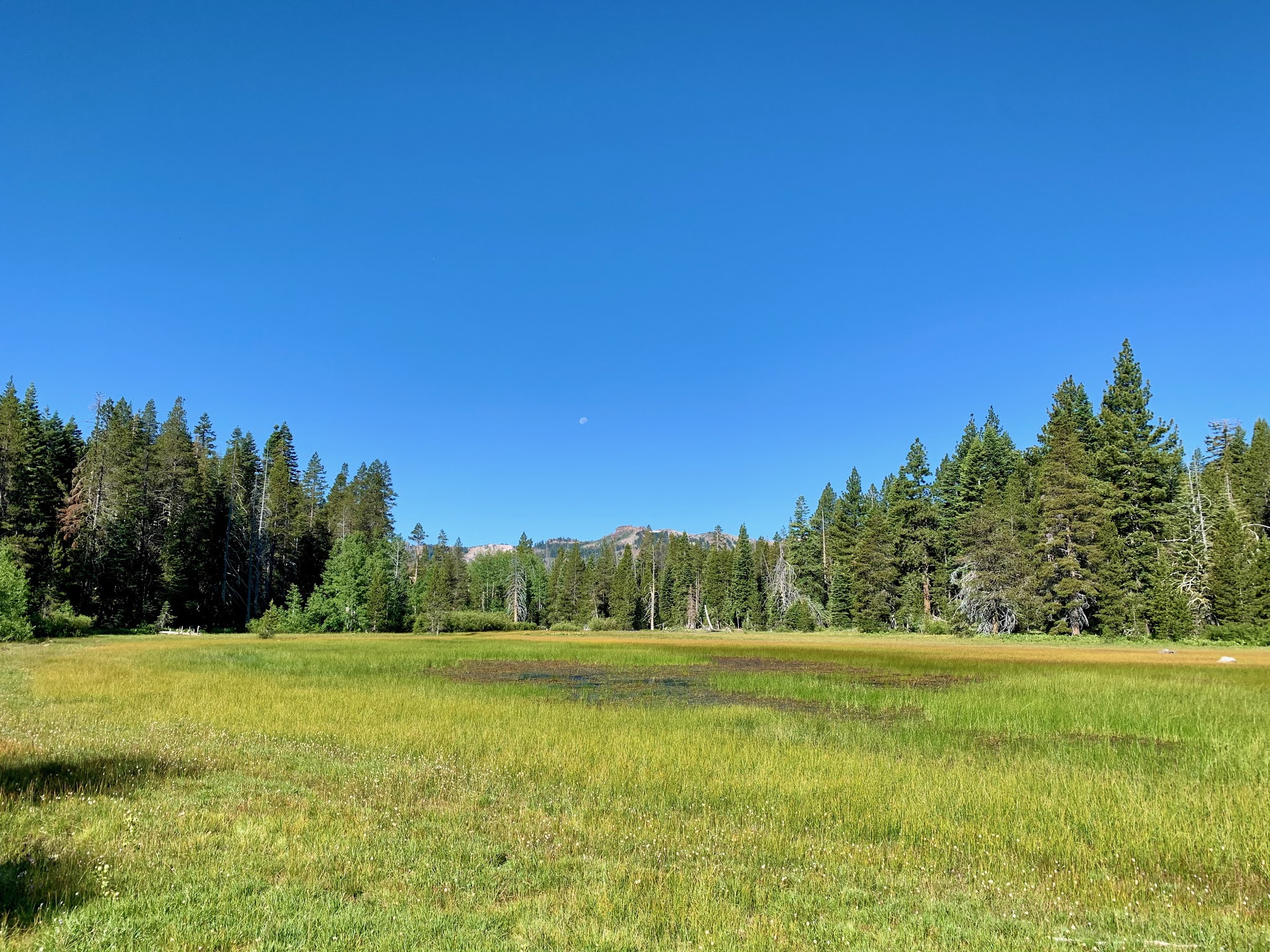
Page Meadow
After all the rocky trails encountered around Dick's Pass and Lake Aloha, this trail was just beautiful - smooth for the most part, shaded, slightly downhill.   What more could you ask for.

I arrived in Tahoe City on the banks of the Truckee River where there were literally dozens of rafters floating down the river.  Six or eight people in a raft with not much social distancing going on.  I made a call to George and he came and picked me up and drove me back up the hill to the car.  I was done by 10:00 am, back at the car by 11:00 and back down in Sacramento by 2:00.   A great day.


Saturday, February 29, 2020

Bleaklow, Pennine Way - February 2020

In February I went up into the Peak District to go for a run and I found myself heading towards the Dark Peak and the Snake Pass.  It was a beautiful morning and as I drove past Ladybower Dam there was a bit of low mist hanging over the dam and it looked beautiful if a little cold.
Ladybower Dam
I parked the car where the Pennine Way crosses the road and set off northwards on the trail towards Bleaklow.  This is one of the most well known trails in the UK stretching from Derbyshire up to the Scottish Borders. It is a fairly popular trail and even at this early hour on a weekday in February there were several cars already parked at the trail crossing.  It was quite cold and the ground was frozen which made for a nice solid footing despite the occasional ice that could be a little treacherous.
The Pennine Way north from Snake Pass
The trail crosses fairly difficult terrain being a peat moorland with frequent drainages that cut through the peat bogs.  That being said the trail is very well maintained and it forms an easy path through the moor. I was surprised to find some sections paved with massive flagstones.
Paved Trail
 I had heard of the many aircraft wreckages in the Peak District and I knew there was one nearby this section of trail on a hill called Higher Shelf Stones.  I decided to take a look and so a couple of miles or so up the trail I headed off trail to the nearby summit of the hill. Leaving the trail it then became clear what a difficult terrain this moorland is to navigate.  A low brush of heather and grasses cut by drainages with muddy swampy bottoms.
Higher Shelf Stones
The plane wreck on the top of Higher Shelf Stones was of an American B-29 Superfortress.  Quite a big plane, same model as the Enola Gay which dropped the atomic bomb on Hiroshima.  It crashed in November 1948 while on a short 25 minute flight from Lincolnshire (Scampton) to Liverpool (Burtonwood).  It was apparently very foggy and they must have been very unlucky as the crash site is right at the top of Higher Shelf Stones which itself is not a particularly high mountain.  Anyway all 13 crew members were killed and the wreckage was strewn over the top of the hill. 
The Crash Site
I was surprised how some 72 years later there is still a lot of wreckage at the site.  Lots of aluminium body and then the more massive engine pieces. It was strange to see so much metal just lying around at the top of the hill.  There was a marker identifying the site on a metal plaque and there were signs of recent memorials with a group of red poppies and small wooden crosses.  Apparently every year there is a small memorial service at the site.  
Memorials at the Crash Site
There is no significant pathway to the site as far as I could see.  It just requires a scramble up the side of the hill. On the way back down I took a slightly different route down towards the Pennine Way Trail and rather quickly got disoriented in the bottom of a gully.  I knew that somewhere to my east I would encounter the trail but it just goes to show how quickly one could become lost up there even on a clear sky day.
View over the west side of the hill
Looking back at the hill of Higher Shelf Stones you realize that the crash site was so close to the top of what is really just a very modest hill.  It must have been very unlucky for an aircraft to hit near the top.  If they had been only a few feet higher they would have been looking down onto the valley and Manchester below.

Once back on the trail I turned back south to the road and to my car.  One of these days I should do the entire way but that is 268 miles and I am not sure I am up for that anymore.

Friday, February 28, 2020

Beverley, Yorkshire - February 2020

In February my step sister, step-sister in-law and myself met for lunch in the small Yorkshire town of Beverley.   I had never been there before and was surprised to find it had a lovely old town center with not just one but two magnificent churches, Beverley Minster and St Mary’s Church.  The town was obviously much more significant in its past than it is now and apparently in the Middle Ages it was the 11th largest town in England.
St Mary's Church, Beverley
I parked in the Market Square and went over to the nearby church thinking it was the Minster because it was quite large and impressive.  I was however informed that it was not the Minster but in fact St Mary’s Church. The Minster, which is even bigger and more impressive, is on the other side of the town.  St Mary’s though is a wonderful church and I spent some time wandering around inside. There are some beautiful stained glass windows dating from the Victorian era. A ceiling painted with the constellations of the stars.  Beautiful carvings in both wood and stone. Particularly interesting was a colorful carving of a group of minstrels on one of the columns. Apparently the Guild of Minstrels had its northern headquarters in Beverley back in the day.
Interior, St Mary's Church

The Minstrels in St Mary's Church
I also learned a bit more about misericords.  I first came across them on my recent visit to Manchester Cathedral but there were some more nice ones in St Mary’s.  The name sounds to me more like a piece of music or an incantation but a misericord is a type of folding seat in a choir stall that can be folded down to provide a rest for clergy and choir while they appear to be still standing.  Most essential for a long church service. The other unusual thing about misericords is that they have carvings on the underside of the seat. Often not religious but more whimsical.
Misericords
One thing that I didn’t pay much attention to was the Memorial Door, a carved wooden door by the quite famous Robert “Mouseman” Thompson.  Another carved object I missed was the 1325 carving of a rabbit in the Sacristy door that allegedly was the inspiration for the illustrations of Lewis Carroll’s Alice in Wonderland.  It's a shame I didn’t read the guide book more carefully when I was in the church.
Beverley Minster
The ornate entry to the Minster
The Minster which I visited after lunch is even larger and more impressive than St Mary’s.  It’s exterior is quite ornate with a beautifully carved doorway. Inside the nave is immense and there are so many intricate and ornate carvings.  Where did all these craftsmen come from and who can do this kind of work these days? There is an organ with ornate painted pipes; the choir stalls and chancel has the most remarkable wooden carvings; there are Misericords here too and they have carvings on the underside of the seat, but not as impressive as those in St Mary’s.
The Altar and Reredos
The altar is relatively modest but behind it there is a screen of beautiful carvings.  I believe they call this a reredos. Down one side there are a series of small sculptures of musicians - perhaps again something to do with the Guild of Minstrels.
One of the many Minstrel Carvings
What a beautiful town Beverley is with its lovely old town center and its two fine churches.  It even has a racetrack (for horse racing). Well worth a visit.

There are more photos of the churches here.

Tuesday, February 25, 2020

Belfast, Northern Ireland - February 2020

River Lagan in Belfast
I arrived in Belfast on the train after spending a couple of days in Dublin during February of 2020. From the Lanyon Place Station it was a short walk to my hotel, the not at all bad Malmaison Hotel.   On the way over to the hotel I walked past the St George’s Market. An old market with a wonderful old facade which still operates today though perhaps more as a tourist destination being only open at the weekend.  From there I crossed to the banks of the River Lagan and the very modern Waterfront Hall.

St George's Market
After checking in there were a couple of hours of daylight remaining so I went out to explore a little.  Just up the street from the hotel was the impressive Albert Memorial Clock. One of many Victorian edifices in the UK and Commonwealth commemorating Prince Albert.  Nearby is "The Big Fish", a ceramic tiled fish on the side of the Lagan. The blue tiles depict elements from Belfast’s history.
Albert Memorial Clock

The Big Fish

Titanic Museum and one of the H and W Cranes
Across the river you could see the new Titanic Area with its impressive new Titanic Museum building and the even more impressive Harlan and Wolf shipyard (where the Titanic was built) with its massive, but no longer used, big yellow cranes, Samson and Goliath

Walking further out to the north on the west bank of the Lagan there is a fair bit of new development going on. Old warehouses converted to apartments, shiny new office buildings.  In my youth I never heard anything positive about Belfast.  It was the time of “The Troubles” and nothing would make you want to come here.  Now I see lots of signs of a thriving city.  
The Merchant Hotel
I walk through the main shopping area of town over to the City Hall which is a most impressive building.  Victorian era and quite magnificent. The surrounding buildings in the adjacent streets are also impressive and show that even then this was a major city.  For dinner that night I stop into one of the finest looking old hotels I could imagine, The Merchant. A truly majestic building with a beautiful old interior that I learned was built as the headquarters of the Ulster Bank in the mid 1800's and then only in 2006 converted to a hotel.  I went inside sat in the ornate bar for a drink (quite expensive) and then moved over to the even more ornate dining room for dinner (quite reasonable).
Belfast Cathedral
Next morning I was up early and out to again explore the city.  The Albert Memorial Clock again, the Custom's House, and Belfast Cathedral. Then over towards the Victoria Square shopping center.  Just outside the shopping center is the Jaffe Memorial Fountain, an unusual and out of place object that was erected by an Otto Jaffe a German Jew who emigrated to Belfast in the mid 1800’s and who eventually became Mayor of the city.  It is a memorial to Otto’s father who died in Nice but whose body was shipped to Belfast for burial, the first Jew to be buried in Belfast cemetery.

The Jaffe Memorial Fountain
The new Victoria shopping mall is just the same as all the others in the world today with all the same shops you get in England.  The shopping mall does have one redeeming feature however, an impressive viewing tower above the mall that you can climb up to and view the surrounding city.  That is worth a look for sure.

Belfast City Hall
Further up the road is the City Hall again and this time it is open, at least partially.  The interior is just as spectacular as the outside and there was a nice exhibition about the city, its history and its people.  
The Grand Opera House
On Great Victoria Street there is the Grand Opera House.  Well known to all Van Morrison fans as it is pictured on the cover of his live album recorded there.  It is a beautiful building. 
The Crown Liquor Saloon
 Just across the road is the Crown Liquor Saloon.  A magnificent example of an old Victorian pub or gin palace.  The pub has wonderful tile, stained glass and woodwork. It is actually owned by the National Trust but it is still operated as a pub.  I should have stayed for a drink but perhaps not at 10 in the morning.

Back on the other side of the street is the Europa Hotel.  This fairly recent 1970’s hotel has the dubious reputation of being the most bombed hotel in the world having survived 36 bomb attacks during “The Troubles”.
Clifton House
I checked departure times for the airport bus in the adjacent terminal and then set off to walk some of the neighborhoods.  Due north of the Europa is the Clifton House a fine example of Georgian architecture. Then just beyond this I found myself in the New Lodge area.  This, as I remember from my youth, was an ardent Republican area and even today there is no confusing it as anything but that. The murals on the walls, the graffiti, the flags flying and the memorials to casualties of the conflicts all identify the place as a fiercely Catholic Republican area.
New Lodge Mural

Wall murals have become a significant part of many neighborhoods in Belfast.  I don’t know if they started with the troubles but they all seem to be related to that period and they are often quite militaristic.  In addition to the murals there is the odd piece of recent graffiti stating “Britain out of Ireland” or “End Forced Strip Searches” or “Join Saoradh”.  I thought "The Troubles" were diminished since the Good Friday Agreement but they are certainly not over and they are not being forgotten.
New Lodge Mural


New Lodge Graffiti
Walking down Antrim Road and then up the Crumlin Road you get to the Crumlin Road Gaol.   Again along with the nearby Shankhill Road and Falls Road are these are names from the news reports of the 60’s and 70’s.  I went in the Crumlin Road Gaol and took the tour. It was an interesting view inside a Victorian Gaol that was actually in use up until 1996 and housed many of the Republican and Unionist prisoners of “The Troubles”.  Eamon De Valera also was a prisoner there, as was Bobby Sands. 
Crumlin Road Gaol
Across the road from the Gaol is the Crumlin Road Courthouse; an impressive building that is now derelict and up for sale (with planning permission for a hotel conversion).  The Gaol and Courthouse are linked by a tunnel to facilitate transfer of prisoners between the two.
The Unionist Neighbourhood


South of Crumlin Road I get into the Shankhill area and this is a Unionist area.  Here the wall murals promote the British military and the ties to the Queen. The flags flown here are all Union Jacks.

After walking up the Shankhill Road for a while I turned south onto Cupar Way which was the location of one of the Belfast Peace Walls.  Walls like this were built to separate the Republican and Unionist communities in the late 60's early 70's. This one still exists today along the side of Cupar Way. It is covered with crude tagging.
Belfast Peace Wall
At the end of the Peace Wall it ran into the Falls Road and I was now back into Catholic territory.  Again here we had murals depicting the Republican point of view. It is here that there is the mural of Bobby Sands the Provisional IRA member who died on hunger strike in 1981 in Long Kesh Prison just outside Belfast.  Incidentally he was for some time in Crumlin Road Gaol and it is there where he was married in the Governor’s office (all a part of the tour).
Bobby Sands Memorial

By then I was tired of walking (over 10 miles according to the iPhone) so I took an Uber over to the other side of the river and the Titanic Museum.  On the way I asked the driver to locate the George Best mural. He was a Belfast boy and a brilliant footballer but he couldn’t handle his alcohol. I saw him once in Aberdeen airport in the 1970’s and he looked terrible.  Somewhere there is quite a large mural of George but we could only fins a small one. Still it was nice to see something not remembering or promoting the Unionist-Republican differences.
George Best
The Titanic area on the other side of the Lagan is part of a new development near the old Harlan and Wolf shipyards where the Titanic was built.  It has a new stadium and new office buildings and restaurants and of course the Titanic Museum. I walked around but didn’t go into the museum.  It looks a lot more interesting from the outside and I didn't really have the time.

The Titanic Museum
In dry dock near the museum is the White Star Line's Nomadic, the last remaining White Star Line vessel (other than the Titanic at the bottom of the ocean).  The Nomadic was used to ferry passengers from Cherbourg to the Titanic before it left on its fateful voyage, the Titanic being too big for the harbour at Cherbourg.
The Nomadic
That was the end of my tour of Belfast.  I walked back to the hotel, picked up my bag, and walked to the bus station for the ride to the airport and back home to England.


Monday, February 24, 2020

Dublin, Ireland - February 2020

In February I took a break from clearing out my mother’s house and escaped to Ireland for a quick look around the cities of Dublin and Belfast.  I flew from Birmingham to Dublin, on RyanAir of course, for next to nothing ($20). In Dublin a quick bus trip into town where I got the chance to be anxious about two Chinese looking tourists with face masks getting on the bus.  In these Coronovirus days people like that are noticed and wouldn’t you know they came and sat right next to me on the bus. I am sure I will be fine.

I was staying out in Dun Laoghaire, the passenger ferry port for Dublin, so from the center of town I got the DART train out that way.  It is a very nice journey out on the side of the bay to Dun Laoghaire, the train goes right alongside the water. My hotel for the night was the Royal Maritime Hotel, a nice old building housing what was once (and perhaps still is) a fine hotel.  It sits above the harbour and is perhaps one of the more impressive buildings in the town. That is with the exception of the fine new library, the dlr lexicon. This very modern building is just in front of the hotel by the harbour. 

The Royal Maritime Hotel
After checking in, I walked around the town which, to be honest, is neither large nor particularly attractive.  To escape the cold, I paid a visit to the National Maritime Museum of Ireland. Housed in an old church it is a collection of maritime artifacts and model ships (some of them in bottles).  It was interesting but, for such a seafaring nation, I found it a bit of an anticlimax. There was a presentation on the torpedoing of the Royal Mail Steamer, the Leinster, just one month before the end of the First World War. Some 501 people died onboard the vessel when it was hit by two torpedoes just outside the Dun Laoghaire harbor.  For the number of fatalities this sinking got very little attention.
The library and the church hosting the National Maritime Museum
Next morning I headed into Dublin again on the DART train.  In the city I decided to take the Hop on Hop Off tour. As I was leaving for Belfast in the mid afternoon, I did not have a lot of time so I did the whole tour without hopping on or hopping off.  I sat the entire time out on the back of an open top double decker bus under blue skies but really windy and cold weather. By the end I was chilled to the bone,
The Customs House
Despite the cold it was a good overview of the city.  We started in O’Connell Street and off we went… the Dublin writer’s museum celebrating the likes of Shaw, Beckett, Swift, Wilde, Joyce and Behan (quite an impressive collection of authors); the impressive General Post Office where the declaration of independence was read;  the Customs House; the very haunting Famine Memorial; the Georgian Merrion Square; the National Gallery; Leinster House, the seat of parliament; Grafton Street; Trinity College and College Green; Dublin City Hall; Christ Church Cathedral; St Patrick's Cathedral; the Guinness Brewery and Storehouse; the Museum of Modern Art; Kilmainham Gaol; Phoenix Park which is the largest urban park in Europe; and finally down the north bank of the Liffey past the Jameson Distillery to our starting point in O’Connell Street.   
Dublin Cathedral

Entrance to the Guinness Brewery


O'Connell's Statue on O'Connell Street
The trip was quite a lot to take in from the top of a bus but it served its purpose of giving me a great overview of the key sites in the city.  It must have been 15 years ago that I was last in Dublin (to run the Dublin Marathon) and I must admit I don't have much of a memory of the city or the marathon course for that matter.  I still will have to come back for a more leisurely look around the place.
The Samuel Beckett Bridge
After the bus trip I walked over to Connolly Station to buy a train ticket to Belfast.  I then had a couple of hours to kill before the train so I walked out to the Liffey and walked up the north side towards the Samuel Beckett Bridge.  This bridge is a modern one designed by Calatrava, the same man that designed the very similar looking Sundial Bridge in Redding, California.
The Famine Memorial
To the west of the bridge is the Famine Memorial which is a haunting group of statues commemorating the Irish Famine of the 1840’s and the departure of so many Irish families for the United States.  Quite moving.

I then had just enough time to visit the Irish Emigration Museum before catching my train.  This museum had apparently won awards for one of the best new museums in Ireland but alas I did not share that view.  It was modern and full of videos and interactive presentations. The trouble with them is that you don’t know when you step into a room showing a video if that is the beginning or middle or end of the presentation.  You have to wait to get oriented and then possibly sit through it again to get the main message. I find that frustrating. As for the interactive displays there are so many of them with so much material that you never know which is the best one and you simply can’t work through each and every one - there’s not enough time.   A thumbs down from me.

I went back to the station and caught my train to Belfast.  A nice modern train and a reasonable price too. Unlike the English trains they don’t penalize you for buying a ticket at the last minute.  The journey up to Belfast takes just over 2 hours and passes along the coast for a while and then inland through some nice countryside. You are totally unaware of when you cross the border to Northern Ireland and I wonder if it will remain the same post Brexit.