In October I decided to take one last motorcycle trip before
I sold the bike. The initial destination was
Kansas City, Missouri to visit Arden, Nancy’s daughter for the weekend. I
would then head south and ride back to California through Arkansas, Oklahoma, Texas, New
Mexico and Arizona.
Monday – Sacramento to Eureka
I left Sacramento on Tuesday afternoon around
4:00 pm with the intent to make it to the other side Reno before stopping for the night. The ride up through the Sierras went well –
the weather was perfect, the traffic was light, and the bike was really performing
well. I left I-80 in Fernley grabbed a
quick bite before heading out on Highway 50 towards Austin.
About 10 miles out of Austin it was dark and one of the side
panels of the bike came free and started flapping around and crashing into my shin. Luckily the panel stayed connected to the
bike (I would never have found it in the dark) so I drove very carefully for the
next 10 miles with one hand on the throttle and the other holding the side
panel in place. I figured that might be
easier to limp along than to mess about in the middle of nowhere in the dark at
the side of the road.
To my surprise when I got to Austin all the hotels were full (there
are only three of them).
There was some sort of bike tour going on and all the hotel rooms were
occupied by cyclists. So I gassed up,
removed the panel from the bike, strapped it on the back, and set off for the
next town, Eureka, an hour or so down the road.
In Eureka, where there are more and bigger hotels, I got the last
room. Eureka apparently was full of fire
fighters.
This was good progress for the first day, but I didn’t need
the bike to start falling apart on me and I didn't expect lodging to be a problem.
Wednesday – Eureka to Grand Junction
I was up early Wednesday morning and fixed the bike with tie
wraps and duct tape, the two essential components of my tool kit. It was a cold morning and the weather looked
ominous – there were signs that it might rain.
Nevertheless the road from Eureka to Ely was quite spectacular and with
clouds looming in the background it was even more spectacular.
 |
| View from Highway 50 near Ely |
I had breakfast in Ely and then gassed up for the ride into
Utah. It wasn’t looking like a warm
ride so I put more clothes on, including the electric vest (the best piece of motorcycle garb I have ever purchased). I continued on Highway 50 into Utah passing
through Delta, Salina, and Green River.
While the countryside in Utah is quite dramatic the towns are not so
inviting. Green River is particularly
dismal and on this afternoon with the wind blowing dust around the town it was
not a place to hang around.
 |
| Utah between Salina and Green River |
I pushed on into Colorado along the Grand Army of the
Republic Highway (Highway 70 is its less dramatic name) and stopped at Grand Junction for the night. There were some nice stretches along the banks of the
Colorado River coming into Grand Junction but on the whole it is not a very impressive place.
Thursday – Grand Junction to Garden City
An early start again with a ride through some nice countryside in Western
Colorado. I rode as far as Gunnison
before stopping for a late breakfast. Gunnison looked like an interesting town – it caters for tourists with hunting,
fishing, outdoor activities and skiing in the wintertime. After Gunnison the road climbed over Monarch
Pass at around 11,000 ft. There was snow
on the top of the pass and lower down the aspens were turning and the colors
were glorious.
 |
| Aspens near Salida, Colorado |
I passed through Salida
and continued on to Pueblo. After Pueblo the land
became monotonous and flat - the plains of eastern Colorado and Kansas. Agricultural
land, cattle and feed lots. I drove
through Rocky Ford, Lamar and stopped for the night in Garden City, Kansas. While most states mark their boundary with some sort of welcoming signage, I didn't notice any welcome into Kansas - it went by unnoticed.
Garden City is graced by a huge Tyson Foods
plant – presumably chickens and the associated processing of them. There was a distinct smell and the flies were
everywhere. At the hotel check in, I was
swatting away flies but the desk clerk didn’t seem to notice them.
Friday – Garden City to Kansas City
On the road the next day driving through Western Kansas was
again pretty monotonous – grain silos, feed lots and a few oil wells. The grain silos in the morning light
actually looked beautiful and worthy of a picture.
 |
| Grain Silo between Garden City and Dodge Cite |
The first stop of the day was in Dodge City
for breakfast. Dodge City looks like it
has some tourism going for it by promoting the links to Wyatt Earp, Bat
Masterson, the Chisholm Trail and all the western stuff. Alas at 10:00 in the morning there was
nothing much to see except a renovated historic section of town where just
about everything was closed and a lot of smelly meat processing plants. Dodge City has some of the largest meat
processing plants in the US that are capable of handling a huge number of cattle
(one plant alone can process 6,000 cattle each day). The downside of course is that it comes with
a certain odor and a large number of flies.
Since the work in the processing plants is not particularly pleasant the
town is predominantly Hispanic. I can’t
imagine what goes on behind the walls of those plants – enough to make anyone a
vegetarian I am sure.
I continued along Interstate 70 to Wichita where I got a bit
confused and took the Toll Road 35 instead of the Interstate 35. This meant I missed Abilene Kansas where I
wanted to visit the Eisenhower Presidential Museum but it did mean I got to
drive through the Flint Hills Prairie Lands - some of the last remaining tall
grass prairie in the USA. In the Flint
Hills area the rocks are so close to the surface, the land couldn’t be plowed
and so it was never converted to agricultural land and it remains as prairie to
this day.
I had a quick look around Topeka (a nice college town)
before continuing on to Kansas City and a well-earned rest for the
weekend. I was grateful for not having
to ride the bike for the next couple of days.
Monday – Kansas City to Paris
Monday morning I was back on the road again. Nancy took an early flight back to Sacramento
and I headed south through Missouri. I
skirted Joplin Missouri and crossed into Arkansas near Bentonville (home of the
Walmart empire). Southern Missouri and
Arkansas was surprisingly pretty country – rolling forested hills – very
lush. After Fort Smith, Arkansas, I
crossed into Oklahoma and again I was surprised by the nice countrysie – not at
all what I had imagined from my previous visits to the other side of Oklahoma.
The destination for the night was Paris, Texas - a place
that had always had some allure for me – perhaps because of the name, or
perhaps because of the Wim Wenders film.
However, Paris is not really very impressive. While it is a fair size, it’s center is a
bit run down and has not been restored like many old Texas towns. The Eiffel Tower on the edge of town is quite
pathetic – squat and dumpy and sporting a red Stetson hat – very cheesy.
 |
| Paris's Eiffel Tower with Cowboy Hat |
Tuesday – Paris to Houston
A short day today.
All I had to do was drive from Paris to Houston. I passed through Athens and Palestine, both
of which seemed to be more attractive than Paris. At Huntsville I joined Interstate 45 for the
60 or so miles into Houston. Not a
pleasant ride – too many lanes, too much traffic, too fast – not the place to
be riding a motorcycle.
Wednesday – Houston to Austin
After visiting my friend Mike in Houston, it was on the road for
another short hop to Austin. A weather
front was passing through and I tried to dodge the rain but it caught up with
me and I had to hide out under a freeway bridge until it passed. Austin is quite the big town now and coming
into town from the east was quite a mess with heavy traffic and construction.
I made it downtown and just happened to be adjacent to the
LBJ Museum and Library. Alas because of
our government shutdown, this facility, being a Federal facility, was
closed. I will leave that for some
other time.
I stayed the night with friends and dined that evening on
the banks of Lake Travis – a very low Lake Travis. There is not a lot of water in the lake
after yet another year of drought.
Thursday – Austin to Plainview
Leaving Austin my goal was to reach Taos by Saturday. The hill country to the north east of Austin
is quite pretty along Highway 183 to Lampasas.
I stopped in Lampasas for lunch. It is a nice town with a nice historic
area. From Lampasas it was on to
Brownwood, Abilene, Snyder and Lubbock.
Not a particularly interesting road – a lot of cotton being grown around
Snyder and a large number of oil wells pumping away. I remember making a sales trip to Snyder many
years ago – it hasn’t improved much.
Just south of Lubbock is the town of Post, founded by C.W.
Post, the cereal magnate. He founded
the town as some sort of Utopian experiment in 1907. Not so Utopian any more however. I did stop for a milkshake at the McDonald’s to savor the Texas Utopia.
 |
| Post, Texas |
Friday – Plainview to Santa Fe
Heading north from Plainview, the road passes through
Canyon. Canyon is adjacent to the Palo DuroCanyon. This is the second largest
(after the Grand Canyon) canyon in the USA and it is quite remarkable because
for 100’s of miles around there is not a feature to be seen, it is just flat. And then here outside Canyon there is this
big tear in the land. I took a detour
into the Palo Duro State Park and drove around a little. While it is a huge change in the topography,
it is certainly nowhere near as visually impressive as the Grand Canyon.
 |
| Palo Duro Canyon |
North from Canyon brought me to Amarillo. I skirted the town and took Interstate 40
east. Just outside Amarillo on I-40 is
the “art installation” – Cadillac Ranch.
A dozen Cadillacs that were half buried in a field adjacent to the
freeway. The site has changed somewhat
since it’s inception and it seems that any would-be graffiti artist (i.e. kid
with a paint can) visits the site and sprays their own design or message on the
remains of the vehicles. That is all
well and good, but what was surprising was the fact that they discard the
aerosol cans in the vicinity. There were
literally hundreds of paint cans littering the adjacent field.
 |
| Cadillac Ranch |
Next stop was Adrian, which just happens to be the mid-point
of the old Route 66. They make a big
thing about Route 66 and I guess a lot of people follow the old route. There are lots of coffee shops and hamburger
places that try to recreate the atmosphere of a bygone era. It’s all a bit touristy and cheesy if you
ask me. Nevertheless, I did stop at the
diner in Adrian and had a so-so sandwich and piece of pie.

After Adrian 40 crosses into New Mexico. New Mexico certainly makes a big deal about
entering the state – there was a marquee banner announcing it spanning the
road, there was a wonderful visitor center with all sorts of literature. There are some wonderful things to see in New
Mexico and they can be rightly proud of their natural wonders.
Interstate 40 then passes through Tucumcari. Since it has been made famous in song (LittleFeet – Willin’). I had to stop there.
Alas it is another sad story of a once vibrant town on the highway and
railway that is now a shadow of it’s former self. Closed motels, gas stations and coffee shops
in town with a smattering of modern fast food places and gas stations by the
freeway.
I followed I-40 until just before Albuquerque and then left
the highway on 64 to cut up to Santa Fe.
It was a nice ride up into Santa Fe but as the evening approached it got
very cold. I had to stop and put more
clothes on. I found my usual hotel –
Holiday Inn Express on the main street into Santa Fe.
That night while dining in a Mexican restaurant, I was
reading a "Things to do in New Mexico" magazine and found out that the next day,
Saturday, was the opening of the Albuquerque Balloon Festival. I had heard about this and thought that this
might be something worth visiting. The
only drawback was that it started before sunrise and I was a good hour away
from Albuquerque.
Saturday – Santa Fe to Taos
I arose at 4:00 am and set off for a cold early morning
drive to Albuquerque. As we got near to
the venue for the balloon festival, the road got busy and the traffic was
backed up on the freeway. This was
obviously a big deal – there were thousands of people lining up to get in. I got parked and entered the event just
before dawn and as the sun rose about a dozen balloons took off – the so-called
dawn surprise. That was all very nice
but not worth getting up that early until about half an hour later balloons
were being inflated all over the place.
There were literally hundreds of them.
What a spectacle and the amazing thing was you can walk among all these
balloons as they are being inflated.
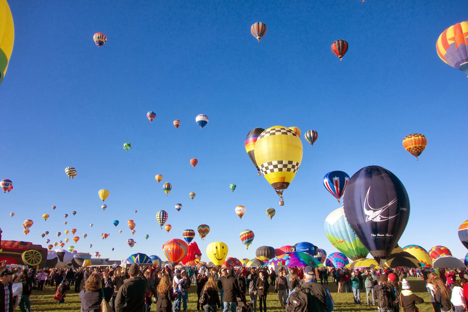 |
| Albuquerque Balloon Festival |
After a couple of hours I was pretty much tired with looking
at balloons, even tired of the chain saw carvers who were demonstrating their
skills (an odd combination), so I headed back to Santa Fe. It was well worth the early morning start and
I would highly recommend this event.
One morning is enough however – apparently it goes on morning and evening
for an entire week.
 |
| Santa Fe Architecture |
In Santa Fe I toured around the downtown area on the bike. It was nice enough though a bit touristy –
lots of expensive artsy shops and a lot of well healed tourists. I did go through the Georgia O’Keefe
Gallery. In small doses, I like her work
and this gallery was not too large to put me off. One thing I found out there was that in her
early days she worked in Canyon, Texas the town near the Palo Duro canyon I had
passed through the day before.
From Santa Fe I headed north west to Los Alamos. This was the headquarters of the Manhattan
Project in World War II. I had expected
there to be some remnants of that period, but not a lot remains. There was a statue of Oppenheimer and Groves
in the center of town and Oppenheimer’s old home was still present, though not
accessible in any way. Still Los Alamos
was a refreshing change from the tourist-clogged streets of Santa Fe.
From Los Alamos I drove on to Taos where I was to stay with
friends (Bart De P. who lives there and John G.who was visiting from Sacramento). Bart has a beautiful house in the foothills
of the Sangre De Cristo mountains near Arroyo Hondo. I stayed a couple of nights to assist on
Sunday with the construction of Bart’s new greenhouse – lots of fun.
 |
| Bart and the Greenhouse Project |
Monday – Taos to Flagstaff
Monday morning it was back on the road with a destination of
Flagstaff. The drive down to Albuquerque
was a repeat of Saturday’s ride and then I headed west on Interstate 40. Nothing too exciting today, I passed through
Gallup where I had lunch at the old El Rancho Hotel. This must have been a splendid place in its
day and apparently it was the stopping of place for many Hollywood
celebrities. They boast “the charm of
yesterday, the convenience of tomorrow” and the hotel is a National Historic
Site. The food could be better however.
 |
| The El Rancho in Gallup |
Tuesday – Flagstaff to Twentynine Palms
Tuesday morning was a pleasant morning in Flagstaff. It is a college town and it has a nice feel
to it. It is a railway town too and the
main line passes straight through town – lots of very long freight trains cutting
the town in two – like Sacramento, there are no railway bridges in town.
On the road I continued to travel west on I-40. As the previous day, there wasn’t much of
interest, or perhaps I was just getting tired and jaded. For some reason the handlebars on the bike
had worked loose and they were moving when I braked hard. In Kingman (another Route 66 railroad town on
I-40), I found a Napa parts store who just happened to have the right star
wrench to do the tightening job - lucky.
Next stop was a turn south towards Lake Havasu and the
infamous London Bridge. This is a
relatively new development on the banks of the Lake Havasu reservoir. The developer heard they were pulling down a
bridge in London so he arranged for the facing of the bridge to be shipped to
the USA. A weird idea but apparently it
worked – the development did take off and has been reasonably successful. Not my cup of tea however.
From Lake Havasu it was a late afternoon ride south down to
Parker (an interesting looking town) and then west to 29 Palms. A lovely ride over a nice roller coaster of
a road.
Wednesday – Twentynine Palms to Bridgeport
The skies looked a little ominous on Wednesday morning and
the forecast was for heavy winds and even rain and snow in the direction I was
going. With nowhere else to go, I set
off hoping that the weather report was wrong.
I passed through Joshua Tree (another National Park that was closed) and
headed over to Victorville and yes it was windy. I was leaning into the wind the whole
way.
 |
| A Joshua Tree |
Victorville is again on the old Route 66 and it was also a
railway town. I didn’t look that welcoming
somewhat industrial with a cement works or something on the edge of town and,
because of the wind, dust blowing everywhere.
I stopped for breakfast in Victorville at some nice little diner (Emma Jean's).
Just outside Victorville there is a relatively new looking airport,
a cargo airport, with all sorts of planes lined up. Not much traffic today though, just high
winds blowing dust around. I learned later this is the Southern California Logistics Airport and it is a repurposed old air force base now being used for freight.
Driving north I joined Highway 395 for the ride up the east
side of the Sierras – my favorite part of California in the shadow of the High
Sierras. The wind died down but the
clouds were looking ominous, and sure enough the rain started around Big
Pine. I suited up with the heated vest
and waterproof jacket and pants and pushed on.
The rain made things a bit unpleasant and by the time I got to Bishop I
was considering stopping there for the night.
I fueled up in Bishop and warmed up in a Starbucks. After deciding to call it a day and find a
hotel I came out of the Starbucks to find a hole in the clouds and the sun
shining through. I figured that was the
sign to keep going so I pushed on northwards.
The weather was fine only for a while and by the time I got
near Mammoth it was turning bad again and as I climbed the pass north of
Mammoth it started snowing. I crept over
the summit with ice on my fairing and helmet visor. I made another cautious ride over the pass
north of Mono Lake in the ice and snow before dropping into Bridgeport where I
did stop for the night. I stayed that
night with friends from Sacramento, Ken and Diane, who were staying in a cabin
west of Bridgeport.
Thursday – Bridgeport to Sacramento
 |
| The Bike with Snow in the morning |
The next day the weather was much better and after a
leisurely start to the day, I made the most pleasant ride back over Monitor Pass to
Markleville, the Hope Valley, over Carson Pass and down to Sacramento. This was to be my last long ride on the bike
and I was really enjoying it.
A couple of weeks later, I cleaned up the bike, repaired the
broken side panel, and put it up for sale on Craigslist. It sold within a couple of days.


