Just before 4th July weekend I decided to do some camping down at altitude as training for my upcoming attempt to run the TRT 55K race in a couple of weeks time. Since the race starts at 4,800 ft and rises 4.400 ft up to 9,200 ft, I thought it would be good to get some altitude acclimatization.
On the Thursday I did my long run before the race, 28 miles up in Tahoe. I left Sacramento just after 4 am to get up to the trailhead at a reasonable time. I think I was on the trail just before 7:00 am. I parked at Spooner Summit on Highway 50 and set off to run down to Spooner Lake and then up north towards Tunnel Creek.
.jpeg) |
| Where's the mother bear? |
I hadn't got more than a few hundred yards down the trail when I was startled by a scratching and scraping as some animal, a bear, scrambled up a tree just in front of me. It took me a while in my early morning dreary state to figure out what was happening - it think both the bear and I were equally startled. Nevertheless the bear was up the tree on the side of the path and I wasn't going to get any closer. I backed off and pondered what to do. Take a picture of course. Give it some space and hope that it would get out of my way which it eventually did. I proceeded with great caution making as much noise as I could for a while until I was well out of the way. I later realised that this was a young bear and there should have been a mother around somewhere to protect it. The mother would be the one to give me grief but I didn't see her.
.jpeg) |
| Spooner Lake |
From then on things were a lot less dramatic. Spooner Lake was looking lovely and the Marlette Lake Trail was a nice gentle uphill for a few miles then a nice descent to Marlette Lake itself. I was then on the TRT course and there was that nasty little uphill in the heat of the day up Marlette Lake Road to Marlette Peak Campground. From there I continued on the TRT around Herlan Peak over to Tunnel Creek. Along the way I met Mary Ann (and Veronica, Ling Ru, Julie and Sandy) who were running in the other direction. Down at Tunnel Creek I turned down the Red House Flume Trail towards Red House Dam. That is a long hot and dry stretch. For much of it there was a water pipe running next to the trail. I was surprised to find that it was carrying water and as a result was quite cool. It was very nice to stretch out on it in the hot afternoon sun.
.jpeg) |
| Marlette Lake and Tahoe in the background |
After the dam it was up on Franktown Road to join Marlette Lake Road up to Marlette Peak Campground once more. This was the most difficult section for me - uphill, exposed and quite hot. At the campground I went to the pump and filled up my water and set off back on the Tahoe Rim Trail back towards Snow Valley Peak and Spooner Summit. From Snow Valley Peak it was a nice gentle downhill trail to Spooner. Needless to say I was quite tired when I got back to the car. What was supposed to be a 26 mile run was actually a 28 mile run. If I were to believe my Apple watch it would be 31 miles but I that could not be the case. A10% variance between the Apple watch and my Garmin is a lot more than I would expect.
After the run, I drove down into Carson City where I had a room. A shower and a bite to eat at Red's and I was done for the night. The next day I walked around Carson City a little before heading south on 395 towards Bishop. Mono Lake was looking quite splendid but quite full. There is not so much exposed tufa these days so in some ways it is not as spectacular as it once was. I stopped for a break in Lee Vining at the very busy Chevron Station at the entry to Tioga Pass. Gas was a whopping $7.94 for premium.
 |
| Lee Vining Gas - high even for California |
In Bishop, Schatt's was its usual crowded and busy self - they have become somewhat of an institution and a required stop in Bishop. It was too busy for me though so I compromised and got groceries at Vons.
From Bishop I headed up Silver Canyon Road into the White Mountain and Bristlecone Pines area. The road heads up Silver Canyon making several water crossings in the lower sections. I came across a group of Desert Big Horn Sheep along the way. They didn't seem at all perturbed by my presence and barely seemed interested in getting out of my way.
 |
| Desert Big Horn Sheep |
 |
| Silver Canyon |
The road heads up hill on an impressive switchback trail rising some 5,000 feet in just a few miles. At the top there are wonderful views down the canyon to Bishop and the High Sierras on the other side of the valley.
At the top there was a staging area for power line installation equipment. They were replacing the power line from Nevada into California (or the other way) and there were trucks and equipment at the top of the pass. I talked with one of the workers for a while. They normally commute by helicopter and the helicopter moves all the supplies, including the poles out to the desired locations.
 |
 |
| The view from White Mountain Road |
From the top of the pass the road then joins the White Mountain Road which runs out to the north as far as the trailhead and beyond, past the gate, to the UC High Altitude Research Station, to the top of White Mountain. I drove as far as the trailhead gate where several people were camping. I was looking for a high altitude camping location that wasn't too exposed. The trailhead was high but it was a bit windswept. I turned back and took a side trail to the east and found a nice spot at the top of the road down into Cottonwood Canyon.
 |
| The campsite above Cottonwood Canyon |
It was a little more sheltered than other locations on the White Mountain Road and yet it was still relatively high - 11,200ft. I was looking for high altitude because I thought it might help me with acclimatization for my upcoming run - in actual fact I don't think it made any difference. I pitched the tent and cooked a little dinner whilst enjoying the view towards White Mountain and then down Cottonwood Canyon. As the sun set I learned once again that things get pretty cold when the sun goes down at those higher altitudes. I was in the tent and in the sleeping bag before darkness fell.
My camp site was indeed a beautiful location with great views and over to the east and the endless ranges of the Great Basin. I pottered around camp in a very leisurely morning before deciding to explore further down Cottonwood Canyon. It was as steep and rough road down but at the bottom it was quite pleasant. There was an old cabin at the bottom - who built it, when was it built, how on earth did they survive in such a remote and difficult location I do not know. Unfortunately the road reached a dead end after a while so I returned back up the hill.
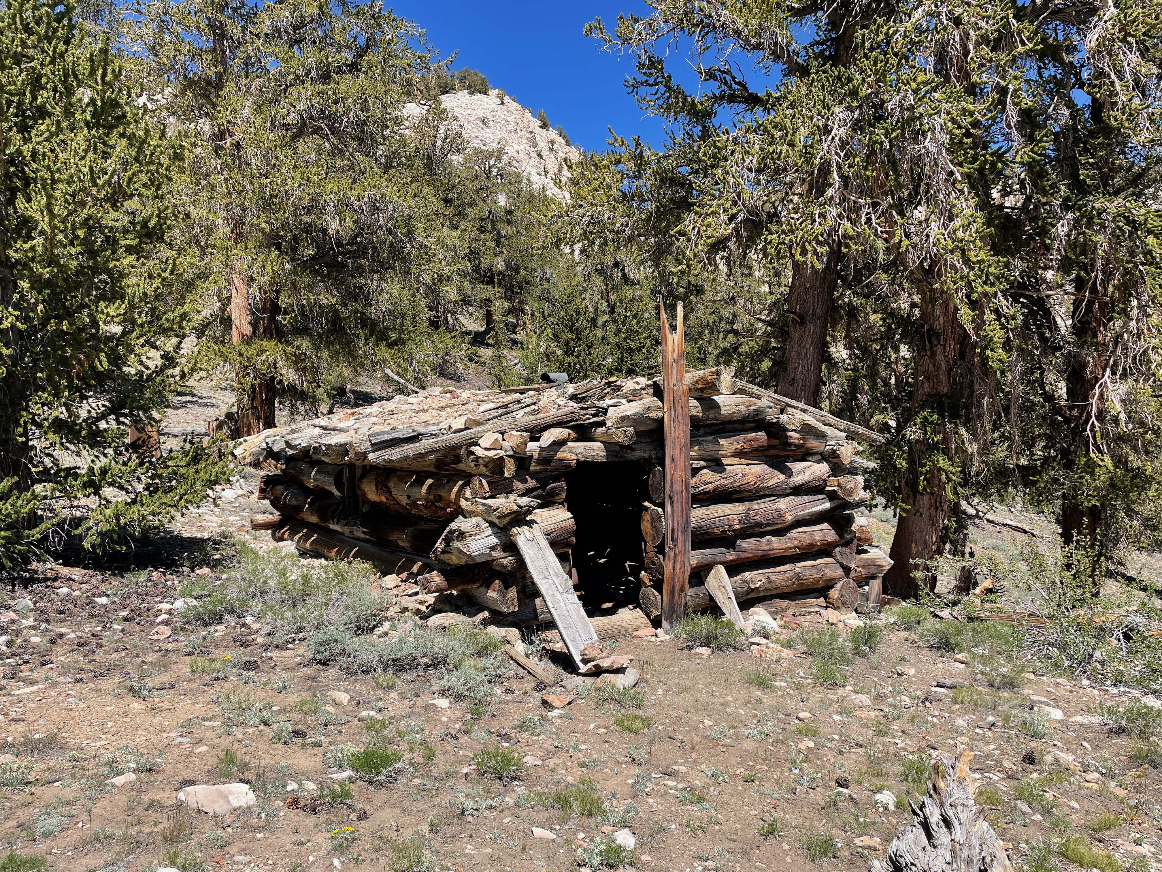 |
| Cabin in Cottonwood Canyon |
On the way out of the canyon, I heard a pop and low and behold I got a flat tire. A chunk of rubber was ripped away from the side of the tire. There was no possibility of fixing that. That was a bit of a problem as I was a long way from anywhere and stuck on the side of a hill. I limped to a relatively flat spot close to my camp and set about changing the tire. Of course I had never changed a tire on the 4Runner before; never operated my Hi Lift Jack; never lowered the tire from beneath the 4Runner; never used the locking tire nut wrench; never realized the spare is not full size. So there were lots of discoveries and difficulties along the way but I got it done and, in the end, was quite proud of my efforts.
But then I had a problem - a less than capable off road tire in an off road environment. I decided to limp back up to the road and drive into Bishop to see what I could do about a new tire. It was Saturday afternoon before a 4th July weekend - what were my chances? It was easily a 90 minute drive and as I got into Bishop I had 20 minutes before the only tire store that was open closed for the holidays. Perez's Quality Tires were able to fix me up with a reasonable off road capable tire - $300 installed. I couldn't believe my luck. Before the end of the afternoon I was back up Silver Canyon Road to my campsite.
 |
| White Mountain |
The next day, Sunday, I decided to go up White Mountain. I had a leisurely breakfast in camp and then set off for the trailhead. I had hiked up this trail 2 or 3 times before so I was quite familiar with it. The air is thin but I was feeling good and traveling light so I was able to make good time. The mountain is impressive and when you get around the eastern side it is a bit of a slog up the rocky switchbacks to the peak. Most of the snow was gone but there was just one section where I had to cross a snow bank. I finally made it to the top where there is a stone cabin - 3 hr 20 mins, 7.5 miles and 3,000 ft of gain up to 14,252ft. The youngsters at the summit were impressed by my senior years.

 |
| Summit White Mountain |
The way down was, of course, easier but only a little quicker (3 hr). I was tired after all the exertion and my camp was most welcoming. I slept well.
 |
| Bristlecone Pine |
Monday morning was the 4th of July. Not much of a celebration for me but I did enjoy a nice leisurely morning basking in the sun. Later on I set off to explore the area. I visited the Patriarch Grove of Bristlecone Pines. This is the grove containing the largest (in trunk circumference) Bristlecone (but not the oldest). From there I went down Wyman Canyon on a nice dirt road that winds down the hill all the way to Highway 168 that runs from Big Pine east to the Nevada border.
Since I was in the need for ice and beer I drove into Big Pine to replenish supplies and drove back up the hill to camp.
Tuesday was another leisurely day. I enjoyed sitting in camp reading my book (Conquest of the Useless by Werner Herzog) and drinking coffee. I did set off to do more exploring down an alternate route into Cottonwood Canyon. A nice trail down the hill and an absolutely gorgeous camp spot at the bottom by a creek. A place to return to. Again there was a cabin down there where some intrepid and hardy soul had tried to make a living in this harsh and remote land. The road ends just after the creek so I retraced my path out of the canyon back to my camp.
 |
| Bottom of Cottonwood Canyon |
Tuesday night was exceptionally windy. I was forced in the tent early and the flapping of the tent made for interrupted sleep the whole night. In the morning I broke camp and packed up for the return to civilization.
Once more down Silver Canyon Road where I was briefly held up by the helicopter moving building materials for the power line installation. They wouldn't let anyone pass until the helicopter had moved well away. It was then on to Bishop and the long drive home up 395.
 |
| Helicopter Delivery |
I can't remember staying in one place to camp for so long but I really enjoyed it. I am sure I will be back down to that area again. It is so dramatic, so beautiful, so remote.