|
| My Favorite Warsaw Building, Stalin's Birthday Cake |
In Warsaw I had to pick up my train ticket to Kiev which I had already booked and paid for. For some reason the ticket could not be picked up at the station but it was delivered in my name to the Poste Restante at the local Post Office. I wasn’t aware that they did Poste Restante anymore.
 |
| The Powazki Cemetery, Warsaw |
With my ticket in hand, I had a few hours to kill until my 5:00 pm train and since I had seen most of the bigger sites in Warsaw I decided to visit the Powazki Cemetery, a fine old cemetery with wonderful old monuments and gravestones. Many notable Polish people were buried there, none of whom I recognized other than perhaps one of Frederick Chopin’s relatives. It was a great place to wander around looking at all the beautiful and quite extravagant gravestones.
I took the tram back into the city center and walked over to the old town. After it was flattened in WWII they have done a remarkable job of rebuilding the city and it is now quite beautiful. A late lunch of pierogis, which didn’t impress me as much this time as last, and then it was off to the station for my train.
 |
| The night train to Kiev |
I had a sleeper compartment all to myself and it was quite comfortable and clean. We pulled out of the Warsaw Central exactly on time and we crossed the Vistula River heading east towards the Ukraine border. This late in the year it gets dark quite early so there wasn’t much to see out of the window. As we left Poland there was a passport check then in the early hours of the morning we rolled into a large covered shed to change the wheels on the railway carriages. Each carriage was lifted up by large hydraulic rams that slide under the carriage body. The 4’ 8.5” European gauge wheels were rolled out and a set of 5’ Soviet gauge wheels rolled in. The process is quite gentle and I am sure most people slept through the entire process. I of course was intrigued by the whole process and I watched the whole process.
 |
| New Carriage Wheels for the Ukraine |
With new wheels installed we rode on towards Kiev though pleasant countryside and the occasional town. We pulled into the main station in Kiev right on time. There was then a customs check, complete with stern Soviet-style Guards and contraband sniffing dogs, before we were allowed to get off the train.
 |
| St Voldomar's Cathedral |
It took me a while to get my bearings but I eventually figured out which way it was to the center of the city and my hotel and I set off to walk. On the way I passed a spectacular church with multiple beautiful gold and blue domes. This was St Volodomir’s Cathedral. The inside was no less spectacular than the outside with beautifully ornamented domes, altar and icons. In Orthodox churches there are no pews and everyone stands - that has to be tough on the old folk. There were lots of people coming and going, all seemed to be buying candles and lighting them in front of their favorite saints, saying prayers and then crossing themselves.
 |
| The Hotel Ukraine |
I walked on towards what is the main street in Kiev, Kreshchatyk Street. It is a wide street with some very impressive buildings that runs down to the main square, Maidan Nezalezhnosti. Apparently when the Germans left the city in WWII they mined and booby trapped all the buildings on the street.
 |
| The Founders of Kiev Monument |
My hotel, the Hotel Ukraine, sits up the hillside from the main square, Maidan Nezalezhnosti and it is a massive Soviet era edifice. It is quite ugly but then that’s what makes it all the more appealing to me. It was built to honor Stalin but he unfortunately died before completion and then even Kruschev found it to be quite ugly and so he never approved the completion of the final upper floors.
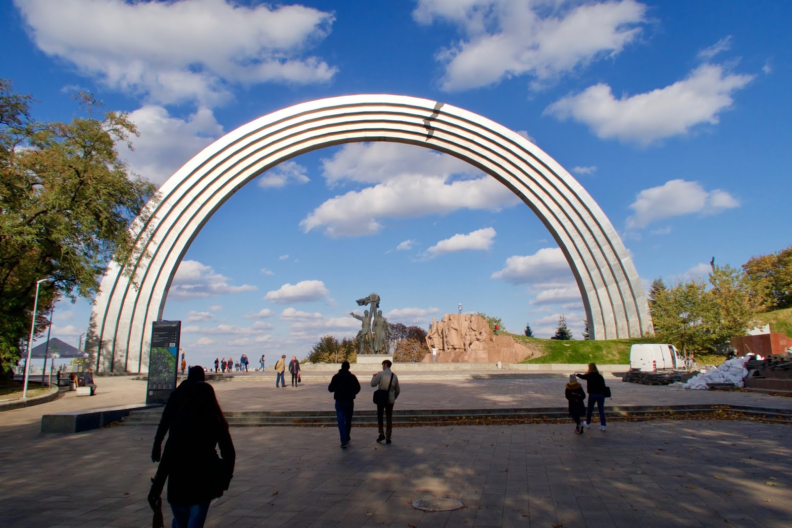
After checking in and having a bit of lunch I wandered over to the Maidan square and found a walking tour that was just about to start. It provided a nice introduction and orientation to the city. From the square and the Founders of Kiev monument (three brothers and one was called Keith) we walked up to the Friendship of Nations Arch. This soviet era memorial commemorates the friendship between the Ukraine and Russia. That friendship is not so good these days but the statue there shows a Russian and a Ukrainian standing together.
 |
| The Friendship of Nations Arch |
 |
| Friendship of Nations Statue |
Just past the monument there is a nice view down to the Dnieper River and the old part of town. We walked on through Mariyinsky Park, past the statue of the WWII lovers, over the Devil’s Bridge, past the soccer field where Ukrainian prisoners played the Germans in WWII and paid the ultimate price (their lives) for beating them (three times).
At the end of the park is the Mariyinsky Palace, designed by Rastrelli and built for the Tsar and still looking rather splendid. It is now the official residence of the President of Ukraine.
 |
| The House of Chimeras |
 |
| Rooftop of the House of Chimeras |
Nearby was a most wonderful large home, the very exotic House of Chimeras. This is an Art Nouveau house built in 1902 by Wladyslaw Horodecki. It is the most ornate building you could imagine being adorned by all sorts of strange beasts and hunting scenes. What a gem.
 |
| St Sophia's Cathedral |
A couple of other minor buildings and we were done with our walk. I then set off on my own up the hill on the other side of Maidan Square to St Sophia’s Cathedral. This is a fine complex of domed churches, not as spectacular as some of the others in that it has less gold and is green instead of the more resplendent blue.
 |
| Bohdan Khmelnytsky Statue |
In the square outside St Sophia’s is the Bohdan Khmelnytsky statue - a monument to a cossack leader who defeated the Poles back in the 17th Century and at the other end of the square is the much more beautiful St Michael’s Monastery. St Michael’s has lots of wonderful gold and blue domes. As beautiful as it is, alas it is only a modern copy being built in 2001 after the original was torn down in 1937. I imagine it is now much more splendid than the original ever was.
 |
| St Michael's Monastery |
In the evening I had to figure out how to get to the pick up point for my Chernobyl Tour the next morning. The instructions were a bit sketchy - just meet at 7:45 on a street by the railway station where there should be a minibus waiting. So I decide to go over there and check things out ahead of time and, of course, it gives me a chance to check out the subway system in Kiev. The subway here is the deepest in the world and it is quite impressive - exceedingly long escalators and quite ornate stations. You buy a plastic token for 8 hryvyna (25c) that gets you in the station and then it is a long descent on escalators to the platforms. The system is very busy and the trains are very frequent - almost following one after the other down the track. A most efficient and affordable means of transportation. I traveled on the subway many times while I was in Kiev and never had to wait more than a couple of minutes. I find my meeting point for the next morning’s trip and then return to my hotel. A cheap but good meal of borscht and salad in a nearby restaurant before retiring for the night.
Next morning (Wednesday) was an early rise to catch the subway across to the railway station and meet my Chernobyl Tour van. When I was looking into visiting Ukraine I didn’t expect that Chernobyl would be on the list of places to visit but the site of the world’s worst nuclear accident has been opened up to any intrepid travelers that want to pay a visit. I didn’t expect there to be many people on the tour but were a minibus of 15 people and there were 3 other buses waiting in the same spot.
Our guide, Anna, was quite competent and knowledgeable and spoke perfect English. We set off for the 1hr 45 minute drive to Chernobyl. At the entry to the Exclusion Zone, a 30km ring around the reactor that has controlled access we had our paperwork processed and were given dosimeters to hang around our necks and a geiger counter to play around while we toured around the various sites.
 |
| Abandoned House, Zalissya |
Our first stop was Zalissya, a village where the houses were abandoned but were left standing. Other villages closer to the reactor site were bulldozed and the debris buried. We spent 30 minutes wandering around this village where roads and gardens were now overgrown and houses being mostly of wood construction were slowly falling down. The residents of the village were given very little time to get ready for what was supposed to be a temporary evacuation so most things were left behind. Furniture, beds, clothing, books, papers were just lying around. The most memorable sight was a clinic with an examination table with foot stirrups rusting away in a debris strewn room.
 |
| Clinic in Zalissya |
 |
| Children's Home |
The next stop was at an old nursery or children’s home. This was quite moving - rows of beds in the wards and lots old toys lying around. Sad to think what this place might have once been and how quickly it was abandoned to the elements and how quickly nature took over once more.
 |
| Geiger Counter at Radiation Hot Spot |
 |
| Pripyat Town Center |
Just outside the town of Pripyat we stopped to examine an area of highly radioactive ground. Everyone busied themselves with their geiger counters looking for the highest reading they could find. I got 28 microsieverts per hour which really is not too much at all considering what went on there.
Pripyat was the largest town affected by the disaster. When the reactors were first built the nearest town was Chernobyl and so the site took its name from that town, but in 1970 a larger modern town was built to house all the nuclear workers. That was Pripyat. It was a flagship town for the Soviets with all the modern facilities - a swimming pool, a basketball court, an amusement park, restaurants, a hotel and even a supermarket. The residents left with only two hours notice and most never returned (some came back to retrieve items valuable or sentimental to them). In recent years it has gained notoriety for being the post-apocalyptic backdrop of a popular video game that uses actual footage of present day Pripyat.
 |
| Swimming Pool, Pripyat |
Our first stop in Pripyat was at the swimming pool. Normally you are not allowed inside the buildings in Pripyat but our guide knew that at that time of day there were no police at the site so we could sneak in to take a look around. It must have once been a first rate facility but now it is just a decaying shell around a crumbling empty pool.
 |
| Amusement Park in Pripyat |
We then took a walk around the town itself - the soccer stadium, the amusement park, the supermarket, the hotel, the school, a cafe, municipal offices, a theater, etc. Trees and bushes were growing in all the roads and the buildings were slowly disintegrating. It was all quite remarkable and all quite moving. The rusting bumper cars and the carousel; the masses of gas masks on the floor of the school room; the coffee machine at the cafe; the abandoned supermarket trolleys in one of the first supermarkets in the USSR. All signs of what the world might look like if we screw things up any more. How quickly nature can once again gain control.
 |
| Gas Masks and other debris |
 |
| Pripyat Graffiti |
People for some time have been entering the exclusion zone illegally. They camp out or squat in the buildings until discovered or until they feel they have had enough radiation. Some have even adorned walls with murals and graffiti.
 |
| The New Sarcophagus Covering the Reactor No 4 Site |
After leaving Pripyat we drove past the Red Forest area. This was a contaminated area where all the trees turned red after the incident. There are none of the original trees there now. They have all been uprooted and buried and a younger forest is taking over. We then approached the reactor area itself. There is a memorial to the incident adjacent to Reactor No 4, the one that had the accident. The reactor is now covered by the new sarcophagus cover. Financed by the EU it is the largest moveable construction project in the world. It was recently slid into place over the core of the reactor and it will hopefully give protection for another 100 years. By that time we may have figured out a better way of dealing with the problem.
 |
| Radiation Check before Lunch |
Our trip included lunch at the works canteen adjacent to the reactor complex. Before entering the canteen we had to pass through a radiation scanner. I don’t know whether this was just to make us feel safer or whether they did occasionally find something alarming and in need of decontamination. Thankfully our party were all clean. It wasn’t the best meal of goulash and borscht but it served the purpose.
 |
| The Duga |
After lunch we left the reactor site and drove to look at something called the Duga. This is a giant radio antenna that was built in the 70’s to act as a detection site for incoming missiles from the west. It is an impressive structure but it never really worked that well though it did create interference on global shortwave radio frequencies. It produced a clicking sound that became known by radio enthusiasts as the Russian Woodpecker. We walked around the immense structure and through abandoned military buildings in the area. A most interesting site.
 |
| Memorial in Chernobyl |
At the end of the day we visited the town of Chernobyl. Here there are still people living and working (though I think only for 30 days at a time before having to leave for a while). There is a monument in town to the workers who performed some heroic and life endangering tasks to limit the extent of the disaster. Whether they were the power plant engineers, the police, firemen or soldiers brought in to work on the containment, the miners who dug tunnels under the plant, or medical professionals who treated the sick, they were indeed heroes that worked in conditions that many of them knew would drastically shorten their lives.
 |
| Final Radiation Check for the Van |
At the end of our visit there was another radiation check to make sure we hadn’t become contaminated. We all gave our dosimeters and geiger counters back. Mine showed I had been exposed to 3 microsieverts of radiation. That is less than a tooth X-ray or less than a flight across the USA.
It was an uneventful ride back to Kiev where we were deposited at the railway station. All in all a remarkable day trip. Quite thought provoking. The world really dodged a bullet with that disaster. There were so many ways it could have been so much worse.
 |
| Old Kiev and the Dniper River |
The next morning, Thursday, I set off to do my own walking tour of the city. I retraced some of the path I had taken on Tuesday by visiting the House of Chimeras (always worth another look), the Mariyinsky Palace, the Devil’s Bridge, the Friendship of Nations Monument. Then I crossed over the new bridge/viewing platform to the other hillside and the statue of St Voldomar that sits on a hill overlooking the old town and the Dniper River.
My path then skirted around the hill to the wonderful St Michael’s Monastery.
 |
| St Michael's Monastery |
 |
| Interior of St Michael's Monastery |
Then heading north down the hill on Andriyivsky Street I passed another spectacular church, the turquoise green St Andrew’s Church.
 |
| St Andrew's Church |
At the bottom of the hill is the old part of town, the Podil area. I wandered rather aimlessly around this part of town trying to get back to the other side of town without retracing my steps, but alas after a lot of walking along dead ends, I had to give up and go back up Andriyivsky Street.
 |
| Wall Art Kiev |
There are some wonderful murals in Kiev and I enjoyed discovering a few of them as I walked around. They are true works of art and it has become one of my favorite things to do in a new city. Every European city these days seems to have them.
 |
| Wall Art Kiev |
Along with my mural wanderings I stumbled across an old entrance to the city in Medieval times called the Golden Gate or as we say in the Ukraine, Zdoti Vorota. It was unusual but not epic and it also turned out to be a modern day 1982 copy of the original.
Further on I encountered again the very splendid St Voldomirs Cathedral, something I saw on the first day. Further down the street is Schvenchenka Park with a statue of Mr Schvenchenka himself just outside the main Kiev University building. Schvenchenka was or is the most famous Ukrainian poet. Alas I had never heard of him or his work.
 |
| Schevenka Statue and Park |
I then pain a visit to the Pinchuk Gallery. An art gallery created by Viktor Pinchuk , one of the modern day Ukrainian oligarchs. It was hosting a rather sinister and perverse photo exhibition of a Soviet photographer who had some not too pleasant photos of Ukrainian/Soviet people. I can’t say I enjoyed it and I don’t even remember the name of the photographer. It did however provide me some respite from walking the streets of Kiev.
 |
| The Deepest Subway System in the World |
After a late lunch I set off to take a look at one more group of golden domed churches in the Lavra area. I took the subway from my hotel to the Arselina station which has the record for being the deepest subway station in Kiev and the world. It takes a full 4.5 minutes to traverse the escalators from top to bottom.
 |
| Upper Lavra |
 |
| Upper Lavra |
I walked around the churches in the Upper Lavra section and I peered over the walls to look at the equally spectacular Lower Lavra complex. Kiev has a lot of spectacular churches and cathedrals. I can’t say which is the best but it certainly makes for a beautiful city.
 |
| The Lower Lavra Complex |
 |
| The Nation's Mother statue |
From the walls of Upper Lavra you can also see the Rodina Mat statue otherwise known as the Nation’s Mother). An impressive huge steel statue of the Nation’s Mother holding a sword and a shield. There were similar statues in Tbilisi and Budapest. It must be a Soviet thing.
My phone told me I had walked 18.5 miles for that day and I was well and truly tired. I took the subway back to the hotel, had a quick dinner and collapsed into bed.
Friday morning was my last day in Kiev. I had a 12:00pm flight from the Borispol Airport so there wasn’t too much time left to sightsee. I went exploring for more murals in the area just north of the Maidan square and then caught the subway out to the station. From there I caught the modern airport train for the 30 km ride to the airport. At the airport there were three terminals C, D, F (why not A,B,C?). They were spread out requiring a shuttle bus between the terminals. Myself and just about everyone on the train were going to F, the budget airline terminal. We boarded the bus and though the bus was overloaded with people, it did not move -- not for 20 minutes. Waiting for 20 mins on an airoport shuttle bus is perhaps not what many people dialed into their travel plans that day. Fortunately I was in plenty of time.
An uneventful flight back to Stansted and I was back in the UK. All in all a most interesting trip. I highly recommend Kiev and I highly recommend Chernobyl if you have a liking for that sort of thing.
There are many more photos of Kiev here and of Chernobyl here.