In mid October I escaped for a few days down to Southern Utah. There were a couple of off road trips and hikes that I wanted to do and this was a perfect time to do it - nice warm weather without it being too hot and yet still a reasonable amount of daylight.
 |
| Onions as far as you could see |
I drove over to Nevada and took the route through Yerrington, Hawthorne to Tonopah. Just outside Yerington, they were harvesting onions. It was quite remarkable to see the productivity of the crop. An entire field stacked with literally hundreds of sacks of onions. How productive the soil can be.
 |
| Mina Motel |
 |
| The Boat Bar in Mina |
In the remote little town of Mina there is a nice old motel sign advertising $21.95 per night for a room. That must have been some time ago - though judging by the state of the hotel maybe not. The town also has a boat that has been converted into a bar. Not sure why a big boat ended up there but at least it is being put to good use.
 |
| The Mizpah Hotel, Tonopah |
I stayed in Tonopah at the Mizpah Hotel. This impressive old hotel is the tallest building in town, and was once the tallest building in Nevada. The hotel is the stuff of legends - Wyatt Earp supposedly kept the bar there, Howard Hughes married his second wife, Jean Peters there, and Jack Dempsey was for a while the bouncer. None of those legends stand up to much scrutiny and are all debunked but they live on. The hotel is also supposedly haunted. A woman was beaten to death on the 5th floor by a jealous husband or boyfriend and apparently she has been seen walking the corridors at night. I stayed on the 5th floor and didn't see or feel a thing.
 |
| The Extraterrestrial Highway |
From Tonopah I drove east and eventually joined Highway 375, the so called Extraterrestrial Highway. This highway runs along the north edge of Nellis Airforce Base which is where a lot of secret military stuff is carried out. It has become associated with all sorts of conspiratorial theories about aliens and government cover ups of the same. Nevada cashed in on this by naming the highway the Extraterrestrial Highway.
 |
| Alien Memorabilia in Hiko |
In the small town, extremely small town, of Hiko there is an establishment selling all sorts of alien related souvenirs - fridge magnets, mugs, T shirts, books, etc. There's a big statue of a supposed alien outside the building.
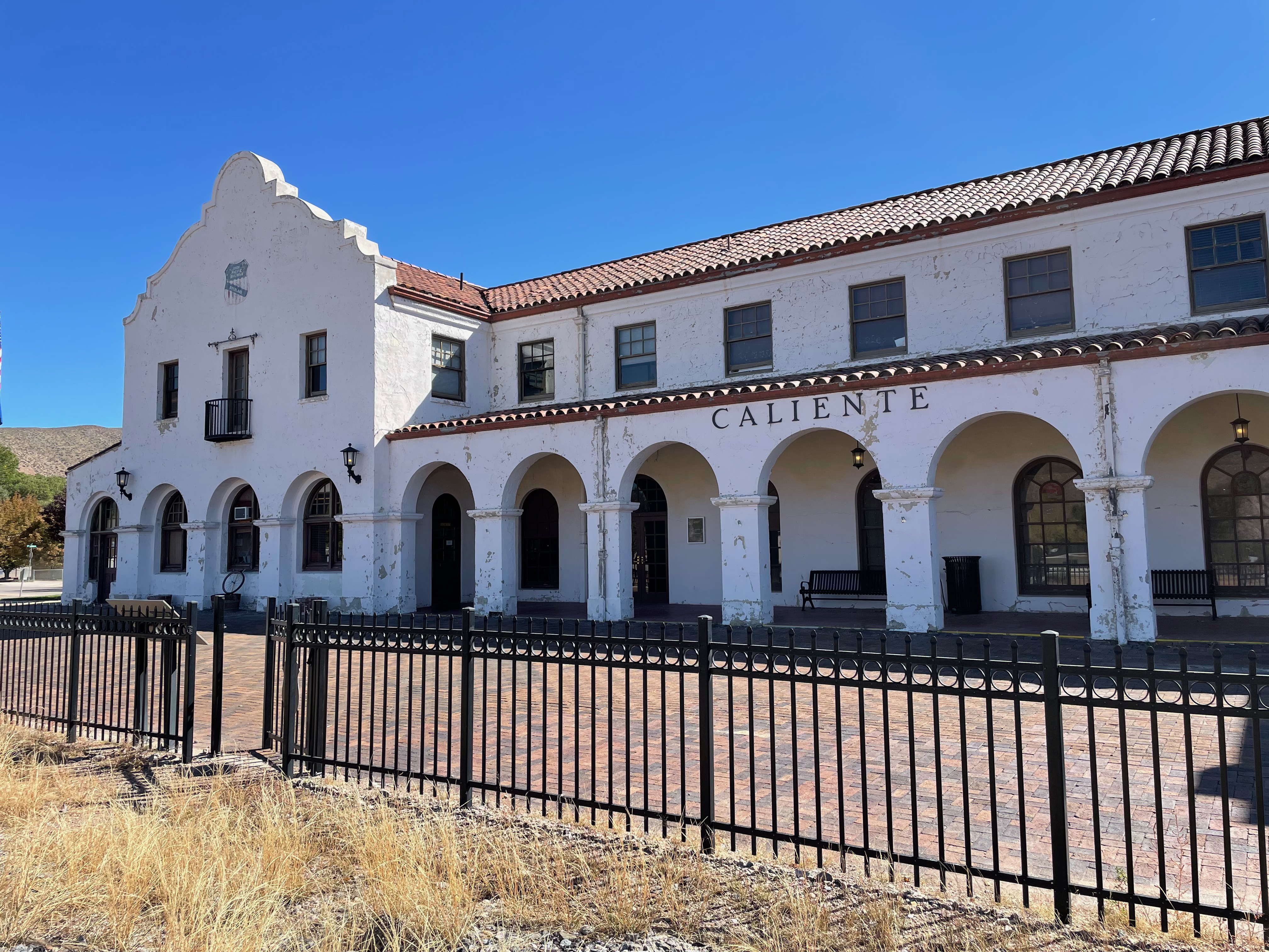 |
| Caliente Union Pacific Station |
I stopped for lunch in Caliente. A railway town in the past and while the railway still passes through there, that is all it does - just pass through. The station is now closed and there are no sidings for what once must have been a busy railyard. I did like the look of the old Union Pacific station however. They built nice stations in those days.
Late in the afternoon I arrived in Kanab and got a room at one of the many hotels there. Kanab is pretty much a tourist town these days. It promotes its links to the movie industry and calls itself Little Hollywood. So many Westerns were shot in the nearby area and there are commemorative plaques to all the actors all down the main street. It also is doing well from the boom in adventure travel with OHV rentals and tours of the area.
 |
| Smoky Mountain Road out of Big Water |
The next morning I set off to explore some trails in the area. Highway 89 runs east from Kanab and then there are several trails heading north from the highway that pass through the Escalante National Monument. I had done the Cottonwood Trail on my last visit to the area so I went a little further east to Big Water and turned north on Smoky Mountain Road. This road is so called because of the many coal beds in the area, some of which are supposed to be burning (I didn't see any indication of that however).
 |
| Smoky Mountain Road |
 |
| On the way up the Kelly Grade on Smoky Mountain Road |
After crossing a wash this road climbs up and around some spectacular mountains. The scenery in Southern Utah is just spectacular - it is one amazing sight after another. The road switchbacks up the hill to the top of the Kelly Grade and the overlook at the top.
 |
| View from the top of the Kelly Grade |
From there the road is relatively flat on top of the plateau. The road is in good shape and I could maintain a good speed. It was quite a distance to Escalante and I finally reached the town and the tarmac just after 6:00 pm. I stopped at a restaurant in Escalante for dinner and debated what to do next. I decided to make a run out on the Hole in the Rock trail.
It is almost 60 miles of dirt road to the Hole in the Rock and my memory from an earlier attempt, over 10 years ago, was that the road was quite challenging. It was after dark when I left Escalante with the intention of driving to the start of the trail and then sleeping there in the 4Runner. When I got to the trail I found it to be much improved and in quite good condition. A dirt road that could easily sustain 40 mph. I had recently had a light bar added to my front bumper so I was interested in trying it out so I decided to continue driving for a while. The new lights were excellent and they lit up the trail like it was daylight.
 |
| Camp spot for the night, Hole in the Rock Trail |
I ended up driving 50 miles in the dark almost all the way to the Hole in the Rock. I stopped 5 or 6 miles before the end of the trail and settled down in the back of the 4Runner ()on my new sleeping platform. I was well pleased with my new drawer/bed system in the back of the truck and I had an excellent night's sleep.
 |
| The Hole in the Rock |
The next morning after breakfast I drove the remaining miles to the end of the trail and the Hole in the Rock. The Hole in the Rock is a slot or gully or ravine down which Mormon Settlers back in 1880 lowered their wagons and livestock down the 1 1/4 mile trail to the Colorado River in order to cross to the other side. It is a narrow and steep trail and it is just inconceivable to me how wagons and horses and livestock could be lowered down such a difficult trail.
 |
| Not an easy path |
 |
| The view down to the Colorado River |
 |
| Bottom of the Hole in the Rock |
I scrambled all the way down to the Colorado. It is a steep and tortuous rocky trail that is a slow climb over one boulder after another all the way down to the river. At the water level the beach was covered in tiny shells. It looks like the water level is down this year and these molluscs were left high and dry.
Climbing back up the trail was also quite an effort. Some parts required some rock climbing skills - it certainly was not a trivial route even without a wagon and horses.
 |
| Dance Hall Rock |
I drove back out the same way as I had driven in the previous night. This time appreciating the scenery in the daylight. There were a couple of things that were worth examining. The Dance Hall Rock is a natural rock amphitheater that was used for music and dance by the settlers. I bet the acoustics were good and the setting is just beautiful.
 |
| Chimney Rock |
The next stop was Chimney Rock. In the middle of a relatively featureless area stands one isolated tall spire of rock. Quite remarkable.
I also read about an awful accident in the 1960s at a place on the trail called Carcasse Wash - a truck full of boy scouts on their way to the Hole in the Rock stalled on a hill and suffered a brake failure. The truck rolled over and down hill and 13 scouts and adults were killed in the accident.
 |
| The Devil's Garden |
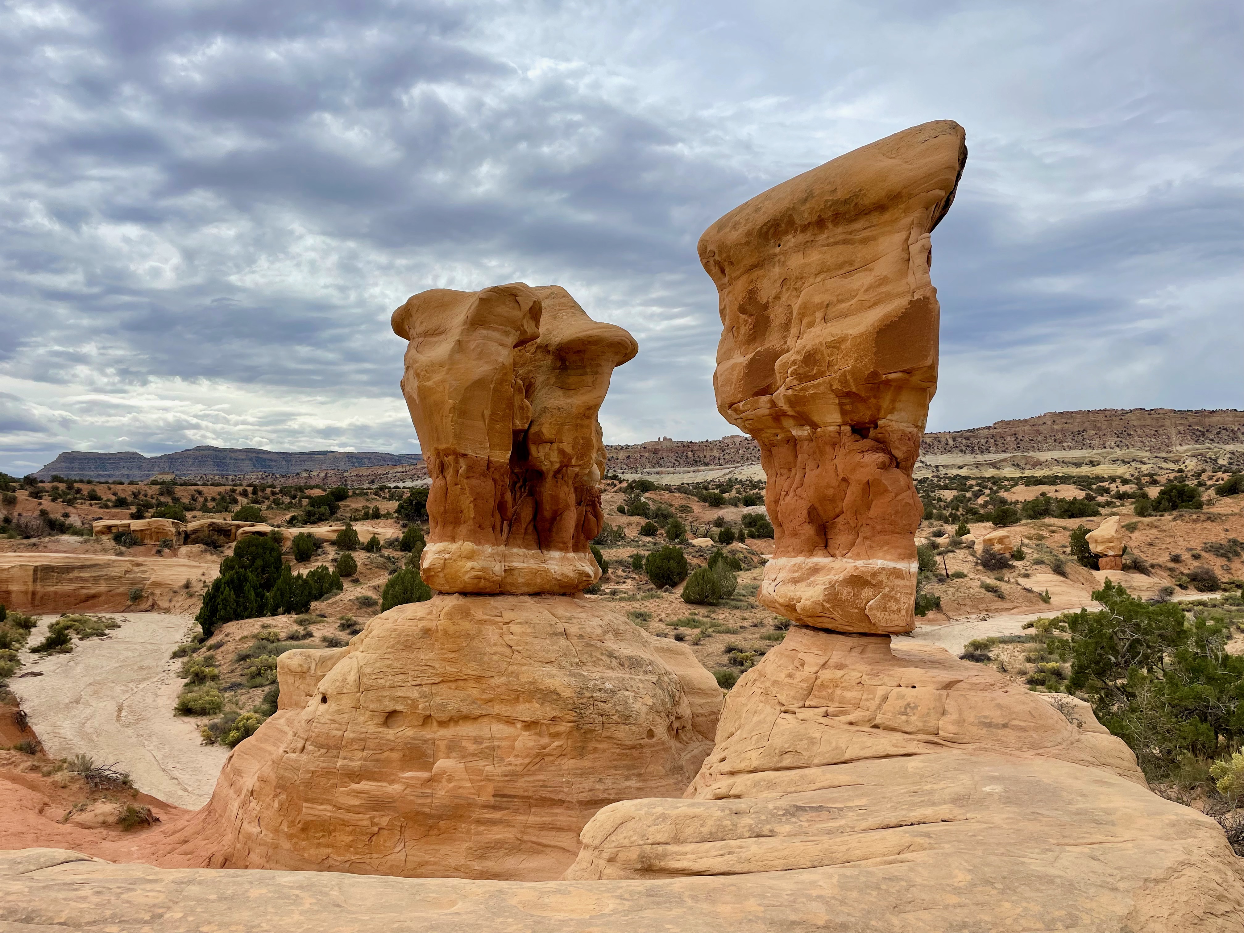 |
| The Devil's Garden |
Finally just before getting back to the main road in Escalante there is an area called the Devil's Garden. It is a little pocket of land just off the trail that is full of very weird and wonderful rock formations - beautiful eroded sandstone pillars balancing on top of sandstone bases. A delightful little area that can be walked around in an hour with simply amazing rock formations.
The Hole in the Rock trail exits onto the main road just east of Escalante. In the late afternoon, I drove back towards Kanab through all the villes - Henrieville, Cannonville, Orderville, and then on to Mt Carmel Junction and down to Kanab once more. I had a meal and then decided to go out to the Wire Pass Trailhead where I would sleep for the night.
It was dark when I turned off the tarmac onto House Rock Road. Now that I was comfortable with driving off road in the dark I continued for the 10 miles or so to Wire Pass Trailhead where I set up to sleep in the 4Runner.
 |
| The hike into The Wave |
 |
| The hike into The Wave |
Another comfortable night's sleep before awakening at dawn to prepare for the hike into "The Wave". I thought there would be a lot of other folks wanting an early start on the trail but no. Just a couple of other parties were early starters and that was it. The Wave is a rock formation in the North Coyote Buttes area. It has become quite popular, especially since one of the versions of the Windows OS had a picture of it as a screensaver. The trail is maybe 4 miles in and while some of it is well marked in other places it just traverses expanses of rock and sand with no definitive trail. Fortunately the phone with the GaiaGPS app kept me on the right path.
 |
| The Wave |
Arriving at the "Wave" was quite a wonderful experience. There is a little scramble up the side of a canyon and you pop into this area of multi-colored sandstone layers that have been contorted since deposition and then polished by flows of water. Simply one of the most amazing formations that I have ever seen.
.jpeg) |
| The Wave |
.jpeg) |
| The Wave |
Once at the Wave there is a loop trail around the area that takes in some other nice features - a less spectacular Second Wave, an Arch, a beautiful sandstone wall, interesting shaped pillars of rock,
.jpeg) |
| The Second Wave |
.jpeg) |
| The Second Wave |
I walked around the area, taking so many pictures, and then eventually made it back to the Wave itself where it was now quite busy. There were quite a few people wandering around and of course they all wanted pictures without any people in them. Everyone was waiting in anticipation for a quiet time when no one was in the scene - something that required a lot of patience.
.jpeg)
.jpeg)
 |
| Lots of interesting rocks just outside The Wave |
Having seen everything that I had wanted to see, I left the site just after lunchtime and made the hike back to the car. It was such an amazing site that everything else after that just paled into insignificance.
Back at the car I drove out to the road again and then decided to explore more carefully the burning coal beds that I had missed a couple of days earlier. This required driving back to Big Water and taking Smoky Mountain Road to the north.
I had hoped that I didn't have to go all the way to the top of the plateau before finding the Coal Seam Fire road but that was not to be, I had to get all the way up to the top of the Kelly Grade once more. Still, it is a dramatic and steep road so it makes for a fun and interesting drive.
On top of the plateau it was 4 or 5 miles to the turn off for the road to the burning beds. I went all the way to the end of the road looking for them but I saw nothing. Wherever they were they were not very conspicuous. I met another couple up there also searching for the same thing and neither of us were successful. Perhaps, maybe, there was one area where there was a slight smell of tar but no smoke.
Back in Kanab I took a hotel for the night. In the evening I had to wait for a table at the restaurant and in doing so I walked the length of the town looking for a bar where I could kill time with a drink. Kanab is in Utah and bars are not so common. There was nowhere to have a beverage.
.jpeg) |
| Ho-Made Pies in Mt Carmel Junction |
The next morning I set off early for my drive back to California. I took the route to the north, to Ely and then Highway 50 towards Reno. It wasn't the most direct route but one that took me over some roads I had not traveled before. I didn't stop for the Ho Made Pies in Mt Carmel - next time.
.jpeg) |
| Near Cedar City |
I drove through Mt Carmel Junction, the over to Cedar City where there were some wonderful views, then over into Nevada near Panaca, and then north to Ely. In Ely I picked up Highway 50, the Loneliest Road in America, and drove across Nevada to Fallon and ultimately Reno where I stopped for dinner. From Reno it is only a couple of hours to Sacramento so I decided to continue on, arriving home around 10:00 pm. A long day's driving - 750 miles - that is too far for one day.
Here are some more pictures.


