On my last visit to Northern Nevada I had been thwarted in entering High Rock Canyon because the area was closed to protect the breeding season of the Chukars and the Long Horn Sheep. However the canyon was opened up in early May so I paid another visit to that part of the world primarily to explore the High Rock Canyon.
High Rock Canyon was the route of the Applegate Trail, an early pioneer emigrant trail to California and Oregon. The problems of getting through the Sierras near Lake Tahoe in late season had been well realized by the Donner Party and people wanted an easier way over the mountains to the West Coast. This new route split off from the old trail in Winnemucca and headed out to the Black Rock Playa and then up to High Rock Canyon. After High Rock Canyon the trail is a relatively easy way into Northern California and Oregon. Thousands of people traveled this way in the mid 1800’s. It is difficult enough to drive this canyon in a current day 4 wheel drive, I can only imagine how arduous it must have been in a horse drawn wagon.
One of the signs marking the Applegate Trail in the canyon says - “On the last day of 1843, Kit Carson and John Fremont recorded the first view of High Rock Canyon by people of European descent, In 1846 the Applegate brothers retraced those first steps into Oregon country. Peter Lassen followed in 1848.”
 |
| Truckee River south of Pyramid Lake |
It was going to be a solo trip and I drove up from Auburn on Thursday morning, 20 May, and made my way up to Gerlach. On the way I stopped by the Truckee River on Highway 447 north of Wadsworth initially to visit the Fish Hatchery there (Lahontan Cutthroat Trout) but alas the hatchery was closed. The Truckee River there however is quite nice and I wandered around along the trail beside the river. The trail there is part of the Tahoe to Pyramid Trail that is a hiking/biking trail along the Truckee River that covers the 114 miles from Tahoe City where the river flows out of Lake Tahoe to Pyramid Lake where the Truckee River ends.
 |
| Truckee River south of Pyramid Lake |
I topped up with gas in Gerlach and headed north on the west side of the Calico Mountains on Highway 34. The weather was quite changeable - it was sunny, cloudy, raining and snowing all within the same 30 minutes.
 |
| The Granite Range from the Leadville Road |
After a while the paved road became the Leadville Road and turned to dirt as it wound up into Razor Canyon. As we got higher there were patches of snow here and there. Nothing on the road, just patches on the side of the hills. At a fork in the road I turned off into what would lead into the High Rock Canyon area.
 |
| The entrance to the High Rock Area |
This minor dirt road dropped down to Flower Spring and McConnel Canyon, and then to Smoky Canyon where there was a small hut. The hut was quite basic, just 12ft square with a sign on the outside “The Little High Rock Hilton”. It looked like a nice place to camp that night but before that I wanted to explore further up High Rock Canyon.
 |
| The Little High Rock Hilton |
 |
| The Cabin Interior |
The canyon was quite spectacular with the road following the path of the stream bed along the bottom of the canyon between high walls. The weather was still very changeable and there were times when it was snowing quite hard followed by periods of warm sunshine. The road followed the stream bed and it eventually came to a point where it made a water crossing. I was a bit apprehensive about going through water when I was traveling by myself, especially when it was so late in the day, so I turned around and went back to the cabin.
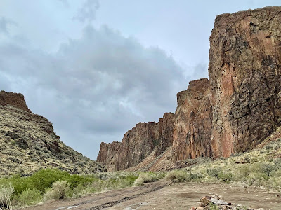 |
| High Rock Canyon |
 |
| Turn around for the day |
It was around 5 or 6 when I got to the cabin and it was already getting quite cold. I didn’t feel like cooking anything elaborate so I just boiled water and rehydrated some dried soup mix. I was in my sleeping bag by 7:00 pm and I spent the remainder of the evening reading while the wind rattled the walls of the cabin.
I was up with the sun and, yes, it was very cold. So breakfast was a quick cup of coffee and yoghurt and then I was ready to pack up and go. While taking a final look around the site before I left I found a kildeer’s nest on the ground right next to the cabin. The kildeer wasn’t on the nest but later I saw her stalking around. Hopefully I didn’t disturb her too much.
 |
| High Rock Canyon |
I had thought about the problem of the water crossing going up High Rock Canyon overnight and decided I could probably do it so I set off again up the canyon. When I came to the water I shifted into 4 Low and ran on through. My new 4 Runner performed well and while the water was up over the bottom of the door level it pushed on through and climbed out the other side without any problem. After that little obstacle there were three or four more water crossings and each one was relatively easily crossed. Of course everything is relatively easy, until it isn’t.
 |
| One of the water crossings |
Where the canyon widens out and is joined by the Yellow Rock Canyon (named after the yellow rock of the canyon walls) there is an old building, an old garage. This is all that is left of a homestead that was built in 1915 by the Fox family. The house is long gone but the garage that once housed Mr. Fox’s Essex automobile still stands and has recently been restored. It must have been an extremely difficult life as a farmer in that hostile and relatively unfertile land and that Essex automobile must have been quite sturdy.
 |
| Mr. Fox's Garage |
At the north western end of the canyon is Steven’s Camp. This is another of those cabins that have been built/maintained/upgraded by various hunters and off road people available to anyone on a first come first served basis (like my cabin of the previous night). This one is quite well equipped with bunk beds, a stove, running water, and toilets. Much better than my Little High Rock Hilton. I chatted with a group of people who were spending a few days there. There were 7 or 8 of them there. The cabin was quite large and well maintained.
I turned around at Steven’s Camp and headed back down the canyon. The road was fairly rough but not too bad. However it did have a lot of bushes on either side. I got a lot of brush pinstriping down the side of my previously unscathed vehicle. That’s a shame but it had to happen sooner or later.
 |
| High Rock Canyon |
At the bottom end of the canyon I drove further east and went down Fly Canyon. This is also a part of the Applegate Emigrant Trail. It comes out into the plain below Soldier Meadows (Mary Ann and I had camped there a few weeks earlier). From Soldier Meadows I headed south on the continuation of the trail along the west side of the Black Rock Range. This is a route we had taken on our previous trip down towards Black Rock and the Playa.
All day there had been rain showers but none of them were too serious and there was never any sign of standing water on the road. However as I got closer to Black Rock itself, I noticed that there were always more serious rain clouds hanging around the rock. As I got even closer, I ran into standing water on the road. This normally dry and dusty ground becomes very slick when it is wet and I did start to slip around quite a bit. Conditions got worse and worse and I had to get into 4 Low and use traction control to keep moving. That seemed to get me through most areas but sometimes I was slipping and sliding in a different direction to that which the wheels were pointing.
 |
| Black Rock |
This did not look good for getting across the playa to the south side of the Black Rock Playa, which was my intended route. Near Black Rock Springs I met 4 other off road vehicles and a group of guys. I slipped and slid through the mud to go and talk to them, getting my shoes thoroughly muddy in the process and then while chatting to them there was a torrential hail and rain storm - this did not look good for future progress.
I decided to take a look at the playa to see if I could get across but after a few 100 yards of muddy road I decided I should return and make my way back from where I had come. The playa itself is no place to get stuck in.
 |
| A very dirty vehicle |
I drove back north until I got on firmer ground again. At the Double Hot Spring intersection there was a road leading into the playa and it looked dry and well used. I cautiously drove out onto the playa and found it perfectly dry - the bad weather and rain was only hanging over the Black Rock itself and just a mile further north all was dry. I drove over the playa, towards Gerlach, on what was a very smooth, flat and fast track through the playa. It is great fun to ride on the playa at high speed.
 |
| Black Rock Playa |
In Gerlach I topped up the gas and then drove across the tracks and picked up the Jungo Road towards Winemucca. As I drove past the south side of the playa I could see that areas were indeed flooded and I could still see the rain clouds over the Black Rock. I was feeling rather lucky to have escaped out of that mess. If I had stayed over by the Black Rock and tried to get across I could have been stuck for days.
 |
| Sulphur |
The road east to Winemucca is relatively unremarkable. Sometimes the road parallels railroad tracks - the Feather River Route of the Western Pacific Railroad (now operated by Union Pacific), sometimes it winds through low hills and the typical Nevada Basin and Range topography. There were the occasional wild horses roaming around. I stopped to look around the site of the old town of Sulphur which was, as its name suggests, a sulphur mining town. These days there is not much to see there save for a couple of buildings and a lot of debris.
 |
| Hycroft Mine |
Just east of Sulphur is the Hycroft Mine site. This is a very large operation which is currently producing significant amounts of gold.
 |
| Pulpit Rock |
Just past the mine entrance is Pulpit Rock, a distinctive rock formation that likely was a landmark for the early emigrants to the west.
The Hycroft mine employs a lot of people and there is a lot of activity there. The road over the 50 miles to Winemucca is still dirt but it is wide and well groomed. I passed 4 busses bringing employees out to the mine on my way to Winemucca.
I stayed the night in Winemucca and took the opportunity to visit a car wash to clean my very dirty vehicle. The car wash was a bit dirty when I left.
 |
| The aftermath in the car wash |
The next day I did a quick look around Winemucca - it’s not a big town but it has the Buckaroo Hall of Fame (which was closed) and a nice little museum (which was open and well worth the visit).
On the way back to Sacramento I took a side tour to visit Unionville (50 odd miles south west of Winnemucca) which I had learned about from some article I read. It was supposed to be an old ghost town but really it wasn’t much of a ghost town - it was being repopulated with rather large and fancy homes. There were also a few Trump/Republican stickers around - not my kind of place.