Monday, December 07, 2020

Southern California Trip - November 2020

I did a nice road trip down to Southern California after Thanksgiving. After being relatively restricted in travel since coming back from the UK it was nice to get out and see some different countryside.  In the time of Coronavirus traveling was perhaps not the best of things to do but I was careful and didn’t really come into too much contact with anyone - masks all the time, food in the car, etc.

I did see some interesting places along the way however and that always makes a road trip worthwhile.

Woolworth's Bakersfield

The Woolworth's Cafeteria

First stop was in Bakersfield where there was an old Woolworth’s store complete with its original cafeteria.  Of course it is not operated by Woolworth’s, they went out of business in 1997, but it is now an antiques market but it retains its signage and its cafeteria.  I had a quick look around and bought  some old postcards of Santa Barbara.

The Kress Department Store, Bakersfield

Across the road from the Woolworths is an old department store, again now defunct and housing an antiques market, but what a beautiful art deco building.  Just a wonderful building that must have been quite grand in its day.


Traveling out from Bakersfield on Highway 58 you quickly pass through some beautiful countryside as you go up into the Tehachapis.  Bakersfield and its surrounds down in the plains of the San Joaquin Valley are quite desolate and boring but on the east side of Bakersfield it is beautiful.


Cesar Chavez National Monument 


In the foothills of the Tehachapis, in the small town of Keene, is the Cesar Chavez National Monument.  I hadn’t heard of this place and I was surprised to find it was a National Monument.  It is the place where Cesar lived in later years and from where he did his labor organization work.  It is also the place where he is buried.  The park and its facilities were closed but I did wander around a little to stretch my legs.  It is, to say the least, quite a modest park.
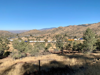

The Tehachapi Loop

Just a few miles beyond Keene, is the world famous, at least among railway enthusiasts, Tehachapi Loop.  This loop gains 77 ft in altitude over a 1200 ft diameter circle.  I think one of the first of its kind being built in 1870 by the Southern Pacific.   The sign says it is one of the 7 wonders of the railroad world.


Parked Aircraft at Mojave Airport

Beyond Tehachapi Highway 58 continues into the Mojave Desert and the town of Mojave itself.  The airport there is a favorite place to stack aircraft that aren’t needed for a while and there are plenty of those these days.  The dry moderate climate makes it a good place to warehouse planes until they are needed again - if they are to be needed again.  I poked around at the airport for a while.  There were a lot of cars there but no visible signs of people.  It appears there is some rocket research going on there too.
Joshua Tree

From Mojave I went further east to Barstow and then dropped down to Joshua Tree National Park.  The Joshua trees are just so majestic and beautiful and I always like driving through the area.  Of course in Joshua Tree Park the rocks are impressive too and I had a nice little hike around one of the trails there.


Joshua Tree National Park

For the return trip it was pretty much the same things in reverse.  I did time things just right to catch a train going over the Tehachapi Loop which made my day.  How impressive to see the front of the train pass over or under the back of the train.

Colonel Allensworth State Park


North from Bakersfield I took a detour to Colonel Allensworth State Park.  This turned out to be quite disappointing but nevertheless quite historically important.  Colonel Allensworth was born into slavery but escaped to join the Union Army in the Civil War.  After the war he became a preacher and moved west.  Among many other things he created the town named after him as the only town founded by African Americans in the West.  Now it is a collection of preserved buildings and homes in the middle of the cotton fields of the Central Valley.  The town died away after Allensworth’s death and during the Reagan governorship it was restored as a state park.  It has campsites and a visitor center but no one else was there.  There is a railway platform but you have to make special requests for a ticket before the train will stop there.


Stebbins Cold Canyon Hike

On Saturday afternoon I did a hike with Nancy in Stebbins Cold Canyon, the UC Davis maintained preserve to the west of Winters.  The loop trail here is one I had done many times before but I didn’t realize that this area had been hit by one of the recent wildfires.  The whole area had been decimated and all the fine work that UC Davis had done on creating a nice trail had been wiped out.  The trail is still there but not much else except for a few burned trees and a lot of ash.  It was strange to walk through this kind of landscape where earlier in the year it would have been a wooded trail, enclosed with shrubs and bushes and quite shady in many parts.  Now it is open and all the bushes are gone and only the odd burned tree stump remains.  Even the wooden steps that had been put in place to take the trail up the hillsides were burned.  It must have been quite the conflagration.


On top of the ridge line you could see the extent of the fire and how some slopes were untouched and others were simply denuded.  Of course Lake Berryessa to the north west looked all the more splendid in this landscape.


The hillsides without any ground cover are going to be a real issue if we get any rain.  They are quite steep and the ground is just loose dirt and ash with nothing to hold it in place.  The rain will just rush down the hillside cutting new channels and gorges in the path of least resistance.  


That being said, there were already a few signs of regrowth.  There were quite a few small scrub oak shoots poking through already.  My botanist friend later told me they were Quercus Berberidafolia.  


As we hiked along the ridge line, we heard the wailing of a dog in the valley below.  It didn’t sound like a coyote but it did sound very much like a dog in distress and it just went on and on.  I decided to investigate once I got back down to the road again.


A CHP helicopter flew over us and did several passes up and along the valley and around the ridge.  Obviously they were looking for something or someone but after a while they went down to the road below and landed in an adjacent field where there appeared to be some police action. 


As we made our way down, the helicopter came back and lowered a basket to pick up a hiker.  I thought at first it was the distressed dog they were retrieving but no, just someone who had sprained an ankle on the hillside.  Back down at the road there were fire trucks, an ambulance, and police cars.  All of that and a helicopter make for quite an operation just for a sprained ankle.  


I jogged back up the trail to try and find my “distressed dog” but the yelping had now stopped and I didn’t find any sign of the animal.  I am not sure what I would have done with a stressed out dog in the wilderness anyway.  Nevertheless it is the thought that counts.


A stop on the way back at Berryessa Brewing Company for a beer and steak sandwich from the Buckhorn’s food truck.  A perfect end to the day.


Wednesday, November 04, 2020

Western States Trail - Part 4

On election day, November 4, I again went up to do another section of the Western States Trail.  This time a shorter section from the western end of French Meadows Reservoir, or Duncan Canyon as the WS Aid Station is called, up to Robinson Flat.  Of course this required the 2 hour commute up there and then the same back for just 4 hours of running.  Still this might be the last time I have to navigate the long and winding road up to French Meadows.

The trail out from Duncan Canyon

I was on the trail just after 10.  It first wound gently up along the side of Duncan Canyon and then after a mile or so dropped down, gently to the bottom at Duncan Creek.  This was a most pleasant section - reasonable trails, good footing, no dust and gently ups and downs.  

Duncan Creek

At the bottom the trail crosses Duncan Creek which is still flowing and then starts it’s climb up for 3.5 miles towards Robinson Flat.  It didn’t seem too steep for the most part, though there were sections that made me stop to catch my breath.  On the whole it was a pretty trail through the trees up to the top and then along into the Robinson Flat campground.

Up the hill to Robinson Flat

The shorter run of 6 miles out and 6 back made it all quite enjoyable.  I didn’t have to worry about complete exhaustion or not making it back before dark.  Plus on the way back the first 3.5 miles were downhill where I could keep up a good pace.

What is that plane doing?

I was startled on the descent by this low flying plane, a military plane I believe that came swooping over the crest of the ridge and down the valley.  What on earth were they up to flying so low.

Nice Autumn Colors in Duncan Canyon

I was back at the car by 2:00 pm and whereas when I finished there the other day I was absolutely filthy with trail dust, this time I was quite clean and presentable.  That’s another section done but I am not sure I want to do more as from here on I would be in the deep canyons with some serious downhills and the corresponding uphills on the way out.


Friday, October 30, 2020

Western States 100 Trail - Part 3

After three days of rest I felt like having another go at the Western States Trail.  I set off after coffee on Thursday (29 October) for French Meadows where I planned to run back up the trail to my prior stopping place just down from Red Star Ridge (where the Soda Springs Road crosses the trail).  

It is a long drive out to French Meadows of around 2 hours.  It  crosses from the Foresthill Ridge down to the bottom of the North Fork of the American River and then back up to Mosquito Ridge.  The North Fork Canyon is a most impressive sight.  It is primarily forested but it is dramatically steep and incredibly immense with this rather fine tarmac road winding down one side and up the other.  What an awe inspiring sight.

The dam at French Meadows

I didn't get on the trail until 10:00 am and it was already getting warm (as opposed to the previous venture when it was fairly cool all day).  The first part of the trail from here is uphill and a bit of a slog.  I passed some hunters - one a young guy with bow and arrows - the other an old couple with rifles, they must have been around 80.  I chatted with the couple for a while and I showed him my photo of a paw print from my previous run. With supreme confidence he confirmed it as a coyote, a large coyote.  Not a mountain lion, not even a bobcat.  What a relief.

The view to the East from the top of the ridge


The trail continued up to the top of the ridge and then pretty much followed the ridge line, undulating up and down along the way.   The trail was very dusty and rubbly so while some of it was ok running there was a lot of picking the way through rocks and a lot of dust,  It appears people take motorbikes up on the trail, they shouldn’t they are banned, and these really tear up the trail particularly around the hairpin bends of a switchback leaving them this time of year as a heap of fine dust.  Probably better than what happens in the rainy season.

Mainly Trees on this section

As usual around 8 miles out I start getting tired, wondering if I can make it, and then when I get to my turnaround I have a great sense of relief.  The fatigue continues (depending on the grade of the trail) for a while until I finally get my energy back 3 of 4 miles from the car.  I think my last 2 miles were the fastest of the day.  Every time I do this I say to myself I don’t need to do this again, it is misery, I am too old for this, but then there is a sense of satisfaction upon completing it that is hard to beat.
Forest regrowth

There were some sections of regrowth after a fire some years back.  It is amazing how the forest grows back after the devastation of a fire.  The forest floor was carpeted with small fir trees about 4 or 5 ft tall.

The dusty terrain caused my shoes to fill with dust and that got really painful after a while.  I had to stop three times to empty my shoes and beat out my socks before continuing.  That became a real chore after a while but the relief with dust free shoes was well worth it.

Back at the car I was really filthy - arms, legs, feet all covered in dust.  I did the best I could to clean off before changing clothes for the drive home. 


Stopping in Foresthill for something cold to drink I went into the gas station where I was the only one wearing a mask.  Just what you would expect in this land of Trump signs.


Tuesday, October 27, 2020

Western States 100 Trail - Part 2

I didn’t have much going on at the weekend so I decided to attempt another section of the Western States 100 trail.  This time I was going to camp somewhere near the trail and hopefully run into the Granite Chief Wilderness to spot where I left off last time.  

On Saturday afternoon, I drove in the Land Cruiser up to the eastern end of French Meadows Reservoir.  That is about 100 odd miles and it takes nearly 3 hrs.  I had intended to camp in the Talbot camp and then drive up the trail the next morning to find the Western States Trail.  However, after all the fires in California, all the campgrounds were closed so I had to find a clearing on the side of the trail and camp there for the night.  


The camp spot

I say camp, I camped in the car and stretched out on the back of the Land Cruiser.  Not much headroom, but it is warmer and a whole lot easier than pitching a tent.  By the time I got situated it was gone 6:00 pm so all I had time to do was cook (reheat) a little food and then get ready for nightfall.  By 7:00 pm it was bitterly cold and I was in my sleeping bag inside the car.  That meant it was going to be a long night ahead - I read for a while, I slept for a while, I read a while more in the middle of the night and I extricated myself from the sleeping bag when the sun came up around 7:00.  

A quick breakfast and it was off to find the trail.   According to the map the fire road out of the Talbot area intersected the trail somewhere up the hill.  However before we got too far the road we got to the boundary of the Granite Chief Wilderness Area and the road was closed off with boulders and downed trees.  They don’t want vehicles going into the Wilderness area - I guess I should have realized that.


End of the Road

So that didn’t bode well so I backtraced down the hill and consulted the map again.  There was another road to the west that also crossed over the trail and I knew that road so I thought I would give that a try.  I thought it would be too far to the west to allow me to run to my last stopping place in one day though.  I wanted to keep the miles under 20.

I parked up at the trail crossing and set off up a nice gently uphill trail to Red Star Ridge.  It was cold but not too cold.  After a mile or so the trail merges with a road and I believe that is where there is an aid station.  There were a couple of hunters up there that I chatted to for a while.  Apparently it is deer hunting season.  Hopefully I don’t look much like a deer.


The trail into the Granite Chief Wilderness

The trail in this section is quite nice.  Not too steep for the most part.  Up and down but quite runnable and the views are spectacular.

I carried on the ridge top trail for 5 or 6 miles enjoying every bit of the trail.  It was beautifully sunny but the wind was blowing, and the wind was cold.  A sign that we are getting close to winter and it’s not the place to be in a T-shirt and shorts in winter.   The trail dropped down a fairly steep hill and I came across a couple more hunters camping at the bottom of the hill.  They hadn’t seen any deer but judging by their garbage pile they had consumed a lot of beer the night before.  Nice guys though - we chatted for a while.


I continued on and crossed a road that comes in from Soda Springs and then a really nice bit of flat wide running trail.  Just lovely.  I was thinking about what my turnaround time should be and had decided that 1:30 was the time and that would give me a couple of hours daylight cushion if I slowed down on the return.  Then around 12:45 things started to look familiar and all of a sudden I was at the point I stopped last Wednesday.  That was a good feeling to not have to push things too far.

Deja Vu all over again


The return wasn’t so bad.  Other than one long steep uphill most of the trail was sloping the other way, downhill.  I did become perturbed by a new set of animal tracks on the trail that weren’t there on my way out.  A footprint with 5 pads not quite as big as a mountain lion.  At least that’s what I was hoping.  I did however pick up a rock to act as my weapon if I was attacked by this unknown animal.  The tracks stayed with me on the trail for a good 5 miles.


Bobcat, Coyote, Labrador?

At the end of the day I was getting a little tired and a little cold.  All day the wind had kept blowing and it was now nearing 4:00pm and it was getting cold.  It was a nice sight to see the Land Cruiser appear in the trees and the end of what was a 17 mile run for the day.

A most welcome sight

I came out by continuing north to Robinson Flat and then out the Foresthill Divide Road to Foresthill and Auburn.  A great day but perhaps the last one for this year.  Winter is on the way.

Western States 100 Trail - Part 1

Back in the USA in October and with the Coronavirus issue still impacting our lives I started to look for another challenge.  Completing the TRT earlier in the summer made me think of another run and what I came up with was completing the bits of the Western States 100 mile Trail that I hadn’t already done.  

I had done the pieces from Foresthill to Auburn many times but had not ventured on the beginning part in the high sierras.  This was not going to be so easy as the TRT as some of the parts in the first 60 or so miles are quite remote and of course everything would have to be done as an out and back to get me back to my transportation.


The base of Squaw Valley
On Wednesday, 21 October I decided to make a start and I drove up in the early morning to Squaw Valley to do the first 10 miles of the course.  It was already cold up there and at 8:00 am my car registered 32 degrees.  So there was a definite chill in the air as I started up the trail from the Ski Resort.  I didn’t get far before I came across a sign across the road - Stop - this road is closed to all foot and bicycle traffic.  Well that was just not on.  I couldn’t have come so far to be stopped by a sign so I pretended not to see it and off I went.  There were quite a few Squaw Valley trucks going up and down the road but no one said anything - we just waved at each other.


The view from the bottom of the trail is quite intimidating as all roads go up and fairly steeply at that.  It is 6,200 ft at the base and it rises to 8,750 ft at the top.  That is 2,550 feet in 4.5 miles.  It also gets a bit complicated as to which is the correct road to take.  The ski resort is a myriad of roads leading to the various lifts and lodges and work areas and apart from one sign I didn’t see a single mention of the Western States trail.  Fortunately I had sprung for a subscription to the All Trails iPhone app the night before and that had a course marked on it which allowed me to follow the approximate route.  The map however was just a series of straight lines between various way points and in some places there weren’t many way points so again it was easy to get off course - which of course I did.

All roads are uphill

The ski resort is huge - it is the largest in California - and unfortunately in the denuded landscape of ski slopes at the end of summer it is not that pretty.   Monster lifts are everywhere and snow making machinery peppers the slopes not to mention the 3 or 4 large lodges.  To be honest it is a bit of an eyesore.

Approaching the Emigrant Pass


As you can imagine the run was not much of a run, it was a brisk walk with lots of stops to check the route and get my breath back.  Near the top I struggled to find the pass over to the other side.  The route I was following seemed to be taking me to the top, then all of a sudden I was too far south.  I corrected and went back and then I was too far north.  I almost gave up until I took the time to study the map more carefully.  I finally figured it out and I made it up the last slope to the pass, Emigrant Pass, where there is a monument marking the spot but not visible until you are right on it.  

Emigrant Pass

It was a pleasure to be done with the ascent for a while and there was a gentle downhill from there into the Granite Chief Wilderness Area.  It was the end of summer and the slopes were covered with dried Corn Lily leaves.  When the wind blew, the leaves rustled in an eerie way making me look around for mountain lions waiting to pounce.   I had just watched a YouTube video of a hiker being threatened by a mountain lion so I was a bit more aware.  I decided I needed a weapon and I found a sharp angular piece of granite that just fit in my hand that I thought would give me some sort of ability to defend myself.  I had also been talking to one of my fellow runners about letting the lions know you are coming by singing or shouting or letting out some noise.   Running with Tourette’s she calls it.  My voice is not strong at the best of times so I soon gave up on that.


Granite Chief Wilderness

The trail through the Granite Chief was not particularly good - it was narrow and twisty, rocky and rubbly and just difficult to run.  I had expected it to be more well defined and well used and more runnable.  Still the countryside was beautiful and the trail traversed along the south facing side of the valley dropping down along the way.

The turnaround spot

I had determined that I would do around 10 miles out that day which should have taken me to somewhere near the Lyon Ridge Aid Station.   I wasn’t really sure I had found the aid station area as there are no roads in there but after just over 10 miles I decided to call it a day and head back.  I made it out in 4.5 hrs which I was surprised to find was 1 hour under the cutoff on race day.  The big difference being, I was pretty tired and running another 95 miles was not on the books for me.  In fact running back up the trail things deteriorated.  I got very tired and while much of the trail was not steeply downhill, there were parts that were and they seemed to be more common than I had noticed coming down the hill.  I didn’t enjoy this section at all and I kept going over the options of what to do if I just couldn’t make it back up the hill.  There were no good options in that scenario.


Granite Chief Wilderness


So it was a slow and tortuous struggle to get back up the hill to Emigrant Pass.  I did lots of resting and very little running.  It was slow going but eventually I did make it up the last bit of slope to Emigrant Pass.  It was nice to then make some better progress jogging down the trail for a while.  Of course I again got off track and had to bushwhack across the hill to get to the road that would take me down.  This time I took the more main road on the way down (longer distance but not so steep).  The long downhill jarred the joints and punished the feet in my grit filled shoes but I eventually made it and jogged into the parking lot of the resort.  


The remains of my still warm coffee from the flask and a clean shirt and socks made me feel a lot better.  I drove home and got in around 8:00 pm.  That was 14 hours door to door.  9.5 hrs out on the trail for only 20 miles.   That looks pathetically slow but I know it was some serious achievement for little old me.


Monday, October 05, 2020

Berlin - September 2020

Following on from my trip to Milan and then Zurich I caught the overnight train from Zurich to Berlin.  It was a pleasant enough journey through the night and I arrived in Berlin right on time at 8:00 am.  Berlin’s Hauptbahnhof is an impressively modern train station with multiple levels of train tracks, shops, restaurants and cafes.  My hotel, the Ibis, was right outside the station so I walked over to leave my bag while I explored the city.  To my surprise they let me check in and it was not even 9:00 am.  That was unexpected and quite nice.

Berlin Hauptbahnhof

I set off to explore the town but since I had been here a couple of times before I was not too inspired to see anything in particular.  I had read about the graffiti and mural art in an area by the Ost Bahnhof, so I decided to head that way.  Walking didn’t feel too attractive to me so I rented another scooter. 


Berlin is really good at accommodating bicycles and scooters.  There are many cycle lanes and cycle paths and the city is just full of cyclists.  You have to be careful as a tourist if you are not accustomed to silent bicycles speeding by you.  They have separate paths which I kept confusing with footpaths only to find that a bicycle has the right of way and could indeed take you out.  The real nice thing though is that for the most part the bicyclists follow the rules of the road and stop at stop signs and keep to their paths.  If only that were the case in the USA.


To get over to the Ost Bahnhof, I could more or less follow the banks of the River Spree all the way.  It is a scenic and interesting route too, taking me past the Parliament buildings and the Reichstag and on towards Museum Island.  On the northern tip of Museum Island is the Bode Museum.  I didn’t go in but I did admire the wonderful building.

The Bode Museum

I crossed over to the north side of the Spree and continued along through the main roads to the East Side Gallery.  The East Side Gallery is a section of the Berlin Wall on Muhlenstrasse where artists were invited to decorate sections of the East side of the Wall.  That was back in 1990; 30 years ago now.  The border between the East and the West was actually the River Spree itself so this part of the wall was rather small and to my eyes easily scalable.  However you would have to have first made it across the Spree and no doubt there were plenty of guard towers.   Since the original artwork was done there has been significant deterioration from plain old weathering to graffiti and vandalism. There have been attempts to restore and preserve the works (not without controversy) and for the most part it is now in reasonable condition (except for the graffiti tagging).  


I particularly liked the red jacketed wall jumper, the Detour to the Japanese Sector, the Andrei Sacharov portrait and of course the Brezhnev - Honecker Kiss.


By this time I had been using my scooter for an hour and apparently after 60 minutes they terminate the rental, at least they do if it is stationary and locked as mine was at the time.  I continued on for a while on foot, crossing over to the south side of the Spree and back towards the center on Kopenicker Strasse. I was not really in the mood for walking so I rented another scooter for the journey back.  They are relatively easy to find in this city - they are scattered everywhere. I followed the south side of the Spree back to the Hauptbahnhof and my hotel.


I had a quick lunch in a nearby restaurant and then decided to rent a bicycle for the afternoon’s explorations.  The scooters, while fun, were getting to be quite expensive.  My morning’s travels amounted to 25 euros.  I rented a bicycle from the hotel for the entire afternoon for just 8 euros.  

The Brandenburg Gate

I wasn’t sure where to go in the afternoon but I had read about the old Tempelhof Airport in the south of the city and I thought that would make a nice trip.  I traversed across the city seeing many of the sights on the way - the Reichstag, the Brandenburg Gate, Under den Linden, Potsdamerplatz, Alexanderplatz.  I was getting the hang of this cycling and scootering by now, and feeling quite comfortable riding in traffic.


The Tempelhof Airport buildings are immense - it was once among the top 12 largest buildings in the world.   While the airport did exist earlier, much of the airport was built during the 1930s as part of Hitler’s and Albert Speer’s plan for the new Germany and it was in this pre WWII period that the airport grew. Of course it’s real claim to fame for me was the role it played in the Soviet blockade of Berlin in the post war era.  There was a tremendous amount of traffic coming in and out of the airport during this period to supply food and other resources to the inhabitants of West Berlin.

Tempelhof Airport Hangars

There is an arc of huge hangar buildings, now mostly not in use but they are certainly impressive.  I do believe that you can do tours in more normal times but alas all I could do was ride around the exterior.  I did get to go into one section that was opened as a sports center with tennis courts, basketball courts, etc. and that got me out to the runway area.  There is an old USAF plane parked in front of the terminal - a C-47 perhaps as that was the primary plane used in the airlift.  They were called "raisin bombers" as the pilots and crew often dropped sweets as they came into land for the children who would wait by the airport fence.

Tempelhof Airport

After seeing all I could, I headed back northwards to the hotel passing all the landmarks again.  This time I detoured past Checkpoint Charlie which was remarkably quiet in this Coronavirus world. Just down the street from the Checkpoint was Traby World, where you can arrange to be driven around town in a Trabant, that iconic East German car.


In the evening I had a lovely Italian meal in a restaurant near the station and then retired to my room to ready myself for the early morning bus to the airport.  Even at 5:00 in the morning the buses were running every 10 minutes to the Tegel airport and what is more, the ride was free.  Whether that was a normal situation or just because of Coronavirus I do not know.  My flight left a few minutes late and I was in London an hour or so later.  From there it was on to San Francisco and home.


There are more photos here.