Tuesday, March 30, 2021

Death Valley - March 2021

At the end of March Mary Ann and I decided to go on a road trip to Death Valley together.  March/April is the best time to visit the park as it is not too cold and not too hot and since it was also my 70th birthday weekend it made sense to get out of town to avoid the rapturous celebrations that would no doubt be taking place.  I also wanted to do a final trip in my Land Cruiser before selling it and Death Valley would be a great place to exercise it for the last time.


Mono Lake and the White Mountains

On Saturday morning (20 March 2021) we set off in the damp and the rain and made our way up I-80 to Tahoe and out to Spooner Summit and down to highway 395 into Nevada.  By the time we had reached the Lake the bad weather was behind us and we had fine weather for the rest of the day.  We drove down 395 through Bridgeport, past Mono Lake, which was looking spectacular, and on to Mammoth Lakes.  At Mammoth we turned east on Benton Crossing Road and headed over to our overnight stop in Benton Hot Springs.  Benton Hot Springs is an interesting place.  It is just a few old buildings, now mostly deserted and derelict but it has a hotel and we had a room there for the night.  It was the quirkiest hotel I have stayed in for a while.  We had the cowboy room with a wonderful mural above the bed and all sorts of cowboy and Native American artifacts in the room.  


Benton Hot Springs Hotel

The hotel has several hot pools around the property and the hot water for the hotel and the underfloor heating all comes from the hot springs.  They actually have to cool down the water in a tank for the hotel’s cold water supply.  That evening we dined al fresco on the patio of the hotel and soaked in the hot tub behind our room.

Benton Hot Springs

The next morning we set off towards the northern entrance to Death Valley.  We gassed up in Dyer and then entered the park via Eureka Valley.  A couple of burritos strategically placed on the engine before we left our hotel provided us with a nice warm breakfast on our way into the Eureka Valley.

Eureka Dunes

The Eureka Dunes at the southern end of Eureka Valley are quite tall and impressive - significantly larger than any of the other dunes in the park.  From the Dunes we headed up towards Dedeckera Canyon and Steelhead Pass.  As we passed by the south side of the dunes we were startled by a pair of C-130 Transport planes flying low, very low, over the road.  The Air Force uses the valleys around Death Valley for its low altitude flight training.
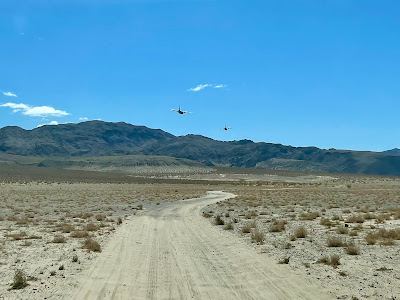
Low Altitude Flight Training

Dedeckera Canyon has a few tricky spots on its ascent to Steelhead Pass but the Land Cruiser handled them perfectly.  On the way down the other (south) side of the pass there is a strange installation - up an unmarked side canyon, a bath tub sunk in the ground and filled with blue marbles.  Who put that there and why they did it, no one knows.  It’s just one of the things that makes Death Valley so interesting.

Blue Marble Bath

Heading down the trail into the Saline Valley we came across a hiker.  I first thought he was wearing a too short pair of shorts, but no, as we got nearer we found that he was not wearing any shorts at all - just a T shirt and a pair of hiking boots, nothing else.  Death Valley attracts the strangest of people.

Saline Valley Hot Springs

We set up camp for the evening at the Upper Saline Valley Hot Springs.  There were quite a few folks there already so we found a more secluded spot to pitch our tent.  We didn’t go into the hot springs as they seemed to be quite busy and there were way too many naked old men around.  Instead we dined on a fine meal of Spaghetti Bolognese and retired to the tent.  In the night I was awoken by a burro walking by the tent - he didn't come in.  There are quite a few burros around in the valley.  They were left there by the miners and they have been quite successful in their breeding.  The park has a plan to remove them as they are considered non-native invasives.

Fine Dining in Saline Valley

The next morning we packed up and prepared to drive south down the Saline Valley.  Before we left camp we had a fun discussion and education on the ways of Hot Spring Life from Denis, a colorful and very chatty character who puttered around the springs on his motorbike.


Denis and his motorbike

The road south is a washboard road that is not much fun to drive on but the valley is beautiful in a Death Valley barren and extreme kind of way.  We passed the site of an old tramway that was built in 1911 and operated until 1930, that transported salt gathered from the valley floor up and over into the Owens Valley where it was shipped further afield.  Very little remains of the tramway now, just a few old towers out in the salt flats, but what an impressive operation that must have been.


Lippincott Pass down to Saline Valley

At the foot of Lippincott pass we dined on another engine warmed burrito before making the ascent up the pass and over into the next valley, Racetrack Valley.  In the bottom of this valley is a playa, the Racetrack, that displays a strange and unique phenomenon.  There are several fairly large rocks that show tracks of their movement across the playa.  The tracks of the stones are many yards long and for a long time no one knew how they were created.  However, scientists have recently discovered it was a combination of ice, followed by the melting of the ice at a time of very strong winds with of course a very flat playa.

Moving Rocks on the Playa

At the northern end of the valley is Tea Kettle Junction.  A place where people adorn the road sign with various tea kettles.  Judging by the messages on them it looks like they are mostly recent additions.  Perhaps the Parks Service removes them periodically and people slowly replace them.

Tea Kettle Junction

It was then more of the washboard road up to Ubehebe Crater.  This is a magnificent volcanic crater created by an eruption of steam (a phreatic crater) and it is nearly ½ mile wide and some 700 ft deep.  The date of the eruption is not clear but it may be quite recent - 700 to 2000 years ago.
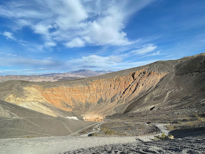
Ubehebe Crater

From Ubehebe we joined the tarmac road through the valley so we aired up and sped along through Furnace Creek and out towards Death Valley Junction.  On the way we stopped at Zabriskie Point to view the beautiful erosional landscape there.  It was close to sunset and the place was quite busy with everyone snapping a photo of the great light conditions at that time of day.

Zabriskie Point
We stayed the night at the Amargosa Opera House Hotel in Death Valley Junction.  This is quite an interesting place.  It was originally the accommodations for executives and investors associated with the local borax mining operations.  When the industry failed in the 1940’s it fell into disrepair until a Marta Becket, a Broadway performer and ballerina, happened to see it and decided to buy it.  She decorated it with her murals (she was a talented artist), opened it as a hotel and began performing there in the associated meeting room now called the Opera House regardless of whether she had an audience or not.  Her last performance was in 2012.

The Amargosa Opera House Hotel

The hotel is struggling now and it is quite run down.  Death Valley Junction is a long way from Death Valley itself and there is nothing else in the town.  A non-profit is trying to keep the hotel alive but it needs a lot of upkeep and some serious renovation money to make it viable.  That being said we enjoyed our stay in this most quirky of hotels.  Sadly because of Covid the Opera House itself was closed so we could not see the murals that Marta painted in there.


The Amargosa Opera House

Our next day we headed north from Death Valley Junction up towards Beatty.  Beatty is an old mining town and it is the largest population center on the east side of Death Valley.  It has a few hotels, a couple of casinos, gas stations but surprisingly no grocery store.  I don’t think there are many fresh vegetables eaten in Beatty.  After gassing up, we headed west and entered Titus Canyon.  I had been to Titus Canyon a couple of times before, most notably to run the Death Valley Marathon in 2008, and I always enjoy it.  The views at the head of the canyon are spectacular and the canyon itself is wonderful as it narrows down before emptying out into Death Valley itself.

Titus Canyon

After we got out of Titus Canyon we drove south through Furnace Creek, stopping briefly at the Devil’s Golf Course to see the weird wind driven salt formations, and Badwater the lowest spot in the USA at 282 ft below sea level.  Then it was down to the southern end of Death Valley and up Warm Springs Canyon to Butte Valley.  The wind was really blowing hard and the views at the southern end of the valley were obliterated with blowing sand.  We got out to air down the tires at the start of Warm Springs Canyon and got abraded with fine sand.  Not an environment you want to be outside in for too long.

Blowing Sand in Death Valley


We stopped to examine a couple of mining operations on the way up Warm Springs Road, some perhaps quite recent, and then climbed over the pass into Butte Valley.  Butte Valley is named after the striped rock butte that sticks up in the middle of the valley.  I had hoped to stay that night at the Geologist’s Cabin that overlooks the valley but someone had already taken up residence there so we moved on.  A short distance away is Stella’s Cabin and we stayed there.  There are several of these cabins around the more remote spots in the Valley.  Usually old miner’s cabins that have been retrieved from total deterioration by fellow off roaders.  The idea being that they are made available on a first come first served basis with an understanding that you try and leave the place a little better than you found it.  Stella’s Cabin had a wood stove and a good supply of wood, a table and sink for cooking, an old refrigerator (not functioning) for non perishable food storage and most of its windows were still intact.  It provided a great shelter from the winds that night.  The tent would not have been a good place.


Stella's Cabin

The next morning was beautiful and calm and we dallied a long time over breakfast admiring the views over Butte Valley.   Mary Ann did a wonderful job of sweeping out the cabin making it look a lot better and we left some food in the refrigerator for any subsequent visitors.  The road from the cabin then went over Mengel Pass and dropped down into Goler Canyon.
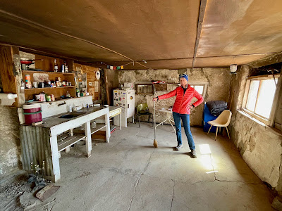

Stella's Cabin

Goler Canyon is the home of Barker Ranch, a one time ranch house that was first a miner’s cabin and then the retreat for a family, the Barkers, from Oklahoma.  It is now more famous for being the place where Charles Manson was arrested back in 1969.   Alas the once impressive looking ranch house burned down in 2009 and it is now only a shell.

The remains of Barker Ranch

Surprisingly there was quite a lot of water down the lower part of Goler Canyon and it was nice to see some green trees and bushes for a change.  On the way down the canyon we saw several burros wandering around and then a couple of big horned sheep.  The latter were quite spectacular and didn’t seem too perturbed by our presence.

Bighorn Sheep

The canyon empties into the lower end of the Panamint Valley and from there we drove north to Ballarat.  There’s not much happening in Ballarat, though the store/trading post there has been cleaned up a little and the owner now sells a few trinkets and T-shirts.  The truck belonging to Tex Watson (of Charles Manson gang fame) with the stars painted on the interior roof of the cab is still sitting there.

Tex Watson's Truck in Ballarat

Traveling further north in the Panamint Valley we took the side road to Wildrose Canyon to see the charcoal kilns there.  They are quite beautiful structures - 10 of them all lined up in a row - and they are very well preserved.

Wildrose Charcoal Kilns

That was the end of our Death Valley adventure and we drove out of the park that evening through Panamint Springs up and over to highway 395 where we stayed the night in the very fine Trails Motel in Lone Pine.  That evening we had our first meal inside a restaurant in over a year.  It wasn’t a particularly good meal but it was nice to sit inside a restaurant for a change.  The seating was limited and the waitress at least had her mask over her mouth, but sadly not over her nose.


The next day we awoke to a magnificent view from our hotel room over to the High Sierras (room no 5 at the Trails has the best view).  The entire trip has been one great view after another and this one was surely one of the more remarkable.  One of those peaks up there was Whitney, the highest point in the lower 48.  We also awoke to the smell of patchouli blowing in the wind.  The owner of the hotel, an Indian gentleman, was burning a clump of joss sticks outside his office - a nice touch.


The High Sierras behind the Alabama Hills near Lone Pine

Driving north we skipped the Lone Pine Movie Museum, and the Manzanar Internment Camp and landed in Bishop at Schatt’s Bakery where we bought bread, sandwiches for lunch and had our breakfast outside the bakery.  The bakery does an incredible trade even in these Covid days.  The staff all looked over worked and over stressed however - perhaps it is not a great place to work.


Driving north on 385 I was hoping to get into the ghost town of Bodie.  I have been there lots of times and it never fails to amaze me, and Mary Ann had never been so she needed to see it.  The main road to Bodie was closed but I had hoped the southerly entrance from the north side of Mono Lake would be open.  Alas they were working on the road and it was closed off.  Plan B was to then try and find the miner’s cabin at Bass Camp so we set off into the hills to the east of Mono Lake.  We bounced along for a while and Mary Ann had a taste of off road driving but Bass Camp was too far away so we abandoned that idea and turned back towards Mono Lake.  We did see a lot of wild horses in this section so we did get to complete the trifecta of large Nevadan mammals on this trip - the burro, the bighorn sheep, and the wild horse.

.

Wild Horses

We stayed this last night of our trip in Bridgeport where it was snowing.  Poor old Bridgeport was struggling through the Covid pandemic.  Most things were closed and when we walked out in the evening the only place open was the convenience store at the gas station.   With the snow coming down it looked quite bleak.


Next morning we had one more attempt to get into Bodie, this time from the northern route but after climbing a good way up into the Bodie Hills and getting quite close to the town we decided to turn back.  The snow was getting quite deep and there were no tracks going further up the road.  We didn’t want to finish our trip by being marooned in the snow outside Bodie.


Snow in the Bodie Hills

The drive up 395 to highway 50 was uneventful apart from a Bald Eagle sighting as we climbed up to Spooner Summit.  We were home just after 2;00pm.  Another great trip and the Land Cruiser performed wonderfully.   Should I really sell it now?

There are more photos here. 

Thursday, February 25, 2021

Weimar Trails, Graves and the Sabbath

In this time of Covid restrictions I have been enjoying the runs with friends and the discovery of new trails in interesting places.  One Sunday at the end of February, Mary Ann showed me a new trail up in her part of the world, Auburn.  It was in Weimar which is a small settlement a few miles east of Auburn on I-80.  I have passed it thousands of times but never really taken the time to look around. 

Weimar which was given its name by the descendants of the founder of the town who came from the Weimar area of Germany was the home of the Weimar Sanatarium which is now the Weimar Institute, now owned by the Seventh Day Adventist Church.   At the entry to the Institute you can gain access to the trails of the area.  The wooded hilly trails are wonderful examples of Sierra Foothill trails - shady for the most part, single track and primarily for walkers and runners - no mountain bikers (that we saw).  


We ran on the Frontier Trail, a trail that runs around the perimeter of the area.  It winds up and down through the forested hills and eventually it loops back to the Institute where it passes through an old cemetery.  A large cemetery with around 1500 graves spread out across the hillside in orderly rows.  Apart from three or four graves that were named and had more modern stone markers all were simple wooden plaques identified only by a number. 


The Weimar Sanatorium was built to provide treatment and isolation for poor and indigent tuberculosis patients in the early part of the 20th century.  TB was quite the scourge in its day being much worse than say the AIDs epidemic in our later time period.  It was contagious so patients needed to be isolated in specific TB hospitals such as the one at Weimar.  

This being a hospital for indigent patients, when they died they often did not have the funds to take care of the burial so they were buried in simple graves behind the hospital.  I guess this is what you would call a Potter's Field.


In the 1950's and later better treatments for TB were found and the need for a specialist isolation hospital was no longer required.  The hospital changed to a more general health center for the community until in 1972 it was closed.  It served as a relocation center for Vietnamese refugees for a while before it was purchased by the Seventh Day Adventist Church.

At the end of our run as we entered the old hospital area we came across some 30 or more granite boulders each with polished surfaces bearing inscriptions.  They were obviously part of a work in progress for the Seventh Day Adventists.  Most of the inscriptions dealt with the Sabbath and honoring the Sabbath and what happens when you don't honor the Sabbath.  With so many boulders, it is obviously going to be quite a large installation and it is being done at no small cost.  It left me wondering why so many (nearly all in fact) of the inscriptions dealt with the Sabbath day.  Surely their religion has a bit more to offer us than just warnings about resting on the Sabbath, which is Saturday in their religion.  

As a retired person I am pretty much a Seven Day Adventist myself.


Finally for a bit more distance at the end of the run we ran along the irrigation canal.  There is a network of these canals throughout the area, delivering water to rural homes where they don't have piped city water.  It is significantly cheaper than drilling a lot of individual wells.  Being almost level with a nice border trail they make for a pleasant run.


Monday, December 07, 2020

Southern California Trip - November 2020

I did a nice road trip down to Southern California after Thanksgiving. After being relatively restricted in travel since coming back from the UK it was nice to get out and see some different countryside.  In the time of Coronavirus traveling was perhaps not the best of things to do but I was careful and didn’t really come into too much contact with anyone - masks all the time, food in the car, etc.

I did see some interesting places along the way however and that always makes a road trip worthwhile.

Woolworth's Bakersfield

The Woolworth's Cafeteria

First stop was in Bakersfield where there was an old Woolworth’s store complete with its original cafeteria.  Of course it is not operated by Woolworth’s, they went out of business in 1997, but it is now an antiques market but it retains its signage and its cafeteria.  I had a quick look around and bought  some old postcards of Santa Barbara.

The Kress Department Store, Bakersfield

Across the road from the Woolworths is an old department store, again now defunct and housing an antiques market, but what a beautiful art deco building.  Just a wonderful building that must have been quite grand in its day.


Traveling out from Bakersfield on Highway 58 you quickly pass through some beautiful countryside as you go up into the Tehachapis.  Bakersfield and its surrounds down in the plains of the San Joaquin Valley are quite desolate and boring but on the east side of Bakersfield it is beautiful.


Cesar Chavez National Monument 


In the foothills of the Tehachapis, in the small town of Keene, is the Cesar Chavez National Monument.  I hadn’t heard of this place and I was surprised to find it was a National Monument.  It is the place where Cesar lived in later years and from where he did his labor organization work.  It is also the place where he is buried.  The park and its facilities were closed but I did wander around a little to stretch my legs.  It is, to say the least, quite a modest park.


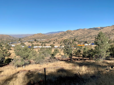
The Tehachapi Loop

Just a few miles beyond Keene, is the world famous, at least among railway enthusiasts, Tehachapi Loop.  This loop gains 77 ft in altitude over a 1200 ft diameter circle.  I think one of the first of its kind being built in 1870 by the Southern Pacific.   The sign says it is one of the 7 wonders of the railroad world.


Parked Aircraft at Mojave Airport

Beyond Tehachapi Highway 58 continues into the Mojave Desert and the town of Mojave itself.  The airport there is a favorite place to stack aircraft that aren’t needed for a while and there are plenty of those these days.  The dry moderate climate makes it a good place to warehouse planes until they are needed again - if they are to be needed again.  I poked around at the airport for a while.  There were a lot of cars there but no visible signs of people.  It appears there is some rocket research going on there too.
Joshua Tree

From Mojave I went further east to Barstow and then dropped down to Joshua Tree National Park.  The Joshua trees are just so majestic and beautiful and I always like driving through the area.  Of course in Joshua Tree Park the rocks are impressive too and I had a nice little hike around one of the trails there.


Joshua Tree National Park

For the return trip it was pretty much the same things in reverse.  I did time things just right to catch a train going over the Tehachapi Loop which made my day.  How impressive to see the front of the train pass over or under the back of the train.

Colonel Allensworth State Park


North from Bakersfield I took a detour to Colonel Allensworth State Park.  This turned out to be quite disappointing but nevertheless quite historically important.  Colonel Allensworth was born into slavery but escaped to join the Union Army in the Civil War.  After the war he became a preacher and moved west.  Among many other things he created the town named after him as the only town founded by African Americans in the West.  Now it is a collection of preserved buildings and homes in the middle of the cotton fields of the Central Valley.  The town died away after Allensworth’s death and during the Reagan governorship it was restored as a state park.  It has campsites and a visitor center but no one else was there.  There is a railway platform but you have to make special requests for a ticket before the train will stop there.


Stebbins Cold Canyon Hike

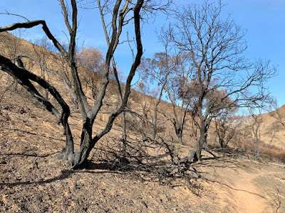
On Saturday afternoon I did a hike with Nancy in Stebbins Cold Canyon, the UC Davis maintained preserve to the west of Winters.  The loop trail here is one I had done many times before but I didn’t realize that this area had been hit by one of the recent wildfires.  The whole area had been decimated and all the fine work that UC Davis had done on creating a nice trail had been wiped out.  The trail is still there but not much else except for a few burned trees and a lot of ash.  It was strange to walk through this kind of landscape where earlier in the year it would have been a wooded trail, enclosed with shrubs and bushes and quite shady in many parts.  Now it is open and all the bushes are gone and only the odd burned tree stump remains.  Even the wooden steps that had been put in place to take the trail up the hillsides were burned.  It must have been quite the conflagration.


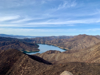
On top of the ridge line you could see the extent of the fire and how some slopes were untouched and others were simply denuded.  Of course Lake Berryessa to the north west looked all the more splendid in this landscape.


The hillsides without any ground cover are going to be a real issue if we get any rain.  They are quite steep and the ground is just loose dirt and ash with nothing to hold it in place.  The rain will just rush down the hillside cutting new channels and gorges in the path of least resistance.  


That being said, there were already a few signs of regrowth.  There were quite a few small scrub oak shoots poking through already.  My botanist friend later told me they were Quercus Berberidafolia.  


As we hiked along the ridge line, we heard the wailing of a dog in the valley below.  It didn’t sound like a coyote but it did sound very much like a dog in distress and it just went on and on.  I decided to investigate once I got back down to the road again.


A CHP helicopter flew over us and did several passes up and along the valley and around the ridge.  Obviously they were looking for something or someone but after a while they went down to the road below and landed in an adjacent field where there appeared to be some police action. 


As we made our way down, the helicopter came back and lowered a basket to pick up a hiker.  I thought at first it was the distressed dog they were retrieving but no, just someone who had sprained an ankle on the hillside.  Back down at the road there were fire trucks, an ambulance, and police cars.  All of that and a helicopter make for quite an operation just for a sprained ankle.  


I jogged back up the trail to try and find my “distressed dog” but the yelping had now stopped and I didn’t find any sign of the animal.  I am not sure what I would have done with a stressed out dog in the wilderness anyway.  Nevertheless it is the thought that counts.


A stop on the way back at Berryessa Brewing Company for a beer and steak sandwich from the Buckhorn’s food truck.  A perfect end to the day.


Wednesday, November 04, 2020

Western States Trail - Part 4

On election day, November 4, I again went up to do another section of the Western States Trail.  This time a shorter section from the western end of French Meadows Reservoir, or Duncan Canyon as the WS Aid Station is called, up to Robinson Flat.  Of course this required the 2 hour commute up there and then the same back for just 4 hours of running.  Still this might be the last time I have to navigate the long and winding road up to French Meadows.

The trail out from Duncan Canyon

I was on the trail just after 10.  It first wound gently up along the side of Duncan Canyon and then after a mile or so dropped down, gently to the bottom at Duncan Creek.  This was a most pleasant section - reasonable trails, good footing, no dust and gently ups and downs.  

Duncan Creek

At the bottom the trail crosses Duncan Creek which is still flowing and then starts it’s climb up for 3.5 miles towards Robinson Flat.  It didn’t seem too steep for the most part, though there were sections that made me stop to catch my breath.  On the whole it was a pretty trail through the trees up to the top and then along into the Robinson Flat campground.

Up the hill to Robinson Flat

The shorter run of 6 miles out and 6 back made it all quite enjoyable.  I didn’t have to worry about complete exhaustion or not making it back before dark.  Plus on the way back the first 3.5 miles were downhill where I could keep up a good pace.

What is that plane doing?

I was startled on the descent by this low flying plane, a military plane I believe that came swooping over the crest of the ridge and down the valley.  What on earth were they up to flying so low.

Nice Autumn Colors in Duncan Canyon

I was back at the car by 2:00 pm and whereas when I finished there the other day I was absolutely filthy with trail dust, this time I was quite clean and presentable.  That’s another section done but I am not sure I want to do more as from here on I would be in the deep canyons with some serious downhills and the corresponding uphills on the way out.