At the end of March I went on a short solo off road trip to explore the Old Mojave Road - a trail through the Mojave National Preserve from the Colorado River in the east over to the west near Barstow.
I drove down from Sacramento in the evening and reached Bakersfield before tiredness took over and I got a hotel room - nothing fancy in that not too glamorous city. The drive down on Highway 99 reminded me of what a terrible price some places pay for their agricultural industries. The smell of the large scale cattle and dairy operations on the way through Modesto, Turlock, Merced and the like is quite awful. California is not all beauty and wondrous places.
 |
| The Fox Theater in Bakersfield |
The next day on my search for a decent cup of coffee I ended up in an older part of town, a part that I had visited on my last trip there, and I enjoyed walking around the old streets admiring some of the wonderful old buildings.
 |
| The beautiful old Kress Department Store in Bakersfield |
Leaving Bakersfield I drove up Highway 58 through the Tehachapis. It was Spring and the hills were green; the absolute best time of year to be there. Moving on through Barstow and out on Interstate 40 to Needles the road crosses the Mojave Desert and the landscape becomes pretty tedious. The only impressive thing to note is the rail network that parallels the road in many places. The trains go on and on in seemingly endless chains across the landscape.
 |
| Needles on the old Route 66 |
In Needles I searched for supplies for my trip but came up short. Needles is a strange town. It looks to be a reasonable size but there are only gas stations and fast food stops. There wasn't a grocery store anywhere in town. I did find a small Mexican restaurant that did have some pretty decent food served on polystyrene plates with plastic forks.
Charles Schultz spent time in Needles as a boy and in the Peanuts cartoon Snoopy's brother Spike came from Needles. There is a statue of Spike in the museum there but alas the museum was closed.
So with a full tank of gas but slender supplies I set out for the Mohave Road. It starts at the Colorado River a few miles north of Needles on the site of the old Fort Mojave.
 |
| The Colorado River near the site of Fort Mojave |
The entire Mojave Road links old forts across the desert. These forts were built in the 1800's to provide protection for mail and supplies traveling between the coast and the interior of Arizona. Prior to the forts the route was used by the Native Americans as they moved around the area. Water was and still is scarce so it made sense to have settlements near the water sources and trails between them.
 |
| The remains of Fort Piute |
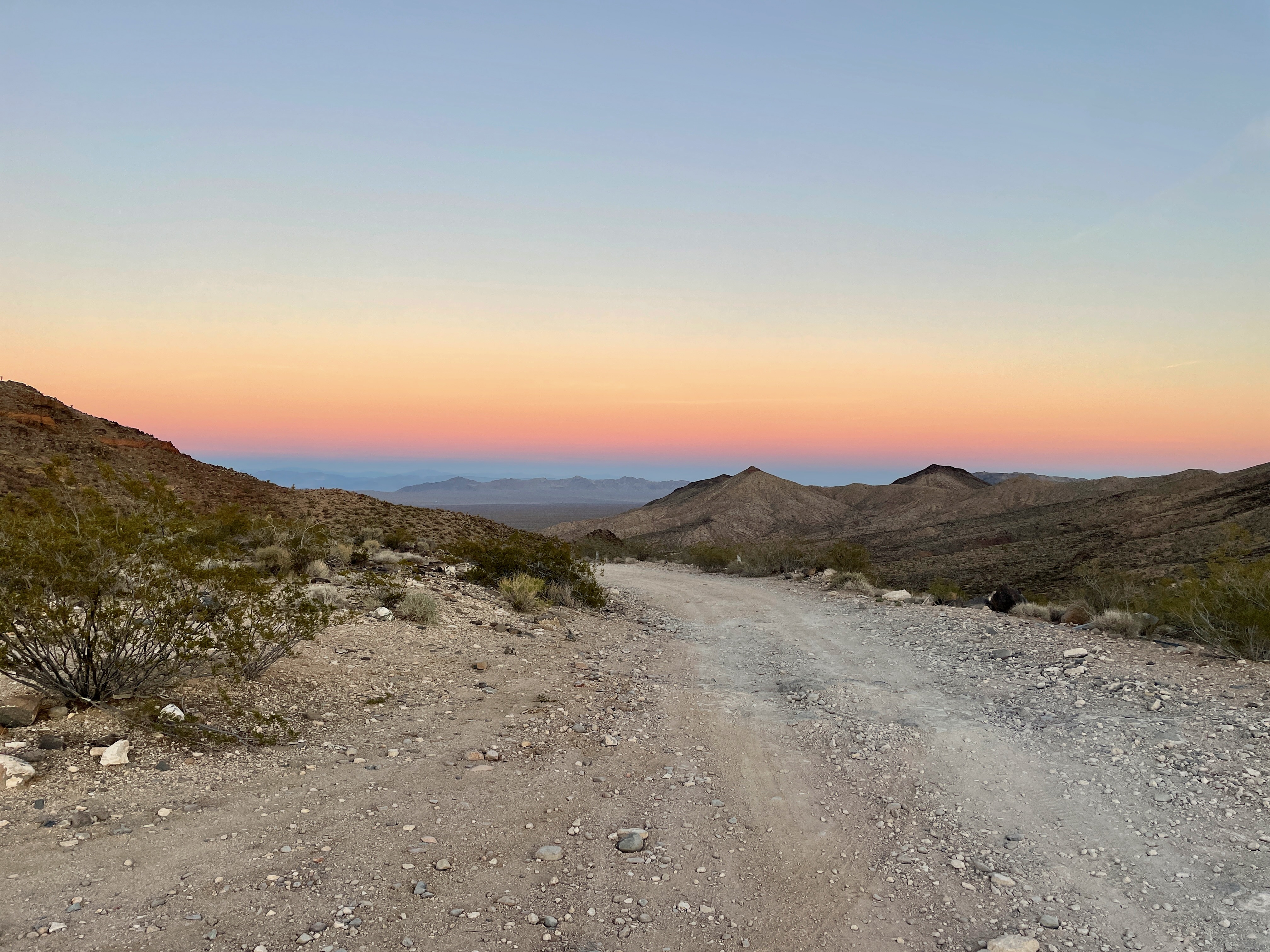
The trail rises gently through granite bedrock in a north west direction until after about 12 miles it crosses the California/Nevada boundary. Shortly after it crosses Highway 95 and continues west across the Piute Valley and Piute Creek. At around 23 miles the trail reaches Fort Piute. There are remains of the fort here along with signs of earlier inhabitants. The road for vehicles ends here and only a hiking trail continues on the path of the old Mohave Road. I had to double back and take a short bypass route around this obstruction to rejoin the true road further on.
 |
| Sunset in the Piute Range |
I stopped for the night at the head of the pass over the Piute Range of hills (around 3,500 ft elevation). It was a nice sunset and a beautiful remote location fro the night. Rather than pitch the tent I took the easy way out and slept in the back of the 4Runner.
 |
| The Piute Corral |
 |
| The Piute Corral |
In the morning after a short drive I again intersected the old Mojave Road again. Just north of the intersection was an old cattle corral, the Piute Corral. Still in fine shape after all these years.
 |
| Joshua Tree Country |
The road continues eastwards across the Lanfair Valley. I say road but it is not a paved road as such, it is all dirt, but apart from a few sections of roller coaster undulations a fairly good dirt road. It is Joshua Tree country here and there are some beautiful examples of these fine trees.
 |
| Leave a penny in the can |
Out to the south of the road there is a VORTAC beacon (an aircraft navigational aid) and shortly afterwards the road passes a tin can suspended from a Joshua Tree. It has become customary to deposit a penny or some other coin in this can as you pass by. I only had a quarter.
 |
| The Nevada Southern Railway Marker |
The road then crosses the Ivanpah/Lanfair Road and route of the old Nevada Southern Railway. The railway first built in the 1890's was long ago abandoned but there is a historical marker.
 |
| The drop to Watson Wash |
At around mile 49 the road drops steeply down into Watson Wash. This was perhaps the most challenging (i.e. fun) bit of the road, especially when soloing and you can't see over the hood of the car.
 |
| Rock Spring |
Shortly after the road reaches Rock Spring, another watering hole along the way. There are remnants of an Army Post there above the valley floor and higher up the slope there is an old stone house built in the 1930's that is still in good shape.
 |
| The Cabin at Rock Spring |
The road continues down Cedar Canyon (it's name becomes Cedar Canyon Road) and then crosses the Kelso-Cima Road as it crosses the Kelso Wash. The road in this section is relatively unremarkable as it crosses the wash to Marl Springs, another watering hole on the Mojave Road. There are occasional sand dunes along the way where the blowing sand has accumulated next to the low hills. The Kelso Dunes being a named example of these. Sometimes the road crosses these sand dunes but fortunately nothing to cause any problems with driving.
 |
| Kelso Wash and Sand Dunes |
The road then heads across a dry lake bed, Soda Lake. Thankfully there had been no rain in recent weeks so the surface was quite drivable. On the far side (the western side) of the lake is Soda Springs. Another spring where the Army established a post. There is a massive cairn of rocks there, known as the Travelers Monument that has presumably been created by rocks left by people passing that way.
 |
| The Travelers Monument |
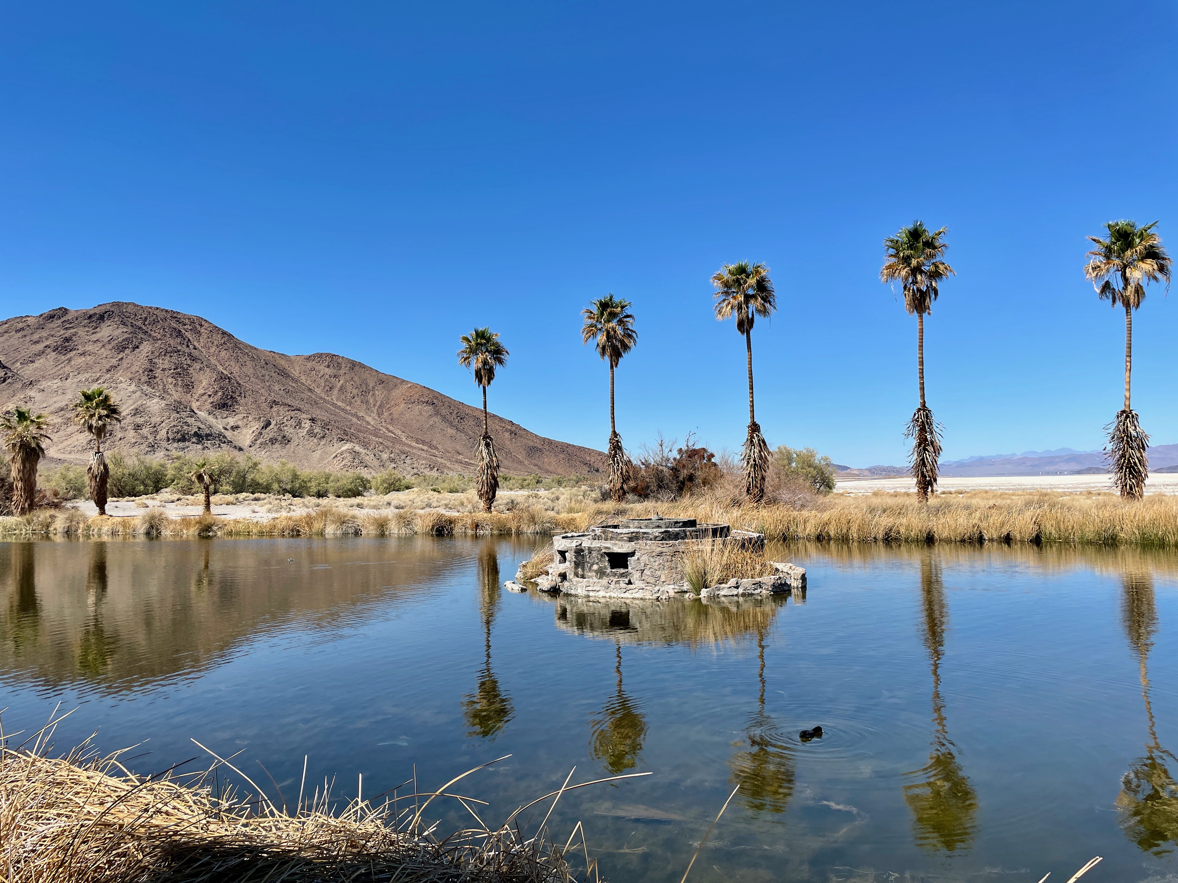
Just north of Soda Springs is the small settlement of Zzyzx. This was the Christian community created by Dr Curtis Springer in 1944 to provide help to the homeless and poor of the LA area. Zzyzx, named so that it would be the last word in the English Dictionary, grew from a tent camp to a more significant small town with buildings and a swimming pool and a lagoon. It gave many people a lift up in their livers but alas it all came to an end when in 1974 the BLM forced an eviction of Dr Springer and his entourage on rather dubious tax charges. It is now a University of California Desert Studies Center.
 |
| Zzyzx |
 |
| Zzyzx |
I took a look around Zzyzx and while there were a few cars there I found no sign of any people. It is one of those weird and wonderful places in the California Desert.
 |
Zzyzx
|
 |
| Someone had a dream in Zzyzx |
Leaving the Traveler's Monument the road crosses an area of sand that is a bit tricky to follow. The route is marked by cairns and poles but there are so many intersecting trails that it does get a little confusing. Still it was a fun drive at relatively high speed through the sand.
 |
| The Mojave River |
 |
| The Union Pacific crosses the Road |
After crossing the sand dunes the road intersects the Mojave River. At this time of year it is not much of a river but there is a trickle of water. I followed the bank of the river and then crossed over the river on to the other side. The road runs near the Union Pacific Railway here and I followed the river upstream and under the railway bridge. The road then enters Afton Canyon and for the next few miles I drove down the canyon on the sandy river bottom. I imagine in times of flood this is not passable but at this time it was a fun drive down the canyon.
 |
Afton Canyon
|
The canyon walls come together and the road gets closer to the railroad tracks. Finally there is a short section where the road follows quite close along the railway track bed. I don't think you would want to be there when a train is passing. At the end of this section, the railway crosses a bridge and the road drops down into a flooded section.
 |
| The Water Crossing |
I was a bit apprehensive about proceeding here. The water was wide and several hundred yards long and of unknown depth. I walked around the whole flooded section and probed and prodded at the water. It didn't seem too deep, and it appeared to have a firm sandy bottom. There were tracks of other vehicles that had obviously passed that way so I took a chance. It was fine. Not too deep and a firm footing. Shortly after the first water crossing there was another similar one. Again the going was good.
 |
Looking back towards Afton Canyon and the Campground
|
At this point there was a parking area and camping area, the Afton Canyon Campground. This was almost the end of the trail and I continued on down the Mojave River bed before finally turning up Manix Wash and joining the freeway (I-15). Rather than immediately get on the freeway I wanted to visit the final Army Camp on the road. I drove along a dirt road beneath a power line looking for Camp Cady. There was a marker near the location and it was supposed to be a short 3/4 mile walk to the ruins of the camp. I staggered around for a long time but I didn't find any sign of the camp so I finally gave up and headed back to the road.
 |
| End of the Road, Camp Cady |
I dined in nearby Barstow and stayed there overnight. The next day it was a long day's drive back to Sacramento with very fond memories of the Mojave Road.


No comments:
Post a Comment