At the end of August, I set off on what was going to be my longest every road trip. A drive across the country to Florida followed by a return to California. It seemed like a good idea several months ago when I decided to do it, but as it got closer I thought maybe it would be too much. I was going to pick up DIana in Florida and we would drive back together but it was going to be over 6,000 miles round trip.
Nevertheless, on a Friday morning after a doctor’s appointment and breakfast with the usual suspects, I set off from Sacramento. The plan was to take a direct route on the outward journey and then a more leisurely route on the way back. I drove down I-5 towards LA and then cut across to I-10 which would take me all the way across to Florida. Not much navigation required.
Somehow Google Maps had decided that there was a road closure on I-10 somewhere along its path and it always tried to route me away from that direction. The first mis-direction took me away from I-5 onto Hwy 99 and over the Tehachapis. I didn’t like that so I switched back to I-5 south of Bakersfield and ignored Google’s directions. For the rest of the trip it would periodically say that I-10 was closed and suggest another route, but other than a small diversion around a bridge in Arizona I didn’t see any closures on I-10.
Traveling south on 99 I passed signs of the construction effort on the high speed rail link being built from Southern California to the Bay Area. It looked impressive, but I wonder if it will ever get completed in my lifetime and what will the cost overruns be?
The Tejon pass is always impressive to drive. I just love the way it snakes up the hill from the flat lands of the San Joaquin Valley up to the top of the pass and then down into LA. I cut across on Highway 210, which cuts off the corner through Pasadena to join I-10 near San Bernardino. I stopped for dinner in San Bernardino and then drove on for a while more before stopping in Beaumont for the night.
 |
| Trump Supporters in Pasadena |
The next morning it was back on the road driving west. The same thing I would be doing for the next 5 or 6 days.
I traveled through the wind farm near Palm Springs and wondered as I have done many times before why some of the windmills are turning, while others are motionless. Is that deliberate? Are some windmills better lubricated than others?
It was then on through Indio, Coachella, to the border with Arizona at Blythe. The Colorado River is still a sizable river outside Blythe but I think most of its water is sucked out of it before it reaches the sea in Mexico.
 |
| Quartzite |
I stopped in Quartzite, the first town in Arizona. That is a quirky little place. There are many gas stations and fast food outlets but no reasonable coffee shops or diners. The rest of the economy there looks like it is derived from mineral and rock specimen shops and Native American tchotchkes.
 |
| Hi Jolly’s Grave in Quartzite |
They make a lot out of their association with camels in Quartzite. Back in the 1850’s before the railways were built in that area, the government decided that camels would be better than oxen or horses for transportation so they imported a hundred or so from Egypt and Turkey to form the US Camel Corp. That worked for a while until the Civil War diverted effort elsewhere. One of the US Camel Corps handlers, a Jordanian named Hadji Ali, or Hi Jolly as he was known, bought the remaining camels from the US Army and settled with them in Quartzite. His gravesite is in Quartzite and camels feature everywhere in town. Alas no camels exist there today.
 |
| Saguaro Cactus Quartzite |
I stopped to take a picture of a magnificent Saguaro cactus in the back of a tchotchke shop and the owner of the shop came out. I think he was wondering what was I doing on his property and I was realizing that he was wearing a pistol on his hip so I was on my best behavior. We had a nice chat and he showed me around the adjacent small garage that had a collection of well-restored old cars. We got on well, and despite the gun, I said I would stop by the next time I am in Quartzite.
 |
| Saguaro National Park, Arizona |
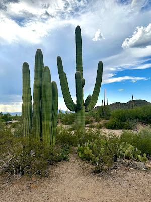
It was 110 degrees in Quartzite and that temperature was maintained as I drove across Arizona. I stopped for lunch on the outskirts of Phoenix and drove on towards Tucson. Before Tucson I turned off to the Saguaro National Park, some 20 or so miles south of I-10. The Saguaro cacti are quite magnificent and there were a lot of them. The Park Visitor Center was a wonderful building too but it was closed. I did a little hike around a trail at the Visitor Center and then continued on towards Tucson.
Thunder and lightning was rolling around the adjacent hills and as I drove towards Tucson it started to rain. I searched out a nice hotel and found one called the Lodge on the Desert that looked very nice and quite cheap. It was indeed a wonderful hotel, with a restaurant, a swimming pool, a hot tub and a beautiful room as well. I dined at the hotel where there was also a jazz band playing in the bar. Very nice.
 |
| St. Augustine’s Cathedral, Tucson |
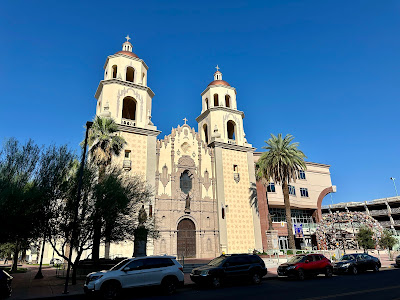
The next morning I set off to explore Tucson. The city has a nice feel to it. Large but not too large, very south-western with lots of cacti and adobe houses. I stopped by St Augustine’s Cathedral to have a quick look inside (there was a service going on, it was Sunday morning).
 |
| San Xavier Mission |
Then I searched out a mission that John G. had told me about. The mission San Xavier. This was some 20 miles south of Tucson out in the rural agricultural area. It was a beautiful mission, painted white with a terra cotta entry. In the parking lot in front of the church several stalls were being set up selling food and drinks.
 |
| San Xavier Mission Interior |
Inside the mission, it was even more beautiful. Wonderful carved and painted altars and chapels.
 |
| Benson, Arizona |
I moved on to the town of Benson, where I stopped for gas. There were some nice murals in the town depicting the towns western/cattle ranching/stage coach/railway heritage. While there a massive freight train came through town. I had been seeing these extremely long freight trains since I left San Bernardino. A lot of freight is being moved on these trains. They were quite frequent.
 |
| Tombstone Old West Fashion Show |
 |
| Tombstone Stage Coach |
I drove south to take a look at Tombstone. Tombstone of the “shootout at the OK corral” fame. I found it to be quite touristy and very cheesy. There was a western costume competition going on so there were a lot of people dressed in cowboy outfits and a lot of women dressed as ladies of the saloons.
 |
| Tombstone Courthouse |
I did tour the Tombstone Courthouse, which was run by the State of Arizona and so was not so touristy. They are very proud of their heritage and of Doc Holliday and what went on at the OK coral.
 |
| Butterfield Stage Motel, Deming |
I left Tombstone and headed back north to I-10 and continued my journey eastwards into New Mexico. I was searching for somewhere decent to eat but this area is a desert for eating places outside of McDonalds or Taco Bell. I stopped in Deming and drove through the town. There was nothing, save for a wonderful old motel sign for the Butterfield Stage Motel.
 |
| Typical House in Mesilla |
Outside of Las Cruces I turned off to the old town of Mesilla. This is an old historic town, once the capital of the confederate state of Arizona. It had a lot of fine adobe houses. It looked quite gentrified now.
Continuing over the border into El Paso, I decided to stay somewhere in the downtown area. I stayed in the wonderful old Plaza Hotel. This was on South El Paso Street that leads down to the Paso del Norte crossing into Mexico. I walked down to the border as the sun was setting.
 |
| The Rio Grande at El Paso |
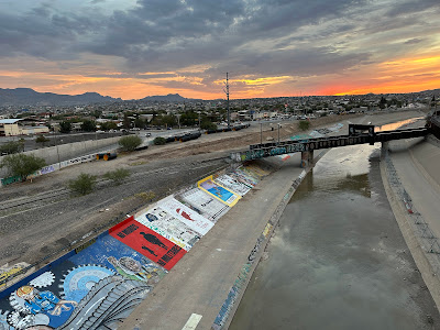
I inquired about crossing the border and they assured me that I could and that I could get back into the USA with my drivers license. I paid my 50c to get through the turnstile and I walked over the bridge over the Rio Grande and into Juarez, Mexico. On the way there was a lady having a struggle with her two bags so I offered to carry one for her. She was from Modesto and had just flown in. She was going over to Juarez, the town she was born in, to visit her mother who was in hospital. We had a nice chat as we walked across stopping from time to time to take pictures of the graffiti laden banks of the Rio Grande. Only graffitied on the Mexican side. The US side was bare concrete.
 |
| The Return to the USA, El Paso |
In Juarez I just walked across the road, through the long line of cars waiting to get over the bridge back to the US and paid another 50c to allow me to walk back to the USA. I thought of the film “No Country for Old Men” where the main character throws the bag of money into the bushes on the US side. Not possible now, likely never was. It is a concrete enclosed river with freeways running along both sides and railway as well as road bridge crossings.
I queued for about 20 minutes to get through customs on the US side and then walked back up the street to my hotel. A nice little adventure.
The next day I looked around for a decent breakfast place but didn’t find anything better than the Starbucks across from the hotel. So it was a latte for breakfast. I then set off to see a few sites in El Paso.
 |
| Bhutanese Temple, UT El Paso |
First was the Bhutanese Temple on the grounds of the University of Texas. The campus was deserted (it was Labor Day). The temple was quite beautiful sitting there in the middle of all the university buildings. A gift from the King of Bhutan to the University of Texas.
 |
| Casa de Azucar |
Next stop was the Casa de Azucar. A suburban house decorated with carved concrete objects - flowers, religious symbols, altars. Apparently the owner spent 25 years chiseling and then painting these decorations. Just a simple house on a simple street in El Paso.
 |
| Chicano Park, El Paso |
The next stop was Lincoln Park or Chicano Park, an area under a sprawling freeway intersection that has been decorated with impressive Chicano murals. A bunch of guys were playing handball in a court area beneath the freeway. A nice protected court as it was pouring down with rain.
 |
| John Wesley Hardin Gravesite |
Finally I went to look at John Wesley Hardin’s grave. He was an outlaw who apparently claimed to have killed 42 men. Somehow he managed to convince the law that most were in self defense and so only got a 25 year sentence. He studied law in prison, was pardoned and set up a law office in El Paso. He was shot and killed shortly after his release and was buried right there in El Paso.
 |
| Border Control I-10 outside El Paso |
The rain was now pretty continuous and I set out to travel through West Texas. A long and tedious part of the journey. Just outside of El Paso there was a border control point and all cars and trucks were stopped and inspected for illegal immigrants. I was let through.
 |
| Van Horn’s homage to Jeff Bezos |
Like the previous day it was a fairly boring drive and I was again looking for a decent place to eat. Sadly nothing was to be found. In Van Horn there was a small Blue Horizon mural with a smiling Jeff Bezos on it. The launch site for Blue Horizon’s rockets is 30 miles north of Van Horn. Van Horn didn’t seem to be prospering from its proximity to the launch site.
 |
| Fort Stockton’s Roadrunner |
In Fort Stockton I again stopped trying to find a coffee shop. Nothing interesting was to be found so I ended up in a Dennys. Fort Stockton is miles from anywhere and is quite desolate. The ruins of an old fort, a metal roadrunner statue by the welcome sign, but little else.
I drove on through the sometimes torrential rain with streams running down the side of the road until I reached Junction where I stayed for the night. The only non-fast food place was a barbecue restaurant. It looked promising, though not my first choice of food, but it was sold out of all meat except brisket. A bad food day and it was still raining.
 |
| The Alamo, San Antonio |
The next morning I pushed on from the damp and desolate Junction towards San Antonio. Even though it was raining I decided to stop in San Antonio and take another look at The Alamo. It is not the most memorable of buildings - rather small really but I suppose it has some historical importance.
On to Houston where I visited friends and stayed for the night. Finally a chance for some really nice food.
The next day, Wednesday, I pushed on towards Louisiana, through the refineries of East Texas. Again it was pouring down with rain, sometimes bad enough to make driving on the freeway a little scary. I stopped for gas in Vidor near the Louisiana border. Not a very remarkable town.
 |
| Somewhere in Louisiana |
In Louisiana, the road continued through Lake Charles, Lafayette and over the Mississippi at Baton Rouge before arriving in New Orleans. I was going to stay there but it was raining so hard I thought I would be better just driving on so I did. It was another good food desert. I had been seeing signs for Cracker Barrel restaurants that looked interesting so I stopped to try one. A big mistake. Lots of heavy fried food served to overweight clientele by overweight waiters. I regretted it.
I continued driving into Mississippi - Biloxi and Pascagoula - and then out into Alabama - Mobile - and further into Florida. I stopped for the night in Pensacola.
I now had the bit between my teeth and was smelling the barn so I pushed on the next morning without any sightseeing along the way. East to Tallahassee and then turning off I-10 the road I had been on since LA, and heading south to St Petersburg. Arriving there around 6:00 in the evening. A total of 3,086 in 7 days. I was ready for a well earned rest.
No comments:
Post a Comment